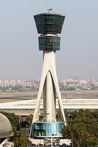
Air traffic control (ATC) is a service provided by ground-based air traffic controllers who direct aircraft on the ground and through a given section of controlled airspace, and can provide advisory services to aircraft in non-controlled airspace. The primary purpose of ATC is to prevent collisions, organize and expedite the flow of traffic in the air, and provide information and other support for pilots.
Orokolo is a Trans–New Guinea language of the Eleman branch spoken in Ihu Rural LLG, Gulf Province, Papua New Guinea by about 50,000 people (2010). Alternate names are Bailala, Haira, Kaipi, Kairu-Kaura, Muro, Muru, Vailala, and West Elema. It is spoken in various villages, including Vailala. It is notable for having a very small consonant inventory.

The nose flute is a musical instrument often played in Polynesia and the Pacific Rim countries. Other versions are found in Africa.

The Canada Flight Supplement (CFS) is a joint civil/military publication and is a supplement of the Aeronautical Information Publication. It is the nation's official airport directory. It contains information on all registered Canadian and certain Atlantic aerodromes and certified airports.

The Digital Aeronautical Flight Information File or DAFIF is a comprehensive database of up-to-date aeronautical data, including information on airports, airways, airspaces, navigation data, and other facts relevant to flying in the entire world, managed by the National Geospatial-Intelligence Agency (NGA) of the United States.

Severo-Evensk Airport is an airport serving and located 1 kilometre (0.62 mi) northwest of Evensk in Severo-Evensky District, Magadan Oblast, Russia. It is a small engineered airfield with concrete parking area. It handles small transport aircraft.
Uray Airport is an airport in Khanty-Mansi Autonomous Okrug, Russia located 4 km southeast of Uray. It services up to medium-sized airliners.

Ulyanovsk Vostochny Airport is an airport in Russia located 28 kilometres (17 mi) northeast of Ulyanovsk in Russia. Its runway is tied with Shigatse Peace Airport in China as the longest public use runway in the world with a length of 5,000 metres (16,000 ft). The runway is also the widest, with a total width of about 105 metres (344 ft). The airport also features a very long taxiway that connects to the local Aviastar plant. This airport is mainly a cargo airport. It was founded in 1983 as a test site for the neighbouring Aviastar plant. It is a base for Volga-Dnepr Airlines. Also located here is Aviastar-SP, the manufacturer of the Antonov An-124 and Tupolev Tu-204.

Pichoy Airport is an airport 32 kilometres (20 mi) northeast of Valdivia, a city in the Los Ríos Region of Chile. The airport lies next to Pichoy River.

Diego Aracena International Airport is an airport serving Iquique, capital of the Tarapacá Region in Chile. The airport is on the Pacific coast 48 kilometres (30 mi) south of the city. It shares a runway with Los Cóndores Air Base, home to the First Air Brigade of the Chilean Air Force.

The Imam Hossein Comprehensive University is a public university located in Tehran, Iran.
Lake Gregory – Mulan Airport is an airport located in Mulan, serving Lake Gregory region, Western Australia.
Victoria Airport is an airport serving Victoria, a town in the Araucanía Region of Chile. The airport is on the southwest side of the town.

Te Tau Ihu Māori are a group of Māori iwi in the upper South Island of New Zealand. It includes Ngāti Kuia, Rangitāne, Ngāti Tūmatakōkiri and Ngāti Apa ki te Rā Tō, Ngāti Koata, Ngāti Rārua and Ngāti Toa, and Ngāti Tama and Te Atiawa o Te Waka-a-Māui.
Ihu Rural LLG is a local-level government (LLG) of Gulf Province, Papua New Guinea.

Marlui Miranda is a Brazilian singer, musician, and researcher known for her performances of indigenous music from the Amazon. She has collaborated with Brazilian musicians Gilberto Gil, Egberto Gismonti, Milton Nascimento, and Nana Vasconcelos.
The Instituts hospitalo-universitaires (IHU) are medical training and research centers. They have been created by former French President Nicolas Sarkozy in 2009. The instituts hospitalo-universitaires are in partnership with universities, hospitals as well as research laboratories both private and public.


