
The North Eastern Province is one of the former provinces in Kenya. It has a land area of 127,358.5 km2, with its capital at Garissa. Previously known as the Northern Frontier District (NFD), Now The North Eastern Province territory was carved out of the present-day southern Somalia during the colonial period. It is and has historically been exclusively inhabited by ethnic Somalis.

Lamu County is located in the Northern Coast of Kenya and is one of the Six Coastal Counties in Kenya. It borders Tana River County in the southwest, Garissa County to the north, Republic of Somalia to the northeast and the Indian Ocean to the South. It lies 1° 40’ and 2° 30’south and longitude 40° 15’ and 40° 38’south. The County has a land surface of 6,273.1 km that include the mainland and over 65 islands that form the Lamu Archipelago. The total length of the coastline is 130 km while land water mass area stands at 308 km.

Garissa is the capital of Garissa County, Kenya. It is situated in the former North Eastern Province. Residential areas in Garissa are called bulas. The main bulas are Bula Taqwa, Mzuri, Garissa yarey, Bula punda, Bula sheikh, Bula cadan, and Bula rig.
Isiolo County is a county in the former Eastern Province of Kenya. Its population is 268,002 and its capital is Isiolo. Isiolo County is to be the first county to be developed as part of the Kenya Vision 2030 program. Its capital and largest town is Isiolo. Other upcoming urban centres are: Garbatulla, Modogashe, Kinna, Merti and Oldonyiro.

Local authorities in Kenya are the bodies controlling local governance in urban areas in Kenya.
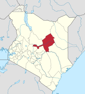
Garissa County is an administrative County in the former North Eastern Province of Kenya. Its capital and largest urban area is Garissa. As of August 31, 2016, Garissa county had more than 260,000 Somali refugees in refugee camps at Dadaab, which is located in Garissa County. The county has a population of 400,060, and a land area of about 45,720.2 km2 (17,652.7 sq mi).

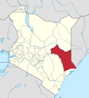
Wajir County is a county in the former North Eastern Province of Kenya. Its capital and largest town is Wajir. The county has a population of 781,263 and an area of 55,840.6 km². The county is bordered to the north by Ethiopia, to the northeast by Mandera County, to the east by Somalia, to the south by Garissa County, to the west by Isiolo County and to the northwest by Marsabit County. The county has six constituencies: Eldas, Tarbaj, Wajir North, Wajir West, Wajir East, and Wajir South.
Ijara was a former administrative district in the North Eastern Province of Kenya. On May 20, 2000, it was carved out from the larger Garissa District. It covered an area of 11,332 km2 and, according to the population census of 1999, had a population of 62,571. It bordered Garissa District to the north, Lamu District to the south, Tana River District to the west, and Somalia to the northeast. The district had one local authority, Ijara county council, and one constituency, Ijara Constituency. In 2010, it was amalgamated with Garissa County.
Liboi is a town in Garissa County, Kenya, at the border with Somalia.
The districts of Kenya are divided into 262 divisions (matarafa). Divisions of Kenya are further subdivided into locations. The counties of Kenya are based on the merging of some of the districts on this list and since the divisions are one level under the districts they are the sub-counties. This is because Kenya recently changed its constitution and 47 Counties emerged. Here are the divisions listed below, by district :

The Arawale National Reserve is a designated conservation area managed by the Garissa County in assistance with the Kenya Wildlife Service. It lies in North Eastern Province of Kenya, 77 km south of the town of Garissa. The reserve covers an area of 53,324 hectares. To the west, it is bordered by the Tana River and, to the east, by the Garissa-Lamu road. In 1974, the reserve was gazetted as the only in-situ conservation site for the critically endangered Hirola population endemic to north-eastern Kenya and south-west Somalia.
The Boni National Reserve is a national reserve for conservation and lies in the Garissa County, Kenya. The reserve covers an area of 1,339 km2 (517 sq mi) and is managed by Kenya Wildlife Service. It was gazetted in 1976 as a dry season sanctuary for elephants in the former Kenyan Ijara, and Lamu districts and Somalia. Unfortunately, elephant population has been greatly reduced by poaching.
The Ishaqbini Hirola Conservancy is a community-based conservation area located in Garissa County, Kenya. The conservancy covers approximately 72 km2. It is located along the eastern bank of the Tana River, and borders the former Tana River Primate Reserve (1976−2007).
The Bour-Algi Giraffe Sanctuary is a community-based conservation and natural resource management initiative. The sanctuary is located in Garissa County, Kenya, in the area surrounding the village of Bour-Algi, 5 km south of Garissa town. The sanctuary covers an area of around 125 km² and borders the Tana River to the south-west. Its name stems from the large presence of giraffes attracted by the abundant acacia trees. Estimates state almost 1000 giraffes living in the outskirts of the Bour-Algi village.
Tropical diseases, especially malaria and tuberculosis, have long been a public health problem in Kenya. In recent years, infection with the human immunodeficiency virus (HIV), which causes acquired immune deficiency syndrome (AIDS), also has become a severe problem. Estimates of the incidence of infection differ widely.
Farah Maalim Mohamed is a Kenyan politician. He is the former Deputy Speaker of the National Assembly of Kenya, and has almost twenty-five years of experience on the Kenyan political scene. He is of Somali ethnicity.
Ijara Constituency is an electoral constituency in Kenya. It is one of six constituencies in Garissa County. It was the sole constituency in the former Ijara District. The constituency was established for the 1988 elections. The constituency has seven wards, all electing councillors for the Ijara County Council.
Masalani is a town in Garissa County, Kenya. It was previously the headquarters of the former Ijara District. It is located on the Eastern shores of Tana River, 30 kilometres south of Hola and 60 kilometres north of Garsen
Sub-counties are the decentralised units through which county governments of Kenya will provide functions and services. Except for the parts which fall under urban areas, sub-counties will coincide with the constituencies created under article 89 of the Constitution of Kenya. Sub-counties will be headed by a sub-county administrator, appointed by a County Public Service Board.
On 2 April 2015, gunmen stormed the Garissa University College in Garissa, Kenya, killing 148 people, and injuring 79 or more. The militant group and Al-Qaeda offshoot, Al-Shabaab, which the gunmen claimed to be from, took responsibility for the attack. The gunmen took over 700 students hostage, freeing Muslims and killing those who identified as Christians. The siege ended the same day, when all four of the attackers were killed. Five men were later arrested in connection with the attack, and a bounty was placed for the arrest of a suspected organizer.


