Vanylven is a municipality in Møre og Romsdal county, Norway. It is part of the Sunnmøre region. The administrative centre is the village of Fiskåbygd. Other villages in the municipality include Sandnes, Åheim, Åram, Rovdane, Eidså, Slagnes, and Myklebost.

Ørsta (help·info) is a municipality in Møre og Romsdal county, Norway. It is part of the Sunnmøre region of Western Norway. The administrative centre of the municipality is the village of Ørsta. Other villages in the municipality include Hovdebygda, Flåskjer, Leira, Liadal, Urke, Bjørke, Barstadvik, Åmdalen, Follestaddalen, Nordre Vartdal, Vartdal, Sæbø, Sætre, Store-Standal, and Ytre Standal.

Sykkylven is a municipality in Møre og Romsdal county, Norway. It is part of the Sunnmøre region. The administrative centre is the village of Aure. Other villages in the municipality include Ikornnes, Straumgjerde, and Tusvik.

Tusvik or Tusvika is a small village in Sykkylven Municipality in Møre og Romsdal county, Norway. It is located along the Storfjorden about 4 kilometres (2.5 mi) west of the village of Ikornnes and 8 kilometres (5.0 mi) west of the municipal center, Aure.
The Sykkylven Bridge is a concrete bridge that crosses the Sykkylvsfjorden in Sykkylven Municipality in Møre og Romsdal county, Norway. It connects the municipal center of Aure with the village of Ikornnes on the other side of the fjord.

Norheimsund is the administrative centre of the municipality of Kvam in Hordaland county, Norway. The village is located on the northern side of the Hardangerfjord, about 80 kilometres (50 mi) from the city of Bergen. The village of Øystese lies about 4 kilometres (2.5 mi) to the northeast and the village of Vikøy lies about 3 kilometres (1.9 mi) southeast of Norheimsund. The village of Steine is a suburb, immediately to the west of Norheimsund. The 2.5-square-kilometre (620-acre) village has a population (2012) of 2,224; giving the village a population density of 890 inhabitants per square kilometre (2,300/sq mi), the largest settlement in the whole municipality.
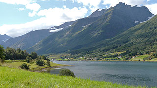
Straumgjerde is a village in Sykkylven Municipality in Møre og Romsdal county, Norway. The village is located where the lake Fitjavatnet empties into the Sykkylvsfjorden. It is about 6 kilometres (3.7 mi) south of the municipal center of Aure and about 11 kilometres (6.8 mi) south of Ikornnes. The mountain Råna lies 6 kilometres (3.7 mi) south of the village.
Valle is a village in Skodje Municipality in Møre og Romsdal county, Norway. The village is located on the eastern end of the island of Oksenøya, along the northern shore of the Storfjorden. Valle sits along the European route E39/European route E136 highway, about 5 kilometres (3.1 mi) south of the municipal center of Skodje, 28 kilometres (17 mi) east of the city of Ålesund, and 11 kilometres (6.8 mi) west of Sjøholt in Ørskog Municipality.
Myklebost or Myklebust is a village in Ålesund Municipality in Møre og Romsdal county, Norway. It is located on the south side of the island of Ellingsøya, about 4 kilometres (2.5 mi) west of the village of Årset and about 5 kilometres (3.1 mi) east of the village of Hoffland. Myklebost is about 10 kilometres (6.2 mi) northeast of the city center of Ålesund.

Eidsvåg is a village in Nesset Municipality in Møre og Romsdal county, Norway. It is the administrative centre of the municipality. Eidsvåg is located at the end of the Langfjorden on the isthmus connecting the Romsdal peninsula to the Norwegian mainland. It is located about 8.5 kilometres (5.3 mi) southwest of the village of Raudsand, about 20 kilometres (12 mi) north of the village of Eresfjord, and 9 kilometres (5.6 mi) north of the village of Boggestranda. Nesset Church is located in this village.

Sogndalsfjøra is the administrative center of the municipality of Sogndal in Sogn og Fjordane county, Norway. It is located where the river Sogndalselvi runs out in the Sogndalsfjorden, a branch of the large Sognefjorden. The village is located about 3.5 kilometres (2.2 mi) northwest of the village of Kjørnes, about 10 kilometres (6.2 mi) northwest of the village of Kaupanger, and about 31 kilometres (19 mi) southeast of the village of Fjærland.

Sande is the administrative centre of the municipality of Gaular in Sogn og Fjordane county, Norway. The village is located along the Gaula River, about 10 kilometres (6.2 mi) from where the river meets the Dalsfjorden. The 0.59-square-kilometre (150-acre) village has a population (2013) of 745, giving the village a population density of 1,263 inhabitants per square kilometre (3,270/sq mi). Sande Church is located in this village, serving the people of the central part of the municipality.

Dale or Dale i Sunnfjord is the administrative centre of the municipality of Fjaler in Sogn og Fjordane county, Norway. The village is located at the mouth of the river Vassdalselva on the southern shore of the Dalsfjorden in the northern part of Fjaler, about 6.5 kilometres (4.0 mi) northeast of the village of Flekke and about 20 kilometres (12 mi) west of the village of Bygstad.

Bru or Ploganes is a village in the municipality of Kvam in Hordaland county, Norway. It's located in the Strandebarm area, on the northern shore of the Hardangerfjorden. It is located about 6 kilometres (3.7 mi) north of the village of Omastranda and about 10 kilometres (6.2 mi) northwest from the village of Kysnesstranda in Jondal Municipality.

Råna is a mountain in Møre og Romsdal county, Norway. The mountain sits on the municipal border between Ørsta Municipality and Sykkylven Municipality. It is part of Hjelledalstindane mountains in the Sunnmørsalpene range. The 1,586-metre (5,203 ft) tall mountain is located about 8 kilometres (5.0 mi) east of the village of Store Standal in Ørsta Municipality and about 7 kilometres (4.3 mi) south of the village of Straumgjerde in Sykkylven Municipality.

Spillum is a village in the municipality of Namsos in Trøndelag county, Norway. The village is located along the south side of the Namsen river about 5 kilometres (3.1 mi) directly south of the centre of the town of Namsos and about 4 kilometres (2.5 mi) north of the village of Klinga. The Norwegian Sawmill Museum is located in the village of Spillum.
Aure is the administrative center of Sykkylven Municipality in Møre og Romsdal county, Norway. The village is located along the eastern shore of the Sykkylvsfjorden. It is about 7 kilometres (4.3 mi) north of Straumgjerde and 3 kilometres (1.9 mi) east of Ikornnes.
Årset is a village in Ålesund Municipality in Møre og Romsdal county, Norway. The village is located along the Ellingsøyfjorden on the southern shore of the island of Ellingsøya, about 4 kilometres (2.5 mi) east of the village of Myklebost and about 12 kilometres (7.5 mi) west of the village of Tennfjord in Haram Municipality.