Sykkylven is a municipality in Møre og Romsdal county, Norway. It is part of the Sunnmøre region. The administrative centre is the village of Aure. Other villages in the municipality include Ikornnes, Straumgjerde, and Tusvik.

Norheimsund is the administrative centre of the municipality of Kvam in Hordaland county, Norway. The village is located on the northern side of the Hardangerfjord, about 80 kilometres (50 mi) from the city of Bergen. The village of Øystese lies about 4 kilometres (2.5 mi) to the northeast and the village of Vikøy lies about 3 kilometres (1.9 mi) southeast of Norheimsund. The village of Steine is a suburb, immediately to the west of Norheimsund. The 2.5-square-kilometre (620-acre) village has a population (2012) of 2,224; giving the village a population density of 890 inhabitants per square kilometre (2,300/sq mi), the largest settlement in the whole municipality.

Steinshamn is the administrative centre of Sandøy Municipality in Møre og Romsdal county, Norway. The village is located at the northern end of the island of Harøya. There is a causeway that connects Steinshamn to the neighboring island of Finnøya to the northeast.

Sandane is the administrative centre of the municipality of Gloppen in Sogn og Fjordane county, Norway. It is located at the end of the Gloppefjorden, along the European route E39 highway. Sandane is 20 kilometres (12 mi) south of the village of Nordfjordeid and about 16 kilometres (9.9 mi) west of the village of Byrkjelo. Sandane Airport, Anda is located 10 kilometres (6.2 mi) northwest of Sandane along highway E39. Sandane has several suburban areas that surround the nearby fjord such as Sørstranda to the west and Vereide to the northwest.
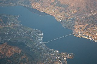
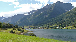
Ikornnes is a village in Sykkylven Municipality in Møre og Romsdal county, Norway. It is located along the Sykkylvsfjorden, about 4 kilometres (2.5 mi) east of Tusvik, 7 kilometres (4.3 mi) north of Straumgjerde, and about 3 kilometres (1.9 mi) west of the municipal center of Aure via the Sykkylven Bridge.
Valle is a village in Skodje Municipality in Møre og Romsdal county, Norway. The village is located on the eastern end of the island of Oksenøya, along the northern shore of the Storfjorden. Valle sits along the European route E39/European route E136 highway, about 5 kilometres (3.1 mi) south of the municipal center of Skodje, 28 kilometres (17 mi) east of the city of Ålesund, and 11 kilometres (6.8 mi) west of Sjøholt in Ørskog Municipality.
Myklebost or Myklebust is a village in Ålesund Municipality in Møre og Romsdal county, Norway. It is located on the south side of the island of Ellingsøya, about 4 kilometres (2.5 mi) west of the village of Årset and about 5 kilometres (3.1 mi) east of the village of Hoffland. Myklebost is about 10 kilometres (6.2 mi) northeast of the city center of Ålesund.

Eidsvåg is a village in Nesset Municipality in Møre og Romsdal county, Norway. It is the administrative centre of the municipality. Eidsvåg is located at the end of the Langfjorden on the isthmus connecting the Romsdal peninsula to the Norwegian mainland. It is located about 8.5 kilometres (5.3 mi) southwest of the village of Raudsand, about 20 kilometres (12 mi) north of the village of Eresfjord, and 9 kilometres (5.6 mi) north of the village of Boggestranda. Nesset Church is located in this village.
Eivindvik is the administrative centre of the municipality of Gulen in Sogn og Fjordane county, Norway. The village is located on the mainland, along the north shore of the Gulafjorden. It is also located about 5 kilometres (3.1 mi) south of the village of Dingja, about 6 kilometres (3.7 mi) northwest of the village of Dalsøyra, and about 15 kilometres (9.3 mi) northeast of the village of Byrknes.

Sogndalsfjøra is the administrative center of the municipality of Sogndal in Sogn og Fjordane county, Norway. It is located where the river Sogndalselvi runs out in the Sogndalsfjorden, a branch of the large Sognefjorden. The village is located about 3.5 kilometres (2.2 mi) northwest of the village of Kjørnes, about 10 kilometres (6.2 mi) northwest of the village of Kaupanger, and about 31 kilometres (19 mi) southeast of the village of Fjærland.

Sande is the administrative centre of the municipality of Gaular in Sogn og Fjordane county, Norway. The village is located along the Gaula River, about 10 kilometres (6.2 mi) from where the river meets the Dalsfjorden. The 0.59-square-kilometre (150-acre) village has a population (2013) of 745, giving the village a population density of 1,263 inhabitants per square kilometre (3,270/sq mi). Sande Church is located in this village, serving the people of the central part of the municipality.
Sandeid is a village in Vindafjord municipality in Rogaland county, Norway. The village is located at the head of the Sandeidfjorden, about 7 kilometres (4.3 mi) northwest of the village of Vikedal and about 11 kilometres (6.8 mi) south of the village of Ølensjøen. The 0.61-square-kilometre (150-acre) village has a population (2013) of 622, giving the village a population density of 1,020 inhabitants per square kilometre (2,600/sq mi).

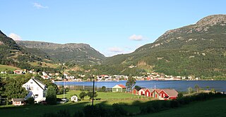
Vikedal or Vikadal is a village in Vindafjord municipality in Rogaland county, Norway. The village is located along the krosfjorden, about 7 kilometres (4.3 mi) south of the village of Sandeid and about 8 kilometres (5.0 mi) northwest of the village of Imslandsjøen. Vikedal Church is located in this village.

Raudeberg is a village in Vågsøy Municipality in Sogn og Fjordane county, Norway. It is located on the east side of the island of Vågsøy. The villages of Refvika, Vedvika, and Langeneset are located a few kilometers to the north, and the town of Måløy is about 6 kilometres (3.7 mi) to the south. The island of Silda is located about 2 kilometres (1.2 mi) northeast of the village of Raudeberg. Nord-Vågsøy Church is located on the eastern edge of the village, right along the coast.

Bru or Ploganes is a village in the municipality of Kvam in Hordaland county, Norway. It's located in the Strandebarm area, on the northern shore of the Hardangerfjorden. It is located about 6 kilometres (3.7 mi) north of the village of Omastranda and about 10 kilometres (6.2 mi) northwest from the village of Kysnesstranda in Jondal Municipality.
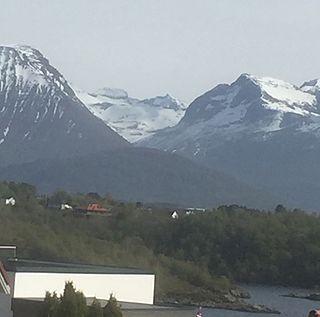
Råna is a mountain in Møre og Romsdal county, Norway. The mountain sits on the municipal border between Ørsta Municipality and Sykkylven Municipality. It is part of Hjelledalstindane mountains in the Sunnmørsalpene range. The 1,586-metre (5,203 ft) tall mountain is located about 8 kilometres (5.0 mi) east of the village of Store Standal in Ørsta Municipality and about 7 kilometres (4.3 mi) south of the village of Straumgjerde in Sykkylven Municipality.
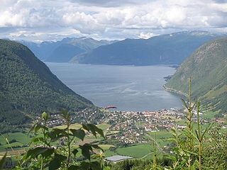
Vikøyri is the administrative center of the municipality of Vik in Sogn og Fjordane county, Norway. The village is located at the mouth of the Vikja river on the south shore of the Sognefjorden, roughly near the midpoint of Norway's longest fjord. The village lies along Norwegian National Road 13 which leads north to the ferry to Balestrand and south to the village of Vossevangen. The 1.26 square kilometres village of Vikøyri has a population (2013) of 1,195; giving the village a population density of 948 inhabitants per square kilometre (2,460/sq mi).
Søfteland or Syfteland is a village in Os municipality in Hordaland county, Norway. It lies on the Bergen Peninsula, along the European route E39 highway, about 6 kilometres (3.7 mi) north of the municipal centre of Osøyro and about 20 kilometres (12 mi) south of the city of Bergen. The mountain Møsnuken lies about 3.5 kilometres (2.2 mi) east of the village and the mountain Lyshornet lies about 2.3 kilometres (1.4 mi) west of the village. The 0.94-square-kilometre (230-acre) village has a population (2013) of 1425, giving the village a population density of 1,516 inhabitants per square kilometre (3,930/sq mi).
Aure is the administrative center of Sykkylven Municipality in Møre og Romsdal county, Norway. The village is located along the eastern shore of the Sykkylvsfjorden. It is about 7 kilometres (4.3 mi) north of Straumgjerde and 3 kilometres (1.9 mi) east of Ikornnes.

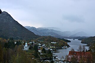
Jondal is the administrative centre of Jondal municipality in Hordaland county, Norway. The village is located on the southern shore of the Hardangerfjorden, about 55 kilometres (34 mi) southeast of the city of Bergen. It is located on the Folgefonna peninsula, about 12 kilometres (7.5 mi) northwest of the Folgefonna glacier in Folgefonna National Park. The village of Kysnesstranda lies about 15 kilometres (9.3 mi) to the south. The 0.59-square-kilometre (150-acre) village has a population (2013) of 379, giving the village a population density of 642 inhabitants per square kilometre (1,660/sq mi).