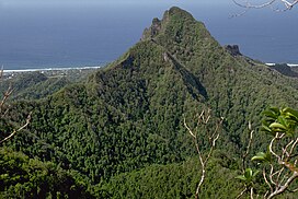
The Cook Islands is an island country in Polynesia, part of Oceania in the South Pacific Ocean. It consists of 15 islands whose total land area is approximately 236.7 square kilometres (91 sq mi). The Cook Islands' Exclusive Economic Zone (EEZ) covers 1,960,027 square kilometres (756,771 sq mi) of ocean. Avarua is its capital.

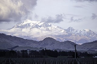
Aoraki / Mount Cook is the highest mountain in New Zealand. Its height, as of 2014, is listed as 3,724 metres. It sits in the Southern Alps, the mountain range that runs the length of the South Island. A popular tourist destination, it is also a favourite challenge for mountain climbers. Aoraki / Mount Cook consists of three summits: from south to north, the Low Peak, the Middle Peak and the High Peak. The summits lie slightly south and east of the main divide of the Southern Alps, with the Tasman Glacier to the east and the Hooker Glacier to the southwest. Mount Cook is ranked 10th in the world by topographic isolation.

The South Island, also named Te Waipounamu in Māori, is the larger of the two major islands of New Zealand in surface area, the other being the smaller but more populous North Island. It is bordered to the north by Cook Strait, to the west by the Tasman Sea, and to the south and east by the Pacific Ocean. The South Island covers 150,437 square kilometres (58,084 sq mi), making it the world's 12th-largest island, constituting 56% of New Zealand's land area. At low altitudes, it has an oceanic climate.

Sir Edmund Percival Hillary was a New Zealand mountaineer, explorer, and philanthropist. On 29 May 1953, Hillary and Sherpa mountaineer Tenzing Norgay became the first climbers confirmed to have reached the summit of Mount Everest. They were part of the ninth British expedition to Everest, led by John Hunt. From 1985 to 1988 he served as New Zealand's High Commissioner to India and Bangladesh and concurrently as Ambassador to Nepal.

Banks Peninsula is a peninsula of volcanic origin on the east coast of the South Island of New Zealand. It has an area of approximately 1,150 square kilometres (440 sq mi) and encompasses two large harbours and many smaller bays and coves. The South Island's largest city, Christchurch, is immediately north of the peninsula.

Aoraki / Mount Cook National Park is a national park located in the central-west of the South Island of New Zealand. It was established in October 1953 and takes its name from the highest mountain in New Zealand, Aoraki / Mount Cook. The area of the park is 707 km2 (273 sq mi), and it shares a border with Westland Tai Poutini National Park along the Main Divide of the Southern Alps. The national park consists of reserves that were established as early as 1885 to protect the area's significant landscape and vegetation. Glaciers cover 40% of the park, including the county's largest glacier, Haupapa / Tasman Glacier. In 1990, the park was included in the area designated as the Te Wāhipounamu World Heritage Site. The park is managed by the Department of Conservation (DOC) alongside Ngāi Tahu, the iwi who are mana whenua in the region.

Mount Taranaki is a dormant stratovolcano in the Taranaki region on the west coast of New Zealand's North Island. At 2,518 metres (8,261 ft), it is the second highest mountain in the North Island, after Mount Ruapehu. It has a secondary cone, Fanthams Peak, 1,966 metres (6,450 ft), on its south side.

Mount Hutt rises to the west of the Canterbury Plains in the South Island of New Zealand, above the braided upper reaches of the Rakaia River, and 80 kilometres west of Christchurch. Its summit is 2190 metres above sea level.

Mount Aspiring / Tititea is New Zealand's 23rd-highest mountain. The peak's altitude of 3,033 metres (9,951 ft) makes it the country's highest outside the Aoraki / Mount Cook region.

Mount Tasman is New Zealand's second-highest mountain, rising to a height of 3,497 metres (11,473 ft). It is located in the Southern Alps of the South Island, four kilometres to the north of its larger neighbour, Aoraki / Mount Cook. Unlike Aoraki / Mount Cook, Mount Tasman sits on the South Island's Main Divide, on the border between Aoraki / Mount Cook National Park and Westland Tai Poutini National Park. It is the highest point in Westland District.
Tapuae-o-Uenuku, formerly Mount Tapuaenuku, is the highest peak in the northeast of New Zealand's South Island. The name translates from Māori as "footprint of the rainbow", though is usually regarded as being named after Chief Tapuaenuku.
Mount Hikurangi may refer to:
Mount Cook Airline was a regional airline based in Christchurch, New Zealand. Formerly part of the Mount Cook Group and latterly a subsidiary of Air New Zealand, it operated scheduled services throughout the country under the Air New Zealand Link brand. In December 2019, the brand name was retired with all services operated under the Air New Zealand banner.

Lake Matheson is a small glacial lake in South Westland, New Zealand, near the township of Fox Glacier. It was a traditional food-gathering place for local Māori. An easy walking track circles the lake, which is famous for its reflected views of Aoraki / Mount Cook and Mount Tasman.

Mount Cook is an inner city suburb of New Zealand's capital city of Wellington, The North Island, New Zealand, 1.74 km dead south of Wellington's Central Business District. Its local constituency area is the Wellington Central, and is part of the City of Wellington local government area. The suburb stands on the southern fringe of the central city alongside Te Aro and to the north of Newtown.

Dixon Peak, previously known as Mount Dixon, is the 23rd highest peak in New Zealand, rising to a height of 3,004 metres (9,856 ft). It is located in the Southern Alps of the South Island in the Mackenzie District, within Aoraki / Mount Cook National Park, and only a short distance from its more illustrious neighbour Aoraki / Mount Cook. The mountain is a popular peak for climbers, and is used as a practice run for ascents of Cook.

Mount Sefton is a mountain in the Aroarokaehe Range of the Southern Alps of New Zealand, just 12 kilometres (7.5 mi) south of Aoraki / Mount Cook. To the south lies Mount Brunner, and to the north The Footstool, both more than 400 metres (1,300 ft) shorter.

The Two Thumb Range is a range of mountains in the Canterbury Region of New Zealand's South Island. It is located to the east of Lake Tekapo and has several peaks which rise to around 2,500 metres (8,200 ft). The southern end of the range contains one of Canterbury's main skifields, Mount Dobson.