
Rio de Janeiro is one of the 27 federative units of Brazil. It has the second largest economy of Brazil, with the largest being that of the state of São Paulo. The state, which has 8.2% of the Brazilian population, is responsible for 9.2% of the Brazilian GDP.

Niterói is a municipality of the state of Rio de Janeiro in the southeast region of Brazil. It lies across Guanabara Bay facing the city of Rio de Janeiro and forms part of the Rio de Janeiro Metropolitan Area. It was the state capital, as marked by its golden mural crown, from 1834 to 1894 and again from 1903 to 1975. It has an estimated population of 515,317 inhabitants (2020) and an area of 129.375 km2 (49.952 sq mi), making it the fifth most populous city in the state. It has the highest Human Development Index of the state and the seventh highest among Brazil's municipalities in 2010. Individually, it is the second municipality with the highest average monthly household income per capita in Brazil and appears in 13th place among the municipalities of the country according to social indicators related to education. The city has the nicknames of Nikiti, Nicki City and the Smile City (Cidade Sorriso).

Paquetá Island is an island in Guanabara Bay, Rio de Janeiro. The name of the island is a Tupi word meaning "many pacas". The island is an auto-free zone, so travel is limited to bicycles and horse-drawn carriages. Paquetá has twenty baobabs, the only ones in Brazil beside the baobab in Passeio Público.

Fort Coligny was a fortress founded by Nicolas Durand de Villegaignon in Rio de Janeiro, Brazil in 1555, in what constituted the so-called France Antarctique historical episode.

Guanabara Bay is an oceanic bay located in Southeast Brazil in the state of Rio de Janeiro. On its western shore lie the cities of Rio de Janeiro and Duque de Caxias, and on its eastern shore the cities of Niterói and São Gonçalo. Four other municipalities surround the bay's shores. Guanabara Bay is the second largest bay in area in Brazil, at 412 square kilometres (159 sq mi), with a perimeter of 143 kilometres (89 mi).

The State of Guanabara was a state of Brazil from 1960 to 1975, which included the city of Rio de Janeiro. It was named after Guanabara Bay to the east of the state. It was created from the territory of the old Federal District when the federal capital moved from Rio de Janeiro to Brasília and a new Federal District was erected around the new capital. In 1975 the State of Guanabara was merged with the surrounding State of Rio de Janeiro, within which its territory became the Municipality of Rio de Janeiro.

Nova Iguaçu is a municipality in Rio de Janeiro state in Brazil.

Governador Island is the largest island in Guanabara Bay, in Rio de Janeiro, Brazil. It has a population of about 211,018 inhabitants, in a small area of 42 km2 (16 sq mi).
Ilha da Conceição is an island and one of the 48 administrative districts in which the city of Niterói, Rio de Janeiro in Brazil is divided. It lies in the northern zone of the city, in the Guanabara Bay.

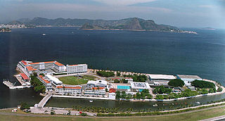
The Federal Center for Technological Education "Celso Suckow da Fonseca", also known as Federal Center for Technological Education of Rio de Janeiro, is one of the most traditional Brazilian federal educational institution subordinated to the Brazilian Ministry of Education. It offers undergraduate and post-graduate level courses in addition to its sought-after technical high school courses.

The Baixada Fluminense is a region in the state of Rio de Janeiro, in southeastern Brazil. It is located on Guanabara Bay, between Rio de Janeiro to the south and the Serra dos Órgãos range of hills to the north.
Villegagnon Island is located near the mouth of the large Guanabara Bay, in the city of Rio de Janeiro, Brazil.

Flamengo Park, also known as Aterro do Flamengo, Eduardo Gomes Park, and Aterro do Brigadeiro Eduardo Gomes, is the largest public park and recreation area within the city of Rio de Janeiro, in eastern Brazil, and the largest urban park by the sea in the world.
Greater Rio de Janeiro, officially the Rio de Janeiro Metropolitan Region is a large metropolitan area located in Rio de Janeiro state in Brazil, the second largest in Brazil and third largest in South America. It consists of 22 municipalities, including the state capital, Rio de Janeiro.

Several years after the Portuguese first explored Brazil, French traders in search of pau-brasil reached the rich area extending from the Cape Frio coast to the beaches and islands of Guanabara Bay, the economic and, above all, strategic importance of which was already well-known.

The South Zone is an area of the city of Rio de Janeiro situated between the Tijuca Massif, the Atlantic Ocean and Guanabara Bay. Most of it is made up of neighborhoods along the Atlantic coastline, such as São Conrado, Vidigal, Leblon, Ipanema, Copacabana, and Leme.
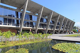
The Museum of Modern Art in Rio de Janeiro (MAM) is a museum located in northeastern Flamengo Park, in the city of Rio de Janeiro, Brazil. It is in the Centro district, west of Santos Dumont Airport, on Guanabara Bay.

Jardim Gramacho is a neighborhood in the city of Duque de Caxias and the state of Rio de Janeiro.

The Legislative Assembly of Rio de Janeiro is the unicameral legislature of Rio de Janeiro, a state in Brazil. It has 70 state deputies elected by proportional representation.

The Port of Rio de Janeiro is a seaport in the city of Rio de Janeiro, Brazil located in a cove on the west shore of Guanabara Bay. It is the third-busiest port in Brazil, and it is managed by Companhia Docas do Rio de Janeiro.
