
The Kaveri is one of the major Indian rivers flowing through the states of Karnataka and Tamil Nadu. The Kaveri River rises at Talakaveri in the Brahmagiri range in the Western Ghats, Kodagu district of the state of Karnataka, at an elevation of 1,341 m above mean sea level and flows for about 800 km before its outfall into the Bay of Bengal. It reaches the sea in Poompuhar, in Mayiladuthurai district. It is the third largest river – after Godavari and Krishna – in southern India, and the largest in the state of Tamil Nadu, which, on its course, bisects the state into north and south. In ancient Tamil literature, the river was also called Ponni.
Mayiladuthurai is a Municipality and district headquarter of Mayiladuthurai district in Tamil Nadu, India. The town is located at a distance of 256 km (159 mi) from the state capital, Chennai.

Perambalur is one of the 38 districts in the state of Tamil Nadu, India. The district headquarters is located at Perambalur. The district occupies an area of 1,752 km2 and had a population of 565,223 with a sex-ratio of 1,003 females for every 1,000 males in 2011.

The Mettur Dam is one of the largest dams in India and also the largest in Tamil Nadu, located across the river Kaveri where it enters the plains. Built in 1934, it took 9 years to complete. Maximum height and width of the dam are 214 and 171 feet, respectively. The dam receives inflows from its own catchment area, Kabini Dam and Krishna Raja Sagara Dams located in Karnataka. There is a park at the base of the dam called Ellis Park maintained by the Tamil Nadu Public Works Department. It provides irrigation and drinking water facilities for more than 12 districts of Tamil Nadu and hence is revered as the life and livelihood-giving asset of Tamil Nadu.

Tiruchirappalli District is one of the 38 districts, located along the Kaveri River, in Tamil Nadu, India. The headquarters of the district is the city of Tiruchirappalli.
Kuruvai, also known as "short-term" in Tamil, are the crops grown in cauvery Delta of Tamil Nadu state in India. The crops that are grown in this delta are mostly paddy and the health of these crops and the eventual livelihood of these farmers are extremely dependent on abundant flow of water on the Cauvery river.
Krishnarayapuram is a panchayat town in Karur district in the Indian state of Tamil Nadu.

Needamangalam (Nidamangalam) formerly Yamunambalpuram, is a town panchayat in Thiruvarur district in the Cauvery Delta of Indian state of Tamil Nadu. Needamangalam was originally part of the composite Tanjore Dist during British Raj until 1997 AD. In the 18th and 19th century, it was also called Yamunambalpuram. Needamangalam is the headquarters of the Needamangalam Taluk. The town is located 20 km east of Thanjavur, 80 km east of Tiruchirappalli and 318 km south of Chennai. Needamangalam is a junction for two busy highways, (i) National Highway 67 is a National Highway in Southern Indian states of Tamil Nadu and Karnataka that runs from Nagapattinam, a sea-side town in Tamil Nadu to Gundlupet, Karnataka (ii) State Highway SH-66 connecting Kumbakonam with Adirampattinam via Mannargudi in Cauvery Delta.
Sholavandan is a panchayat town in Madurai district in the Indian state of Tamil Nadu. It is located on the left bank of the Vaigai River, sixteen miles north west of Madurai. It is one of 12 "town- panchayats" of Madurai district.
Paramathi Velur, a town in Paramathi-Velur taluk, Namakkal District, Tamil Nadu, India is situated just off the Srinagar - Kanyakumari National Highway 44 (India). This town is also called as Paramathi Velur, with STD Code 04268 & Postal code 638182.
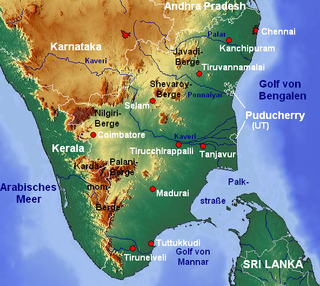
The sharing of waters of the Kaveri River has been the source of a serious conflict between the two Indian states of Tamil Nadu and Karnataka. The genesis of this conflict rests in two agreements in 1892 and 1924 between the Madras Presidency and Kingdom of Mysore. The 802 kilometres (498 mi) Kaveri river has 44,000 km2 basin area in Tamil Nadu and 32,000 km2 basin area in Karnataka. The annual inflow from Karnataka is 425 Tmcft (12 km3) whereas that from Tamil Nadu is 252 TMCft (7.1 km3).
Soorappallam is a village located 1 km away from Pattukkottai town in Thanjavur district in Tamil Nadu state in India on the way to Mannargudi and Kumbakonam via Vadaseri.

Sirkazhi, also spelled as Sirkali and Siyali, is a major municipal town in Mayiladuthurai district in Tamil Nadu, India. It is located 13 km (8.1 mi) from the coast of the Bay of Bengal, and 250 km (160 mi) from the state capital Chennai. Sirkazhi was a part of Thanjavur district until 1991 and has later been part of Nagapattinam district. The town covers an area of 13.21 km2 (5.10 sq mi) and in 2011 had a population of 34,927. It is administered by a second grade municipality. Sirkazhi is part of the Cauvery delta region and agriculture is the major occupation. Roads are the main means of transportation; the town has 51.47 km (31.98 mi) of district roads, including a national highway.
Attur Taluk is one of the taluks, or administrative division of Salem District in the state of Tamil Nadu, India. The division's headquarters is Attur town.
Umayalpuram is a village in the Papanasam taluk of Thanjavur district in the Indian state of Tamil Nadu.
Mannankadu is a village in the Pattukkottai taluk of Thanjavur district, Tamil Nadu, India. It is one of the 32 villages falls under the Musugundan Nadu in the district. Mannangadu is one of the revenue village in its taluk. It is located on state highway Adirampattinam-Mannargudi-Kumbakonam, between Adirampattinam and Madukkur. It is the fourth largest village in Pattukkottai taluk, after Thamarankottai, Thambikottai and Aalathur. Total geographical area of the Village is 1002.02 hectares. The main income source of this village is Agriculture.
Nemmeli is an agricultural village in Madukkur Panchayat Union, Pattukkottai taluk of Thanjavur district, Tamil Nadu, India, also known as 28.Nemmeli. Nemmeli village is division of Musugundha Nadu in Chola nadu. It comes under Pattukottai legislative constituency and Tanjore Parliament constituency. It is a small and well developing village located in the southern part of Tamil Nadu. It is 15 km from Pattukkottai and Mannargudi. It is surrounded with number of villages. Being in the Cauvery River Delta Area the inhabitants’ main occupation is agriculture. The younger generation is well educated, and they are working in various locations in India. They are also working in foreign countries like Singapore, Malaysia, UAE, Saudi Arabia, UK, and USA. The economy is booming in line with India’s rapid economic development. Nemmeli Seawater Desalination Plant located in the township is a major drinking water supply source for South Chennai since 2010.
Poovanam is a village in the Pattukkottai taluk of Thanjavur district, Tamil Nadu, India. It is located in the southern part of the district. It is a peaceful village situated in the Cauvery delta. East area of Poovanam is called Keezhapoovanamand west side area called as Melapoovanam.
Vadiyakkadu is a village in the Madukkur Panchayat Union, Pattukkottai taluk of Thanjavur district, Tamil Nadu, India, also known as Vadiyakkadu. It is a small and well developing Village located in southern part of Tamil Nadu. It is 15 km from Pattukkottai. It is surrounded with number of villages. Being in the Cauvery River Delta Area the inhabitants’ main occupation is agriculture. Tamil is the official language and is predominantly spoken.
Vattakudi-North is an agricultural village in Pattukkottai taluk of Thanjavur district, located in the delta of Cauvery river. Pattukottai is the nearest town, which lies some 10 km to the west. Farming and related activities constitute the core economic drivers of this pastoral village. It comes under Pattukottai legislative constituency and Tanjore Parliament constituency. Vattakudi North is one of the 32 villages of Musugundan Community.