The Ötztal Alps are a mountain range in the Central Eastern Alps, in the State of Tyrol in western Austria and the Province of South Tyrol in northern Italy.

The Central Eastern Alps, also referred to as Austrian Central Alps or just Central Alps, comprise the main chain of the Eastern Alps in Austria and the adjacent regions of Switzerland, Liechtenstein, Italy and Slovenia. South them is the Southern Limestone Alps.

Ortler is, at 3,905 m (12,812 ft) above sea level, the highest mountain in the Eastern Alps outside the Bernina Range. It is the main peak of the Ortler Range. It is the highest point of the Southern Limestone Alps, of South Tyrol in Italy, of Tyrol overall, and, until 1919, of the Austrian-Hungarian empire. In German the mountain is commonly referred to as "König Ortler", like in the unofficial hymn of South Tyrol, the Bozner Bergsteigerlied.

The Ortler Alps are a mountain range of the Southern Limestone Alps mountain group in the Central Eastern Alps, in Italy and Switzerland.
The Adamello-Presanella Alps Alpine group is a mountain range in the Southern Limestone Alps mountain group of the Eastern Alps. It is located in northern Italy, in the provinces of Trentino and Brescia. The name stems from its highest peaks: Adamello and Presanella.

The Livigno Alps are a mountain range in the Alps of eastern Switzerland and northern Italy, around the Italian village Livigno. They are considered to be part of the Central Eastern Alps.
The Sesvenna Alps are a mountain range located in the Alps of eastern Switzerland, northern Italy and western Austria.

The Alps cover a large area. This article describes the delimitation of the Alps as a whole and of subdivisions of the range, follows the course of the main chain of the Alps and discusses the lakes and glaciers found in the region.

Tonale Pass (el. 1883 m./6178 ft.) is a high mountain pass in northern Italy across the Rhaetian Alps, between Lombardy and Trentino.

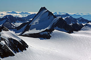
The Zuckerhütl is a mountain in Tyrol, Austria. At 3,505 metres, it is the highest peak of the Stubai Alps and lies at the southern end of the Stubaital Valley.
The Cima del Serraglio is a mountain of the Ortler Alps, located on the border between Italy and Switzerland. It lies between the lake of Livigno (Lombardy) and the Val Mora (Graubünden).

Piz Murtaröl is a mountain of the Ortler Alps, located on the border between Italy and Switzerland. With a height of 3,180 metres above sea level, it is the highest mountain in Val Mora. On its southern side it overlooks Passo di Fraéle.
Piz Tea Fondada is a mountain of the Ortler Alps, located on the border between Italy and Switzerland. On its southern Italian side it overlooks the Lago di Cancano. On its northern Swiss side it overlooks the Val da Tea Fondada, part of the Val Mora.
Piz Minschuns (Romansh) or Schafberg (German) is a mountain in the Fallaschkamm mountains, a subgroup of the Ortler Alps, more precisely on the eastern edge of the Val Costainas, located on the border between Italy and Switzerland.

Hasenöhrl is a mountain of the Ortler Alps in South Tyrol, Italy.

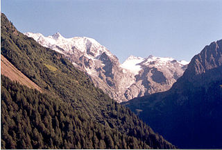
The Königspitze is a mountain of the Ortler Alps on the border between South Tyrol and the Province of Sondrio (Lombardy), Italy. After the Ortler, it is the second highest peak in the Ortler Alps, at a height of 3,851m.

The Alpine Club classification of the Eastern Alps is a common division of the Eastern Alps into 75 mountain ranges, based on the Moriggl Classification (ME) first published in 1924 by the German and Austrian Alpine Club. The present-day division established for the German-speaking world was compiled by the German, Austrian and South Tyrol Alpine Clubs and published in 1984 and is also used for the basic numbering of Alpine Club maps for mountaineering.

The Stelvio Pass is a mountain pass in northern Italy bordering Switzerland at an elevation of 2,757 m (9,045 ft) above sea level. It is the highest paved mountain pass in the Eastern Alps, and the second highest in the Alps, 7 m (23 ft) below France's Col de l'Iseran.

The Große Eiskogel is a mountain in the Ortler Alps in South Tyrol, Italy, which rises to a height of 3,547 m s.l.m..

