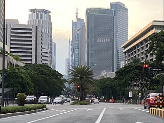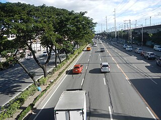
Epifanio de los Santos Avenue, commonly referred to by its acronym EDSA, is a limited-access circumferential highway around Manila, the capital city of the Philippines. It passes through 6 of Metro Manila's 17 local government units or cities, namely, from north to south, Caloocan, Quezon City, San Juan, Mandaluyong, Makati, and Pasay.

The Marquam Bridge is a double-deck, steel-truss cantilever bridge that carries Interstate 5 traffic across the Willamette River from south of downtown Portland, Oregon, on the west side to the industrial area of inner Southeast on the east. It is the busiest bridge in Oregon, carrying 140,500 vehicles a day as of 2016. The upper deck carries northbound traffic; the lower deck carries southbound traffic. The Marquam also has on and off ramps for Interstate 405 on the south end of the bridge, while the terminus on the east bank of the river is near the interchange with Interstate 84.

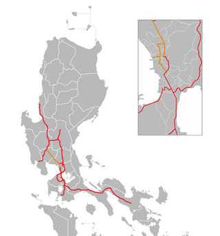
The North Luzon Expressway (NLEX), signed as E1 of the Philippine expressway network, partially as N160 of the Philippine highway network, and partially as R-8 of the Metro Manila arterial road network, is a controlled-access highway that connects Metro Manila to the provinces of the Central Luzon region in the Philippines. The expressway, which includes the main segment and its various spurs, has a total length of 101.8 kilometers (63.3 mi) and travels from its northern terminus at Santa Ines Interchange in Mabalacat, Pampanga, to its southern terminus at Balintawak Interchange in Quezon City, which is adjacent to its connection to Skyway, an elevated toll road that connects the expressway to its counterpart in the south, the South Luzon Expressway. The segment of the expressway between Santa Rita Exit in Guiguinto and the Balintawak Interchangeis part of Asian Highway 26 of the Asian highway network. Although its name implies a connection to northern Luzon, the expressway's northern end is actually in Central Luzon.

The Iloilo River is an estuary river located in the province of Iloilo, in Western Visayas, Philippines. The river starts in Oton at the Batiano estuary, then traverses through the Iloilo City districts of Arevalo, Molo, Mandurriao, La Paz, Lapuz, and the City Proper, before emptying into the Iloilo Strait.

Ayala Avenue is a major thoroughfare in Makati, the Philippines. It is one of the busiest roads in Metro Manila, crossing through the heart of the Makati Central Business District. Because of the many businesses located along the avenue, Ayala Avenue is nicknamed the "Wall Street of the Philippines" and dubbed in the 1970s and 1980s as the "Madison Avenue of the Philippines".

Storrow Drive, officially James Jackson Storrow Memorial Drive, is a major crosstown parkway in Boston, Massachusetts, running east–west along the southern bank of the Charles River. It is restricted to cars; trucks and buses are not permitted on it, while pedestrian access is available via walking paths on the Charles River side of the road. Boston drivers use the route for quick access to downtown locations.

DYOKAksyon Radyo is a radio station owned and operated by MBC Media Group. Its studio is located at the 3rd floor, Carlos Uy Building, Benigno Aquino Avenue corner Diversion Road, Barangay San Rafael, Mandurriao, Iloilo City, while its transmitter is located in Barangay Nabitasan, La Paz, Iloilo City, sharing tower site with sister station DYDH-AM. This station operates daily from 3:45 AM to 11:30 PM.

Batchoy, alternatively spelled batsoy, is a Filipino noodle soup of pork offal, crushed pork cracklings, chicken stock, beef loin, and round noodles. The original and most popular variant, La Paz batchoy, traces its roots to the Iloilo City district of La Paz, in the Philippines.

The Manhattan Waterfront Greenway is a waterfront greenway for walking or cycling, 32 miles (51 km) long, around the island of Manhattan, in New York City. The largest portions are operated by the New York City Department of Parks and Recreation. It is separated from motor traffic, and many sections also separate pedestrians from cyclists. There are three principal parts — the East, Harlem and Hudson River Greenways.

Metropolitan Iloilo–Guimaras, also shortened as Metro Iloilo–Guimaras or Metro Iloilo, or simply MIG, is a metropolitan area in Western Visayas in the Philippines. It is situated on the southeastern coast of Panay, including the nearby island province of Guimaras, surrounded by the Iloilo and Guimaras straits.

The Marikina–Infanta Highway, also known as Marilaque Highway, Marilaque Road, Marikina-Infanta Road, or its former name Marcos Highway, is a 117.5-kilometer (73.0 mi) highway that connects Quezon City, Metro Manila with Infanta, Quezon in the Philippines. Motorists colloquially refer to the road as Marilaque Highway.

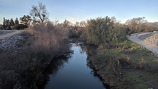
The Guadalupe River Trail is an 11-mile (18 km) pedestrian and bicycle path in the city of San Jose, California. The path runs along the banks of the Guadalupe River. The trail is currently composed of two discontinuous segments: a shorter "upper" segment in the Almaden Valley neighborhood of San Jose and a longer "lower" segment through Downtown San Jose to Alviso. This trail is heavily used for both recreation and commuting, as it provides direct access to Downtown San Jose from many of the outlying neighborhoods. The trail is paved.

The East River Greenway is an approximately 9.44-mile-long (15.19 km) foreshoreway for walking or cycling on the east side of the island of Manhattan on the East River. It is part of the Manhattan Waterfront Greenway. The largest portions are operated by the New York City Department of Parks and Recreation. It is separated from motor traffic, and many sections also separate pedestrians from cyclists. The greenway is parallel to the Franklin D. Roosevelt East River Drive for a majority of its length.

Manuel L. Quezon Avenue, more often called as Quezon Avenue, or simply Quezon Ave, is a 6.1-kilometer (3.8 mi) major thoroughfare in Metro Manila named after President Manuel Luis Quezon, the second president of the Philippines. The avenue starts at the Quezon Memorial Circle and runs through to the Welcome Rotonda near the boundary of Quezon City and Manila.

Iloilo Convention Center (ICON) is a convention center in Iloilo Business Park, in the district of Mandurriao, Iloilo City, Philippines. It stands on the site of Iloilo's former airport, Mandurriao Airport.

The Iloilo River Esplanade is a 9.29-kilometre-long (5.77 mi) urban esplanade and linear park along the Iloilo River in Iloilo City, Philippines. It stretches on both sides of the river, from Carpenter Bridge in Mandurriao and Molo districts to Muelle Loney (Drilon) Bridge in the City Proper and Lapuz districts. It is the longest linear park in the Philippines and was designed by landscape architect and PGAA Creative Design founder Paulo Alcazaren. The project is part of the Iloilo River Rehabilitation Project.

Panay Railways, Inc. is a government-owned and controlled corporation of the Philippines that formerly operated railway systems on the islands of Panay and Cebu. It is headquartered in La Paz, Iloilo City, and is a subsidiary of Phividec Railways, Inc. under the Philippine Veterans Investment Development Corporation (PHIVIDEC). While Panay Railways currently does not operate any trains, it leases its property, and the generated revenue is utilized to cover personnel and administrative costs associated with maintaining its assets.

National Route 5 (N5) forms part of the Philippine highway network. It runs through the province of Capiz to the province of Iloilo, both in the island of Panay. It is the only national primary route in Panay.

Senator Benigno S. Aquino Jr. Avenue, formerly known as Jaro West Diversion Road and still colloquially referred to as Diversion Road, is a major bypass highway in the Iloilo metropolitan area on the island of Panay in the Philippines. It constitutes the southern section of National Route 5, which connects the province of Iloilo to the province of Capiz. The avenue serves as the primary thoroughfare from Iloilo City to Iloilo International Airport and passes through the municipalities of Pavia, Santa Barbara, and Cabatuan. It was named after Benigno "Ninoy" Simeon Aquino Jr., a former senator who played a significant role in opposing the regime of then-President Ferdinand Marcos.
The Carpenter Bridge is a pair of bridges spanning the Iloilo River in Iloilo City, Philippines, consisting of the original bridge, which has been converted into a pedestrian walkway and is part of the Iloilo River Esplanade, and the new bridge, which serves vehicle traffic. It was named after Governor Frank Watson Carpenter, the first civilian governor of the Moro Province in Mindanao.


