Iloilo River

Last updated

Iloilo River
Iloilo River, Muelle Loney capitol (Iloilo City; 10-21-2022).jpg
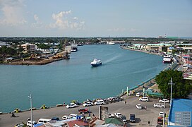
View of the Iloilo River looking towards the Iloilo Provincial Capitol (right)
Philippines relief location map (Visayas).svg
Red pog.svg
Iloilo River mouth
Philippines relief location map (square).svg
Red pog.svg
Iloilo River (Philippines)
Native nameSubâ sang Iloilo (Hiligaynon)
Location
CountryPhilippines
Region Western Visayas
Province Iloilo
City/municipality
Physical characteristics
SourceIloilo-Batiano River Basin
  location Oton
Mouth Iloilo Strait
  location
Iloilo City
  coordinates
10°41′34″N122°35′05″E / 10.69278°N 122.58472°E / 10.69278; 122.58472
Length26.4 km (16.4 mi) [1]
Basin size82.5 sq.kilometres (31.8 sq. miles)
Basin features
ProgressionIloilo River – Iloilo Strait

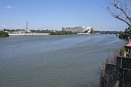
The Iloilo River is an estuary river located in the province of Iloilo, in Western Visayas, Philippines. The river starts in Oton at the Batiano estuary, then traverses through the Iloilo City districts of Arevalo, Molo, Mandurriao, La Paz, Lapuz, and the City Proper, before emptying into the Iloilo Strait.

Contents

As an estuary, the river level fluctuates with the tides. This flow brings in nutrients from the sea, which makes the Iloilo River a nursery for fish species such as bangus and tilapia. The banks of the river are home to 22 of the country's 35 mangrove species, as well as the rare metapenaeus insolitus. [1]

Wharf

The Iloilo River in 1905 Iloilo River (NYPL Hades-2359665-4044430) (page 1 crop).tiff
The Iloilo River in 1905

Iloilo River wharf, including Muelle Loney Street in the Iloilo City Proper, is a natural harbor which made it a preferred port of call for ships seeking protection from strong winds and tropical monsoons. It serves as port for inter island ferries that travel from Iloilo City to Bacolod on Negros and to Guimaras. It is also a drop-off point for fishing vessels that bring in their catch from the sea to be delivered to markets all over Iloilo.

Port

The Port of Iloilo was opened for international trade on 1855 and the coming of British Vice-consul Nicholas Loney, a year later, that led to the fast development of sugar industry in the region.

Esplanade

The Iloilo River Esplanade is a park development stretches on both sides of the river banks constructed as a recreation area and an attraction for visitors. [2]

Bridges

The bridges that cross the river include, into City Proper the Quirino-Lopez Bridge (built 1967, rehabilitated 2000) going to Lapuz district and Forbes (1910, rehabilitated 1975), Jalandoni and Drilon bridges going to La Paz district; and Diversion Bridge (1982) and Carpenter Bridge (2010, replacing a now-pedestrian only bridge) between Mandurriao and Molo districts. [3] [4]

See also

Related Research Articles

<span class="mw-page-title-main">Iloilo</span> Province in Western Visayas, Philippines

Iloilo, also called Iloilo Province, officially the Province of Iloilo, is a province in the Philippines located in the Western Visayas region. Its capital and largest city is Iloilo City, the regional center of Western Visayas and politically independent from the province. Iloilo occupies the southeast portion of the Visayan island of Panay and is bordered by the province of Antique to the west, Capiz to the north, the Jintotolo Channel to the northeast, the Guimaras Strait to the east, and the Iloilo Strait and Panay Gulf to the southwest.

<span class="mw-page-title-main">Iloilo City</span> Highly-urbanized city and capital of Iloilo, Philippines

Iloilo City, officially the City of Iloilo, is a 1st class highly urbanized city in the Western Visayas region of the Philippines, located on the southeastern coast of the island of Panay. According to the 2020 census, Iloilo City has a population of 457,626 people, making it the most populous city in Western Visayas. For the metropolitan area, the total population is 1,007,945 people.

<span class="mw-page-title-main">Mandurriao</span> District of Iloilo City, Philippines

Mandurriao is a district in Iloilo City, Philippines, located in the province of Iloilo, on the island of Panay in the Western Visayas region. It is the second-largest district by geographical area as well as the third-most populous district, with 62,240 people in the 2020 census. Mandurriao is one of the major business districts of Iloilo City, along with Iloilo City Proper.

<span class="mw-page-title-main">Molo, Iloilo City</span> District of Iloilo City, Philippines

Molo is a district in Iloilo City, Philippines, located in the province of Iloilo, on the island of Panay in the Western Visayas region. It is the most densely populated district in the city. According to the 2020 census, Molo has a population of 76,393 people, making it the second-most populous district, after Jaro.

<span class="mw-page-title-main">Iloilo City Proper</span> District of Iloilo City, Philippines

Iloilo City Proper, also known as Downtown Iloilo or simply Iloilo among locals, is an administrative district in Iloilo City, Philippines, located on the southeastern coast of the island of Panay in the Western Visayas region. It serves as the civic center of the city and province of Iloilo, hosting the seat of city and provincial governments, as well as various local, provincial, and regional government offices. According to the 2020 census, it has a population of 46,350 people.

<span class="mw-page-title-main">Arevalo, Iloilo City</span> District of Iloilo City, Philippines

Villa de Arevalo, commonly known as simply Villa or Arevalo, is a district in Iloilo City, Philippines. It is the westernmost district of Iloilo City and shares its border with Oton to the west, in the province of Iloilo, on the island of Panay in the Western Visayas region. According to the 2020 census, it has a population of 55,476 people.

<span class="mw-page-title-main">Metro Iloilo–Guimaras</span> Metropolitan area in the Philippines

Metropolitan Iloilo–Guimaras, also shortened as Metro Iloilo–Guimaras or Metro Iloilo, or simply MIG, is a metropolitan area in Western Visayas in the Philippines. It is situated on the southeastern coast of Panay, including the nearby island province of Guimaras, surrounded by the Iloilo and Guimaras straits.

<span class="mw-page-title-main">Port of Iloilo</span> Port in Philippines

The Port of Iloilo is a seaport located in Iloilo City, Philippines. It serves the city, province of Iloilo, and the entire island of Panay in the Western Visayas region of the Philippines. It is located in the districts of Iloilo City Proper and Lapuz, on the southeastern coast of Panay, in Iloilo Strait, and one of the country’s safest and most natural harbors. The Port of Iloilo is managed by the Philippine Ports Authority, a government-owned corporation, and consists of major facilities: the Iloilo River Wharf, Iloilo Domestic Port, and the Visayas Container Terminal.

<span class="mw-page-title-main">La Paz, Iloilo City</span> District of Iloilo City, Philippines

La Paz is a district in Iloilo City, Philippines, located in Iloilo province, on the island of Panay in the Western Visayas region. It is the third-largest district by geographical area, after Jaro and Mandurriao. According to the 2020 census, it has a population of 54,720 people.

<span class="mw-page-title-main">Lapuz, Iloilo City</span> District of Iloilo City, Philippines

Lapuz is a district in Iloilo City, Philippines, located in the province of Iloilo, on the island of Panay in the Western Visayas region. It is the smallest district by geographical area as well as the least populous district, with 31,747 people in the 2020 census.

<span class="mw-page-title-main">Iloilo Convention Center</span> Convention center in Iloilo City, Philippines

Iloilo Convention Center (ICON) is a convention center in Iloilo Business Park, in the district of Mandurriao, Iloilo City, Philippines. It stands on the site of Iloilo's former airport, Mandurriao Airport.

<span class="mw-page-title-main">Iloilo River Esplanade</span> Linear park in Iloilo City

The Iloilo River Esplanade is a 9.29-kilometre-long (5.77 mi) urban esplanade and linear park along the Iloilo River in Iloilo City, Philippines. It stretches on both sides of the river, from Carpenter Bridge in Mandurriao and Molo districts to Muelle Loney (Drilon) Bridge in the City Proper and Lapuz districts. It is the longest linear park in the Philippines and was designed by landscape architect and PGAA Creative Design founder Paulo Alcazaren. The project is part of the Iloilo River Rehabilitation Project.

<span class="mw-page-title-main">Panay Railways</span> Philippine government corporation

Panay Railways, Inc. is a government-owned and controlled corporation of the Philippines that formerly operated railway systems on the islands of Panay and Cebu. It is headquartered in La Paz, Iloilo City, and is a subsidiary of Phividec Railways, Inc. under the Philippine Veterans Investment Development Corporation (PHIVIDEC). While Panay Railways currently does not operate any trains, it leases its property, and the generated revenue is utilized to cover personnel and administrative costs associated with maintaining its assets.

<span class="mw-page-title-main">Calle Real, Iloilo</span> Historic street and heritage zone in Iloilo City, Philippines

Calle Real, officially named as J.M. Basa Street, is a historic street located in the old downtown district of Iloilo City Proper in Iloilo City, Philippines. It is home to several fine examples of luxury American-era neoclassical, beaux-arts, and art deco buildings. The street has been famous since the Spanish era and once served as the city's main shopping center for more than a century.

<span class="mw-page-title-main">Iloilo Freedom Grandstand</span> Grandstand in Iloilo City, Philippines

The Iloilo Freedom Grandstand, also known as the New Iloilo Freedom Grandstand, is a grandstand located on Muelle Loney Street in Iloilo City Proper, Iloilo City, Philippines. It was built in 2018 as a replacement for the old grandstand with the same name located on Calle Real, which was demolished the same year as part of the revival project of Sunburst Park, where the grandstand used to be located.

<span class="mw-page-title-main">Districts of Iloilo City</span> Conglomeration of former cities and towns

Iloilo City is a conglomeration of former cities and towns in the Philippines, which are now the geographical or administrative districts (boroughs) composed of seven: Arevalo, City Proper, Jaro, La Paz, Lapuz, Mandurriao, and Molo. All administrative districts are divisions of the lone congressional district of Iloilo City, and each is composed of barangays (barrios), with a total of 180 city barangays.

<span class="mw-page-title-main">Iloilo Bridge</span> Bridge in Iloilo City, Philippines

The Iloilo Bridge, also known as Diversion Bridge, is an eight-lane girder bridge spanning the Iloilo River in Iloilo City, Philippines. It was completed in 1982 and connects Benigno S. Aquino Jr. Avenue in the Mandurriao district to the City Proper district.

The Carpenter Bridge is a pair of bridges spanning the Iloilo River in Iloilo City, Philippines, consisting of the original bridge, which has been converted into a pedestrian walkway and is part of the Iloilo River Esplanade, and the new bridge, which serves vehicle traffic. It was named after Governor Frank Watson Carpenter, the first civilian governor of the Moro Province in Mindanao.

<span class="mw-page-title-main">Muelle Loney Street</span> Street in Iloilo City, Philippines

Muelle Loney Street, also known as Iloilo River Wharf, is a street and wharf located in the Iloilo City Proper district of Iloilo City, Philippines. It runs along the south bank of the Iloilo River, stretching from the Muelle Loney (Rizal) Bridge to Fort San Pedro Drive. During the Spanish colonial period, the street served as a prominent wharf and was one of the most important seaports in the Philippines. It played a significant role in the region's sugar industry, facilitating the transportation of sugar and other goods.

The Quirino-Lopez Bridge is a girder bridge that crosses the Iloilo River in Iloilo City, Philippines. It connects the districts of City Proper and Lapuz. Completed in 1967, the bridge spans a southbound canal historically used for sugar transport. The canal also served as a port for sea-going vessels that ferried sugar cane, originating from a facility built by Nicholas Loney in 1926.

References

  1. 1 2 "Iloilo River Protection". www.riversnetwork.org. Rivers Network. Archived from the original on April 20, 2017. Retrieved April 19, 2017.
  2. "Iloilo River Esplanade". Explore Iloilo. Retrieved July 30, 2023.
  3. Pendon, Lydia C. (2012). "Drilon wants name at bridge erased". The Daily Guardian. Archived from the original on March 4, 2016. Retrieved May 12, 2014.
  4. Pendon, Lydia C. (June 10, 2013). "DOT launches 7 Bridges of Blessings in Iloilo City". SunStar Iloilo . Retrieved May 12, 2014.

Further reading