The Euphrates is the longest and one of the most historically important rivers of Western Asia. Together with the Tigris, it is one of the two defining rivers of Mesopotamia. Originating in Turkey, the Euphrates flows through Syria and Iraq to join the Tigris in the Shatt al-Arab in Iraq, which empties into the Persian Gulf.
The Cagayan River, also known as the Río Grande de Cagayán, is the longest river and the largest river by discharge volume of water in the Philippines. It has a total length of approximately 505 kilometres (314 mi) and a drainage basin covering 27,753 square kilometres (10,715 sq mi). It is located in the Cagayan Valley region in northeastern part of Luzon Island and traverses the provinces of Nueva Vizcaya, Quirino, Isabela and Cagayan.

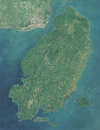
Panay is the sixth-largest and fourth-most populous island in the Philippines, with a total land area of 12,011 km2 (4,637 sq mi) and a total population of 4,542,926, as of 2020 census. Panay comprises 4.4 percent of the entire population of the country. The City of Iloilo is its largest settlement with a total population of 457,626 inhabitants, as of 2020 census.

Iloilo, also called Iloilo Province, officially the Province of Iloilo, is a province in the Philippines located in the Western Visayas region. Its capital and largest city is Iloilo City, the regional center of Western Visayas and politically independent from the province. Iloilo occupies the southeast portion of the Visayan island of Panay and is bordered by the province of Antique to the west, Capiz to the north, the Jintotolo Channel to the northeast, the Guimaras Strait to the east, and the Iloilo Strait and Panay Gulf to the southwest.
Guimaras, officially the Province of Guimaras, is an island province in the Philippines located in the Western Visayas region. The capital is Jordan, while the largest local government unit is the municipality of Buenavista. The province is situated in Panay Gulf, between the islands of Panay and Negros. To the northwest is the city and province of Iloilo and to the southeast is Negros Occidental. The whole island is part of the Metro Iloilo–Guimaras, one of the twelve metropolitan areas of the Philippines.

The Lena is a river in the Russian Far East, and is the easternmost of the three great Siberian rivers that flow into the Arctic Ocean. The Lena is the eleventh-longest river in the world, and the longest river entirely within Russia, with a length of 4,294 km (2,668 mi) and a drainage basin of 2,490,000 km2 (960,000 sq mi). Permafrost underlies most of the catchment, 20% of which is continuous.

The Fitzroy River is a river in Central Queensland, Australia. Its catchment covers an area of 142,665 square kilometres (55,083 sq mi), making it the largest river catchment flowing to the eastern coast of Australia. It is also the largest river basin that discharges onto the Great Barrier Reef.

The Diamantina River is a major river in Central West Queensland and the far north of South Australia.
The Bug or Western Bug is a major river in Central Europe that flows through Belarus (border), Poland, and Ukraine, with a total length of 774 kilometres (481 mi). A tributary of the Narew, the Bug forms part of the border between Belarus and Poland for 178 kilometres (111 mi) and part of the border between Ukraine and Poland for 185 kilometres (115 mi).

Iloilo City, officially the City of Iloilo, is a 1st class highly urbanized city in the Western Visayas region of the Philippines, located on the southeastern coast of the island of Panay. According to the 2020 census, Iloilo City has a population of 457,626 people, making it the most populous city in Western Visayas. For the metropolitan area, the total population is 1,007,945 people.

Santa Barbara, officially the Municipality of Santa Barbara, is a 2nd class municipality in the province of Iloilo, Philippines. According to the 2020 census, it has a population of 67,630 people.

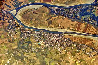
The Iloilo River is an estuary river located in the province of Iloilo, in Western Visayas, Philippines. The river starts in Oton at the Batiano estuary, then traverses through the Iloilo City districts of Arevalo, Molo, Mandurriao, La Paz, Lapuz, and the City Proper, before emptying into the Iloilo Strait.

The Panay River is the longest river on Panay Island in the Philippines, with a total length of approximately 152 kilometres (94 mi) and a drainage basin area of 2,203.76 square kilometres (850.88 sq mi). It drains almost the entire province of Capiz and northern portion of Iloilo province.

Molo is a district in Iloilo City, Philippines, located in the province of Iloilo, on the island of Panay in the Western Visayas region. It is the most densely populated district in the city. According to the 2020 census, Molo has a population of 76,393 people, making it the second-most populous district, after Jaro.

Villa de Arevalo, commonly known as simply Villa or Arevalo, is a district in Iloilo City, Philippines. It is the westernmost district of Iloilo City and shares its border with Oton to the west, in the province of Iloilo, on the island of Panay in the Western Visayas region. According to the 2020 census, it has a population of 55,476 people.

The Jalaur River, also known as Jalaud River, is the second longest river on Panay island in the Philippines, with a total length of 123 km (76 mi) and the second largest by drainage basin after Panay River in Capiz. The Jalaur has a drainage area of 1,503 square kilometres (580 sq mi). Its source is in the Central Panay Mountain Range, west of Calinog, and the river traverses east to southeast before emptying into the Guimaras Strait. It drains the eastern portion of Panay and courses through Passi City and the towns of Leganes, Zarraga, Dumangas, Barotac Nuevo, Pototan, Dingle, San Enrique, Dueñas, and Calinog, all in Iloilo province.

La Paz is a district in Iloilo City, Philippines, located in Iloilo province, on the island of Panay in the Western Visayas region. It is the third-largest district by geographical area, after Jaro and Mandurriao. According to the 2020 census, it has a population of 54,720 people.

Cross River is the main river in southeastern Nigeria and gives its name to Cross River State. It originates in Cameroon, where it takes the name of the Manyu River. Although not long by African standards its catchment has high rainfall and it becomes very wide. Over its last 80 kilometres (50 mi) to the sea it flows through swampy rainforest with numerous creeks and forms an inland delta near its confluence with the Calabar River, about 20 kilometres (12 mi) wide and 50 kilometres (31 mi) long between the cities of Oron on the west bank and Calabar, on the east bank, more than 30 kilometres (19 mi) from the open sea. The delta empties into a broad estuary which it shares with a few smaller rivers. At its mouth in the Atlantic Ocean, the estuary is 24 kilometres (15 mi) wide. The eastern side of the estuary is in the neighboring country of Cameroon.

The Iloilo River Esplanade is a 9.29-kilometre-long (5.77 mi) urban esplanade and linear park along the Iloilo River in Iloilo City, Philippines. It stretches on both sides of the river, from Carpenter's Bridge in Mandurriao and Molo districts to Muelle Loney (Drilon) Bridge in the City Proper and Lapuz districts. It is the longest linear park in the Philippines and was designed by landscape architect and PGAA Creative Design founder Paulo Alcazaren. The project is part of the Iloilo River Rehabilitation Project.
The Dominique River is a river in the Côte-Nord region of Quebec, Canada. It empties into the Gulf of Saint Lawrence.