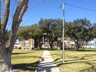
Brooks County is a county in Texas, and Falfurrias is its county seat. Its population was 7,076, about 88% Latino per the 2020 census. It is one of Texas's poorest counties.

A border checkpoint is a location on an international border where travelers or goods are inspected and allowed passage through. Authorization often is required to enter a country through its borders. Access-controlled borders often have a limited number of checkpoints where they can be crossed without legal sanctions. Arrangements or treaties may be formed to allow or mandate less restrained crossings. Land border checkpoints can be contrasted with the customs and immigration facilities at seaports, international airports, and other ports of entry.
Interstate 605 is a 27-mile-long (43 km) major north–south auxiliary Interstate Highway in the Greater Los Angeles urban area of Southern California. It runs from I-405 and State Route 22 (SR 22) in Seal Beach to I-210 in Duarte. The San Gabriel River Freeway closely parallels the San Gabriel River for most of its alignment, hence its name, which is one of the few Southern California freeways not named after a city along its route.
Interstate 580 (I-580) is an approximately 76-mile-long (122 km) east–west auxiliary Interstate Highway in Northern California. The heavily traveled spur route of I-80 runs from US Route 101 (US 101) in San Rafael in the San Francisco Bay Area to I-5 at a point outside the southern city limits of Tracy in the Central Valley. I-580 forms a concurrency with I-80 between Albany and Oakland, the latter of which is the location of the MacArthur Maze interchange immediately east of the San Francisco–Oakland Bay Bridge. I-580 provides a connection from the Bay Area to the southern San Joaquin Valley and Southern California via I-5, as I-5 bypasses the Bay Area to the east.

Route 110, consisting of State Route 110 (SR 110) and Interstate 110 (I-110), is a state and auxiliary Interstate Highway in the Los Angeles metropolitan area of the US state of California. The entire route connects San Pedro and the Port of Los Angeles with Downtown Los Angeles and Pasadena. The southern segment from San Pedro to I-10 in downtown Los Angeles is signed as I-110, while the northern segment to Pasadena is signed as SR 110. The entire length of I-110, as well as SR 110 south of the Four Level Interchange with US Route 101 (US 101), is the Harbor Freeway, and SR 110 north from US 101 to Pasadena is the historic Arroyo Seco Parkway, the first freeway in the western United States.
State Route 85 is a state highway which connects the cities of southern San Jose and Mountain View in the U.S. State of California. The highway intersects with major highways such as I-280, SR 17, and SR 87. The route serves as a bypass of U.S. Route 101 in the Santa Clara Valley area, running through the foothill cities of Los Gatos, Saratoga, Cupertino, roughly paralleling the Santa Cruz Mountains up to its interchange with I-280.

The United States border with Mexico is one of the world's "most lethal land borders". Hundreds of migrants die per year as they attempt to cross into the United States from Mexico illegally. The US Border Patrol reported 251 migrant deaths in the fiscal year 2015, which was lower than any year during the period 2000–2014, and reported 247 migrant deaths in fiscal year 2020, lower than any year since 1998. Poverty, gang violence, poor governance, etc. are the main factors as to why migrants cross the US border. US Border Patrol recorded 557 southwest border deaths during fiscal year 2021 and 748 in the first 11 months of fiscal year 2022, the most deaths ever recorded.

State Route 87, known as the Guadalupe Freeway or referred to by the locals as Highway 87, is a north–south state highway in San Jose, California, United States. Before being upgraded to a freeway, it was Guadalupe Parkway.

The Foothill Freeway is a freeway in the Los Angeles metropolitan area, California, United States, running from the Sylmar district of Los Angeles east to Redlands. The western segment is signed as Interstate 210 (I-210) from its western end at I-5 to SR 57 in Glendora, while the eastern segment is signed as State Route 210 (SR 210) to its eastern terminus at I-10. Under the California Streets and Highways Code, the entire Foothill Freeway is legally referred to as Route 210.
State Route 905 (SR 905), also known as the Otay Mesa Freeway, is an 8.964-mile-long (14.426 km) state highway in San Diego, in the southwestern part of the U.S. state of California. It connects I-5 and I-805 in San Ysidro to the Mexican border at Otay Mesa. The entire highway from I-5 to the international border is a freeway with a few exits that continues east from the I-805 interchange before turning southeast and reaching the border.
State Route 71 (SR 71) is a 15-mile (24 km) state highway in the U.S. state of California. Serving Riverside, San Bernardino, and Los Angeles counties, it runs from SR 91 in Corona to the Kellogg Interchange with I-10 and SR 57 on the border of Pomona and San Dimas. The segment from SR 91 to SR 83 in Chino Hills is called the Corona Freeway, formerly the Corona Expressway and before then the Temescal Freeway. SR 71 is designated as the Chino Valley Freeway between SR 83 and the Kellogg Interchange.

State Route 7 is a state highway in the U.S. state of California, running from the Calexico East Port of Entry on the U.S.-Mexico border east of Calexico north to its terminus at Interstate 8 (I-8), where Orchard Road continues the route north towards Holtville. The route provides convenient access to the country of Mexico from I-8. The southern portion of the route opened in 1996, and the rest of the route connecting to I-8 opened in 2005.

State Route 11 (SR 11) is a state highway in the U.S. state of California. The first phase of the highway opened in 2016, connecting SR 125 and SR 905 with Enrico Fermi Drive in the Otay Mesa area of San Diego. It is planned to be extended from Enrico Fermi Drive to the proposed U.S.–Mexico border crossing at Otay Mesa East. There are also plans for an interchange at Siempre Viva Road and to convert the highway to a toll road once the entire route is completed. Planning for the road began in the 1990s, and construction started in 2013.

State Route 4 is a state highway in the U.S. state of California, routed from Interstate 80 in the San Francisco Bay Area to State Route 89 in the Sierra Nevada. It roughly parallels the Sacramento-San Joaquin River Delta, a popular area for boating and fishing, with a number of accesses to marinas and other attractions. After crossing the Central Valley, the highway ascends up the Sierra foothills. It passes through Ebbetts Pass and contains the Ebbetts Pass Scenic Byway, a National Scenic Byway.

The Mexico–United States border is an international border separating Mexico and the United States, extending from the Pacific Ocean in the west to the Gulf of Mexico in the east. The border traverses a variety of terrains, ranging from urban areas to deserts. The Mexico–U.S. border is the most frequently crossed border in the world with approximately 350 million documented crossings annually. It is the tenth-longest border between two countries in the world.

U.S. Route 101 (US 101) is a major north–south United States Numbered Highway, stretching from Los Angeles, California, to Tumwater, Washington. The California portion of US 101 is one of the last remaining and longest U.S. Routes still active in the state, and the longest highway of any kind in California. US 101 was also one of the original national routes established in 1926. Significant portions of US 101 between the Los Angeles area and the San Francisco Bay Area follow El Camino Real, the commemorative route connecting the former Alta California's 21 missions.

Interstate 5 (I-5) is a major north–south route of the Interstate Highway System in the United States, stretching from the Mexican border at the San Ysidro crossing to the Canadian border near Blaine, Washington. The segment of I-5 in California runs 796.77 miles (1,282.28 km) across the length of the state from San Ysidro to the Oregon state line south of the Medford-Ashland metropolitan area. It is the longest interstate in California, and accounts for more than half of I-5's total length.
The United States Border Patrol operates 71 traffic checkpoints, including 33 permanent traffic checkpoints, near the Mexico–United States border. The stated primary purpose of these inspection stations is to deter illegal immigration and smuggling activities. After the September 11 attacks in 2001, they took on the additional role of terrorism deterrence. These checkpoints are located between 25 and 75 miles of the Mexico–United States border along major U.S. highways; near the southern border of the contiguous United States. Their situation at interior locations allow them to deter illegal activities that may have bypassed official border crossings along the frontier. The checkpoints are divided among nine Border Patrol sectors. There are a number of these checkpoints near the northern border of the contiguous U.S. as well, within 100 miles (160 km) of the Canada–U.S. border.

The international border between Finland and Russia is 1,340 km (830 mi) long and runs approximately north to south, mostly through taiga forests and sparsely populated rural areas. It does not follow any natural landmarks, such as rivers. It is also an external border of the European Union and NATO.

The 2015 Amado checkpoint protest took place on May 27, 2015, when approximately seventy-five protesters held a demonstration at the United States Border Patrol checkpoint along Arivaca Road in Amado, Arizona, about 35 miles south of Tucson.


