
Guam is an organized, unincorporated territory of the United States in the Micronesia subregion of the western Pacific Ocean. It is the westernmost point and territory of the United States; in Oceania, it is the largest and southernmost of the Mariana Islands and the largest island in Micronesia. Guam's capital is Hagåtña, and the most populous city is Dededo.

Guam is a U.S. territory in the western Pacific Ocean, at the boundary of the Philippine Sea. It is the southernmost and largest member of the Mariana Islands archipelago, which is itself the northernmost group of islands in Micronesia. The closest political entity is the Commonwealth of the Northern Mariana Islands (CNMI), another U.S. territory. Guam shares maritime boundaries with CNMI to the north and the Federated States of Micronesia to the south. It is located approximately one quarter of the way from the Philippines to Hawaii. Its location and size make it strategically important. It is the only island with both a protected harbor and land for multiple airports between Asia and Hawaii, on an east-west axis, and between Papua New Guinea and Japan, on a north-south axis.
Hassan, Hasan, Hassane, Haasana, Hassaan, Asan, Hassun, Hasun, Hassen, Hasson or Hasani may refer to:

Hagåtña is the capital village of the United States territory of Guam. From the 18th through mid-20th century, it was Guam's population center, but today it is the second smallest of the island's 19 villages in both area and population. However, it remains one of the island's major commercial districts in addition to being the seat of government.

Apra Harbor, also called Port Apra, is a deep-water port on the western side of the United States territory of Guam. It is considered one of the best natural ports in the Pacific Ocean. The harbor is bounded by Cabras Island and the Glass Breakwater to the north and the Orote Peninsula in the south. Naval Base Guam and the Port of Guam are the two major users of the harbor. It is also a popular recreation area for boaters, surfers, scuba divers, and other recreationalists.

The Battle of Guam was the American recapture of the Japanese-held island of Guam, a U.S. territory in the Mariana Islands captured by the Japanese from the U.S. in the 1941 First Battle of Guam during the Pacific campaign of World War II.

The Roman Catholic Archdiocese of Agaña is an ecclesiastical territory or diocese of the Catholic Church in the United States. It comprises the United States dependency of Guam. The prelate is an archbishop whose cathedral is the Dulce Nombre de Maria Cathedral-Basilica.

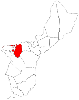
Agat is a village in the United States territory of Guam. It is located south of Apra Harbor on the island's western shore. The village's population has decreased since the island's 2000 census.
Piti is a village located on the central west coast of the United States territory of Guam. It contains northern and eastern coastlines of Apra Harbor, including Cabras Island, which has the commercial Port of Guam and the island's largest power plants. Piti was a pre-Spanish CHamoru village and, after Spanish colonization, became the primary port town on Guam. The town was largely destroyed during the 1944 liberation of Guam and the population relocated during the wartime construction of Apra Harbor.

Yona is a village in the United States territory of Guam.

The War in the Pacific National Historical Park is a multi-unit protected area in the United States territory of Guam, which was established in 1978 in honor of those who participated in the Pacific Theater of World War II. Uniquely among the National Park System, it honors the bravery and sacrifices of all those who participated in the Pacific Theater.

Mount Lamlam is a peak on the United States island of Guam. It is located near the village of Agat, in the south-west of the island.
Mount Jumullong Manglo is a peak in the south-west of the island of the United States territory of Guam.
Fena Lake (Reservoir) is the largest lake in the United States territory of Guam and it is a man made reservoir. It is located in the south of the island on the Ordnance Annex military installation, and is overlooked by the nearby peaks of Mounts Lamlam, Alifan and Jumullong Manglo. The lake's outflow is to the north-west, its waters eventually reaching the Pacific Ocean at Talofofo Bay.

The U.S. unincorporated territory of Guam first required its residents to register their motor vehicles and display license plates in 1916.
The Talofofo River is one of the longest rivers on the Pacific Ocean island of Guam. Rising on the eastern slopes of Mount Lamlam in the island's south-west, it traverses the island in a north-eastward direction, flowing into the sea at Talofofo Bay.

USS Guam (CB-2) was an Alaska-class large cruiser which served with the United States Navy during the end of World War II. She was the second and last ship of her class to be completed. The ship was the second vessel of the US Navy to be named after the island of Guam, an American territory in the Pacific. Due to her commissioning late in the war, Guam saw relatively limited service during the war. She participated in operations off Okinawa in March–July 1945, including providing anti-aircraft defense for the carrier task force and conducting limited shore bombardment operations. She participated in sweeps for Japanese shipping in the East China and Yellow Seas in July–August 1945. After the end of the war, she assisted in the occupation of Korea and transported a contingent of US Army troops back to the United States. She was decommissioned in February 1947 and placed in reserve, where she remained until she was stricken in 1960 and sold for scrapping the following year.
Mount Bolanos is a south-west peak in the United States territory of Guam.

The geology of Guam formed as a result of mafic, felsic and intermediate composition volcanic rocks erupting below the ocean, building up the base of the island in the Eocene, between 33.9 and 56 million years ago. The island emerged above the water in the Eocene, although the volcanic crater collapsed. A second volcanic crater formed on the south of the island in the Oligocene and Miocene. In the shallow water, numerous limestone formations took shape, with thick alternating layers of volcanic material. The second crater collapsed and Guam went through a period in which it was almost entirely submerged, resembling a swampy atoll, until structural deformation slowly uplifted different parts of the island to their present topography. The process of uplift led to widespread erosion and clay formation, as well as the deposition of different types of limestone, reflecting different water depths.

