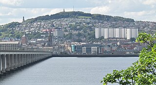
Dundee is the fourth-largest city in Scotland. The mid-year population estimate for 2016 was 148,210, giving Dundee a population density of 2,478/km2 or 6,420/sq mi, the second-highest in Scotland. It lies within the eastern central Lowlands on the north bank of the Firth of Tay, which feeds into the North Sea. Under the name of Dundee City, it forms one of the 32 council areas used for local government in Scotland. Within the boundaries of the historic county of Angus, the city developed into a burgh in the late 12th century and established itself as an important east coast trading port. Rapid expansion was brought on by the Industrial Revolution, particularly in the 19th century when Dundee was the centre of the global jute industry. This, along with its other major industries, gave Dundee its epithet as the city of "jute, jam and journalism".

South Africa occupies the southern tip of Africa, its coastline stretching more than 2,850 kilometres from the desert border with Namibia on the Atlantic (western) coast southwards around the tip of Africa and then northeast to the border with Mozambique on the Indian (eastern) coast. The low-lying coastal zone is narrow for much of that distance, soon giving way to a mountainous escarpment that separates the coast from the high inland plateau. In some places, notably the province of KwaZulu-Natal in the east, a greater distance separates the coast from the escarpment. Although much of the country is classified as semi-arid, it has considerable variation in climate as well as topography. The total land area is 1,220,813 km2 (471,359 sq mi). It has the 23rd largest Exclusive Economic Zone of 1,535,538 km2 (592,875 sq mi).

KwaZulu-Natal is a province of South Africa that was created in 1994 when the government merged the Zulu bantustan of KwaZulu and Natal Province.

The Drakensberg is the eastern portion of the Great Escarpment, which encloses the central Southern African plateau. The Great Escarpment reaches its greatest elevation – 2,000 to 3,482 metres within the border region of South Africa and Lesotho.
Ingwavuma is a town in the Umkhanyakude District Municipality of KwaZulu-Natal Province, South Africa. It is unclear where the name of the town came from; one theory is that it was named after the Ngwavuma River while another is that there was a leader called Vuma, the name then meaning "Vuma's place" in Zulu. Trees found on the river bank are also named Ngwavuma but it is unclear which entity was named after which. It is over 700 metres above sea level in the Lebombo Mountains and boasts several highly scenic spots. The town is three kilometres from the country's border with Eswatini and overlooks the plains of Maputaland to the East.

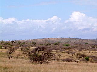
The coal mining town of Dundee is situated in a valley of the Biggarsberg mountains in KwaZulu-Natal, South Africa. It is part of the Endumeni Municipality, Umzinyathi District. It is very rich in coal deposits. More populous than the town of Dundee is its adjacent township named Sibongile. This township is now being extended with many residing zones, e.g. Lindelani.
Kokstad is a town in the Harry Gwala District Municipality of KwaZulu-Natal Province, South Africa. Kokstad is named after the Griqua chief Adam Kok III who settled here in 1863. Kokstad is the capital town of the East Griqualand region, as it is also the biggest town in this region. It was built around Mount Currie, a local mountain range, by the city's founder Adam Kok III, for whom the town is named. Stad is the Dutch and Afrikaans word for "city".
Port Edward is a small resort town situated on the south coast of KwaZulu-Natal in South Africa and lies on the border between KwaZulu-Natal and the Eastern Cape. It is situated on the R61 road between Port Shepstone and Lusikisiki.

Newcastle is the third-largest city in the province of KwaZulu-Natal, South Africa and is the province's industrial centre. The city has four industrial areas. Newcastle is known as the "New City" The majority of its citizens reside in Newcastle East in the main townships of Madadeni and Osizweni, with the balance residing in Newcastle West. Set at the foothills of the northern KwaZulu-Natal Drakensberg Mountains, Newcastle is located in the northwest corner of the province along the Ncandu River.
Utrecht is a town in the foothills of the Balele Mountains, in the northwestern corner of KwaZulu-Natal, South Africa. Newcastle, Kwazulu-Natal's third-largest urban centre, is 50 km from Utrecht. Utrecht has a population of approximately 32,000.
Hluhluwe is a small town in northern KwaZulu-Natal, South Africa. It is situated between iSimangaliso Wetland Park and Hluhluwe–iMfolozi Park on the banks of the Hluhluwe River. Hluhluwe is situated on the elephant coast, an area known for its national parks, natural diversity and cultural heritage. Although relatively undeveloped the area is of growing interest to international tourists and travelers. Several local and international movies have been filmed in Hluhluwe, such as I Dreamed of Africa,Ghost Son, and documentaries filmed in the surrounding national parks.

The Battle of Talana Hill, also known as the Battle of Glencoe, was the first major clash of the Second Boer War. A frontal attack by British infantry supported by artillery drove Boers from a hilltop position, but the British suffered heavy casualties in the process, including their commanding general Sir William Penn Symons.

Dundee Law is a hill in the centre of Dundee, Scotland, and is the highest point in the city. The Law is what remains of a volcanic sill, which is the result of volcanic activity around 400 million years ago. With a large war memorial at its summit, it is the most prominent feature on the local skyline.

Prehistoric Park is a six-part nature docu-fiction television series that premiered on ITV on 22 July 2006 and on Animal Planet on 29 October 2006. The programme was produced by Impossible Pictures, who also created Walking with Dinosaurs. Each episode is an hour long including commercial breaks. Repeats of the show are broadcast in the UK on Watch.

Willamette Valley is an American Viticultural Area (AVA) which lies in the Willamette Valley of Oregon. The AVA is the wine growing region which encompasses the drainage basin of the Willamette River. It stretches from the Columbia River in the north to just south of Eugene in the south, where the Willamette Valley ends; and from the Oregon Coast Range in the west to the Cascade Mountains in the east. At 5,360 square miles, it is the largest AVA in the state, and contains most of the state's wineries; approximately 908 as of 2021.

The Dundee Hills AVA is an American Viticultural Area located in Yamhill County, Oregon. It is entirely contained within the Willamette Valley AVA, and is approximately 28 miles (45 km) southwest of Portland, near the towns of Dundee and Dayton. The area is 6,940 acres (2,809 ha) in total size, with 1,300 acres (526 ha) planted with grapes. The Dundee Hills are a north-south oriented line of hills on the western side of the Willamette River valley. The soil is red in color, rich in iron, relatively infertile, making it suitable for grape cultivation. The region gets 30 inches (76 cm) to 45 inches (114 cm) of rainfall per year. The Chehalem Mountains to the north protect the region from the cool breezes that enter Willamette Valley from the Columbia Gorge. Over 25 wineries and independent vineyards in this region produce over 44,000 cases of wine.

The Zulu Kingdom, sometimes referred to as the Zulu Empire or the Kingdom of Zululand, was a monarchy in Southern Africa. During the 1810s, Shaka established a standing army that consolidated rival clans and built a large following which ruled a wide expanse of Southern Africa that extended along the coast of the Indian Ocean from the Tugela River in the south to the Pongola River in the north.
Nquthu is a town in Umzinyathi District Municipality in the KwaZulu-Natal province of South Africa.
Talana is a village 5 km east of Dundee on the route between Vryheid and Glencoe. The name is Zulu and derives from the shelf, made of itala grass, around the central pole in a Zulu chief's home. Amulets, precious items and valuables were placed on this Talana Shelf. Hence the name means "the place where treasures are kept."
