
Dhankuta District is one of 14 districts of Koshi Province of eastern Nepal. The district covers an area of 891 km2 (344 sq mi) and has a population (2011) of 163,412. The hill town of Dhankuta serves as the district headquarters of Dhankuta District.

Khotang District is one of 14 districts of Koshi Province of eastern Nepal. The district, with Diktel as its district headquarters, covers an area of 1,591 km2 (614 sq mi) and has a population (2021) of 206,312. The district is bordered by Bhojpur District in the east, Udayapur District in the south, Okhaldhunga District in the west and Solukhumbu District in the North. In this district there are two municipalities and eight rural/urban municipalities.

Okhaldhunga District is one of 14 districts of Koshi Province in eastern Nepal. The district, with the municipality of Okhaldhunga as its district headquarters, covers an area of 1,074.5 km2 (414.9 sq mi) and had a population of 156,702 in 2001 and 147,984 in 2011.
Ramechhap District, a part of Bagmati Province, is a district of Nepal. The district, also known as Wallo Kirat Ramechhap, has its district headquarters in Manthali and covers an area of 1,546 km2 (597 sq mi). In 2011, the district had a population of 202,646 and population density of 137.4 per km2. It has 11 post offices, with the District Post Office bearing the postal code 45400.

Nar is a village development committee in Manang District in the Gandaki Zone of northern Nepal. In the 2011 Nepal census it had a population of 362 people, living in 86 individual households.
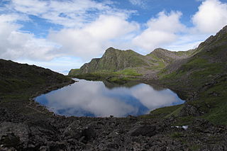
Baku is a village development committee (VDC) in Solukhumbu District in the Sagarmatha Zone of north-eastern Nepal. Baku lies in the Himalaya, 59 km South of Mount Everest and is bordered by the valleys of the Dudh Kosi River (West) and Hinku Drangka River (East). At the time of the 1991 Nepal census it had a population of 4159 people living in 777 individual households. At the time of the 2011 census, the population of the VDC Baku was 4844 inhabitants in 963 individual households.
Bung is a village development committee in Solukhumbu District in the Sagarmatha Zone of north-eastern Nepal. At the time of the 1991 Nepal census it had a population of 3368 people living in 737 individual households. At the 2011 census, the population of Bung was 4520 inhabitants in 982 individual households. Bung lies in the Himalaya mountains, 54 km South of Mount Everest and is bordered by the Hunku Drangka (East). Gudel lies on the other side of the valley of Bung.
Bhagawanpur is a Village Development Committee in Siraha District in the Sagarmatha Zone of south-eastern Nepal. At the time of the 1991 Nepal census it had a population of 2845 people residing in 455 individual households.
Barsain is a village development committee in Saptari District in the Sagarmatha Zone of south-eastern Nepal. At the time of the 2011 Nepal census it had a population of 5458 people living in 991 individual households.
Bathnaha is a village development committee in Saptari District in the Sagarmatha Zone of south-eastern Nepal. At the time of the 2011 Nepal census it had a population of 5,011 people living in 1,180 individual households.
Belhi Chapena is a village development committee in Saptari District in the Sagarmatha Zone of south-eastern Nepal. At the time of the 2011 Nepal census it had a population of 5,807 people living in 1105 individual households.
Bhutahi is a village development committee in Saptari District in the Sagarmatha Zone of south-eastern Nepal. At the time of the 2011 Nepal census it had a population of 4,016 people living in 785 individual households.
Bishariya is a village development committee in Saptari District in the Sagarmatha Zone of south-eastern Nepal. At the time of the 2011 Nepal census, it had a population of 7,120 people living in 1,410 individual households.
Dauda is a village development committee in Saptari District in the Sagarmatha Zone of south-eastern Nepal. At the time of the 2011 Nepal census it had a population of 6,290 people living in 1,049 individual households.
Dhanagadi is a village development committee in Saptari District in the Sagarmatha Zone of south-eastern Nepal. At the time of the 2011 Nepal census it had a population of 5,201 people living in 954 individual households.
Ko. Madhepura is a village development committee in Saptari District in the Sagarmatha Zone of south-eastern Nepal. At the time of the 2011 Nepal census it had a population of 4,608.
Lalapati is a village development committee in Saptari District in the Sagarmatha Zone of south-eastern Nepal. At the time of the 2011 Nepal census it had a population of 5,509 people living in 996 individual households. After newly formed lower administrative division, Lalapati belongs to Chhinnamasta Gaunpalika as Ward No.4. lalapatti laleswarnath mahadev

Mahadeva is a rural municipality formerly, village development committee in Saptari District in the Sagarmatha Zone of south-eastern Nepal. It is located on the eastern side of the district headquarter Rajbiraj. At the time of the 2011 Nepal census it had a population of 5,187 people living in 1,135 individual households.
Maina Sahasrabahu is a village in Khadak Municipality in Saptari District in the Sagarmatha Zone of South-Eastern Nepal. It is the former Village Development Committee of Nepal. At the time of the 2011 Nepal census, it had a population of 4,047 people living in 779 individual households.
Malekpur is a village development committee in Saptari District in the Sagarmatha Zone of south-eastern Nepal. At the time of the 2011 Nepal census it had a population of 6,601 people living in 1,258 individual households.

