
Salem is a historic coastal city in Essex County, Massachusetts, located on the North Shore of Greater Boston. Continuous settlement by Europeans began in 1626 with English colonists. Salem would become one of the most significant seaports trading commodities in early American history.

The Port of Boston is a major seaport located in Boston Harbor and adjacent to the City of Boston. It is the largest port in Massachusetts and one of the principal ports on the East Coast of the United States.

The Salem Maritime National Historic Site is a National Historic Site consisting of 12 historic structures, one replica tall-ship, and about 9 acres of land along the waterfront of Salem Harbor in Salem, Massachusetts. Salem Maritime is the first National Historic Site established in the United States. It interprets the Triangle Trade during the colonial period, in cotton, rum, sugar and slaves; the actions of privateers during the American Revolution; and global maritime trade with the Far East, after independence. The National Park Service manages both the National Historic Site and a Regional Visitor Center in downtown Salem. The National Park Service (NPS) is an agency of the United States Department of the Interior.

The Port of San Francisco is a semi-independent organization that oversees the port facilities at San Francisco, California, United States. It is run by a five-member commission, appointed by the Mayor and approved by the Board of Supervisors. The Port is responsible for managing the larger waterfront area that extends from the anchorage of the Golden Gate Bridge, along the Marina district, all the way around the north and east shores of the city of San Francisco including Fisherman's Wharf and the Embarcadero, and southward to the city line just beyond Candlestick Point. In 1968 the State of California, via the California State Lands Commission for the State-operated San Francisco Port Authority, transferred its responsibilities for the Harbor of San Francisco waterfront to the City and County of San Francisco / San Francisco Harbor Commission through the Burton Act AB2649. All eligible State port authority employees had the option to become employees of the City and County of San Francisco to maintain consistent operation of the Port of San Francisco.

Boston Harborwalk is a public walkway that follows the edge of piers, wharves, beaches, and shoreline around Boston Harbor. When fully completed it will extend a distance of 47 miles (76 km) from East Boston to the Neponset River.
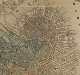
Milk Street is a street in the financial district of Boston, Massachusetts, which was one of Boston's earliest highways. The name "Milk Street" was most likely given to the street in 1708 due to a milk market at the location, although Grace Croft's 1952 work "History and Genealogy of Milk Family" instead proposes that Milk Street may have been named for John Milk, an early shipwright in Boston. The land was originally conveyed to his father, also John Milk, in October 1666.
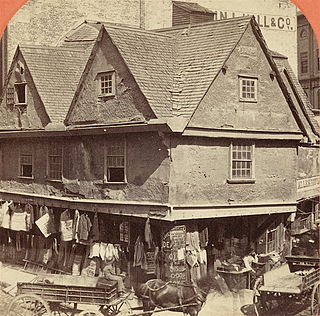
The Old Feather Store (1680–1860) was a shop located at Dock Square and North Street in Boston, Massachusetts, in the 17th–19th centuries. It was also called the Old Cocked Hat. Built in 1680 by Thomas Stanbury, it was demolished in 1860.

Federal Street is a street in the Financial District of Boston, Massachusetts. Prior to 1788, it was known as Long Lane. The street was renamed after state leaders met there in 1788 to determine Massachusetts' ratification of the United States Constitution.

Congress Street in Boston, Massachusetts, is located in the Financial District and South Boston. It was first named in 1800. It was extended in 1854 as far as Atlantic Avenue, and in 1874 across Fort Point Channel into South Boston. Today's Congress Street consists of several segments of streets, previously named Atkinson's Street, Dalton Street, Gray's Alley, Leverett's Lane, Quaker Lane, and Shrimpton's Lane.

North Square in the North End of Boston, Massachusetts, USA, sits at the intersection of Moon, Prince, North, Garden Court and Sun Court Streets. Paul Revere lived here, as did other notables in the 17th and 18th centuries. Prior to July 4, 1788, the area was known as Clark's Square.

Merchants Row in Boston, Massachusetts is a short street extending from State Street to Faneuil Hall Square in the Financial District. Since the 17th century it has been a place of commercial activity. It sits close to Long Wharf and Dock Square, hubs of shipping and trade through the 19th century. Portions of the street were formerly known as Swing-Bridge Lane, Fish Lane, and Roebuck Passage.

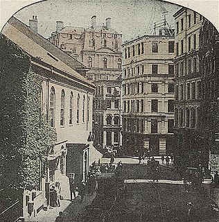
Cornhill was a street in Boston, Massachusetts, in the 18th, 19th and 20th centuries, located on the site of the current City Hall Plaza in Government Center. It was named in 1829; previously it was known as Market Street (1807–1828). In its time, it comprised a busy part of the city near Brattle Street, Court Street and Scollay Square. In the 19th century, it was the home of many bookstores and publishing companies. As of 1969, Cornhill exists as 144 feet along the edge of City Hall Plaza.

The Park Theatre (est.1879) was a playhouse in Boston, Massachusetts, in the late 19th and early 20th centuries. It later became the State cinema. Located on Washington Street, near Boylston Street, the building existed until 1990.

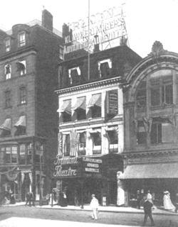
The Globe Theatre (est.1871) was a playhouse in Boston, Massachusetts, in the 19th century. It was located at 598 Washington Street, near the corner of Essex Street. Arthur Cheney oversaw the Globe until 1876. From 1871-1873 it occupied the former theatre of John H. Selwyn. After a fire in May 1873, the Globe re-opened on the same site in December 1874. Architect Benjamin F. Dwight designed the new building. From 1877-1893 John Stetson served as proprietor; some regarded him as "a theatrical producer with a reputation for illiteracy in his day such as Samuel Goldwyn has achieved" in the 1960s. The theatre burned down in January 1894.
The Tremont Theatre was a playhouse in Boston, Massachusetts, in the late 19th and early 20th centuries. Henry E. Abbey and John B. Schoeffel established the enterprise and oversaw construction of its building at no.176 Tremont Street in the Boston Theater District area. Managers included Abbey, Schoeffel and Grau, Klaw & Erlanger, Thos. B. Lothan and Albert M. Sheehan.

Grundmann Studios (1893–1917) in Boston, Massachusetts, was a building on Clarendon Street in the Back Bay. It contained artist's workspaces and multipurpose function rooms Copley Hall and Allston Hall. Prior to 1893, it functioned as a skating rink; after the Boston Art Students' Association leased the building it was renamed in honor of local art educator Emil Otto Grundmann. The Massachusetts Institute of Technology, whose campus was adjacent, owned the property. Tenants included the Copley Society ; artists Henry R. Blaney, Herman Dudley Murphy, Frank Richmond, Mary Bradish Titcomb; sculptor John A. Wilson, architect Josephine Wright Chapman; and the College Club. The structure existed until 1917, when it was demolished to allow for the extension of Stuart St., part of the "broad highway" civic improvement project.

The Boston Evening Traveller (1845–1967) was a newspaper published in Boston, Massachusetts. It was a daily newspaper, with weekly and semi-weekly editions under a variety of Traveller titles. It was absorbed by the Boston Herald in 1912, and ceased publication in 1967.
The Seaport District, or simply the Seaport, is a neighborhood in Boston, Massachusetts. It is part of the larger neighborhood of South Boston, and is also sometimes called the Innovation District. The Seaport is a formerly industrial area that has undergone an extensive redevelopment effort in recent years. It is bordered by the Fort Point Channel to the west, Boston Harbor to the north and east, and the historic residential neighborhood of South Boston to the south. It is officially referred to by the City of Boston as The South Boston Waterfront. The Seaport District is at extreme risk of climate-related flooding over the next 30 years.
Lewis Wharf is a showpiece of waterfront urban renewal in Boston's historic North End. The granite structures on the wharf were built as an early 19th-century shopping mall in the era before railroads when water transport was the most efficient way to move commodities to marketplaces.

Central Wharf is a historic pier in Boston, Massachusetts. Built in 1815–1816 between Long Wharf and India Wharf, it originally extended from India Street nearly a quarter-mile into Boston Harbor. Today, the much-shortened wharf serves as the home of the New England Aquarium.


