Indian Creek (Elwha River)

Last updated

Indian Creek is a tributary of the Elwha River located in Washington in the United States.

Tributary stream or river that flows into a main stem river or lake

A tributary or affluent is a stream or river that flows into a larger stream or main stem river or a lake. A tributary does not flow directly into a sea or ocean. Tributaries and the main stem river drain the surrounding drainage basin of its surface water and groundwater, leading the water out into an ocean.

Elwha River river in the United States of America

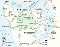
The Elwha River is a 45-mile (72 km) river on the Olympic Peninsula in the U.S. state of Washington. From its source at Elwha snowfinger in the Olympic Mountains, it flows generally north to the Strait of Juan de Fuca. Most of the river's course is within the Olympic National Park.

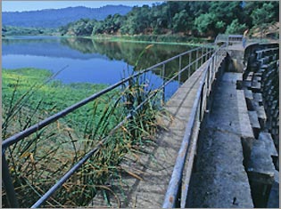
Indian Creek flows from Lake Sutherland into the former Lake Aldwell. Historically, Indian Creek supported runs of several anadromous salmon and trout species, including all five species of Pacific Salmon. However, with construction of the Elwha Dam in 1913, fish were blocked from accessing the Pacific Ocean.

Lake Sutherland is located on the Olympic Peninsula about 17 miles (27 km) west of Port Angeles, Washington. The lake is located just to the east of Lake Crescent. Lake Sutherland drains into Indian Creek, which is a tributary of the Elwha River.

Lake Aldwell lake of the United States of America

Lake Aldwell was a reservoir located about 4.9 miles (7.9 km) from the mouth of the Elwha River on the Olympic Peninsula in the state of Washington. The reservoir was created in 1913 behind the Elwha Dam, which was fully removed in 2012. The Elwha Dam blocked 70+ miles of fish habitat for Pacific Salmon and steelhead within Olympic National Park.

Salmon Family of fish related to trout

Salmon is the common name for several species of ray-finned fish in the family Salmonidae. Other fish in the same family include trout, char, grayling and whitefish. Salmon are native to tributaries of the North Atlantic and Pacific Ocean. Many species of salmon have been introduced into non-native environments such as the Great Lakes of North America and Patagonia in South America. Salmon are intensively farmed in many parts of the world.

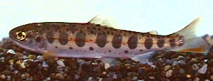
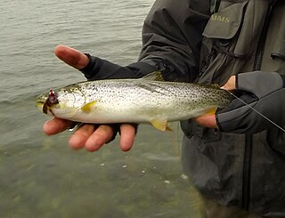
While the Elwha Dam was in operation, Indian Creek sustained populations of kokanee sockeye salmon, which spawned in Lake Sutherland and migrated to Lake Aldwell to use as their ocean. It also contained stream resident coastal rainbow trout, coastal cutthroat trout, and introduced eastern brook trout.

Sockeye salmon species of fish

Sockeye salmon, also called red salmon, kokanee salmon, or blueback salmon, is an anadromous species of salmon found in the Northern Pacific Ocean and rivers discharging into it. This species is a Pacific salmon that is primarily red in hue during spawning. They can grow up to 84 cm in length and weigh 2.3 to 7 kg (5–15 lb). Juveniles remain in freshwater until they are ready to migrate to the ocean, over distances of up to 1,600 km (1,000 mi). Their diet consists primarily of zooplankton. Sockeye salmon are semelparous, dying after they spawn. Some populations, referred to as kokanee, do not migrate to the ocean and live their entire lives in freshwater.

Rainbow trout species of trout

The rainbow trout is a trout and species of salmonid native to cold-water tributaries of the Pacific Ocean in Asia and North America. The steelhead is an anadromous (sea-run) form of the coastal rainbow trout(O. m. irideus) or Columbia River redband trout (O. m. gairdneri) that usually returns to fresh water to spawn after living two to three years in the ocean. Freshwater forms that have been introduced into the Great Lakes and migrate into tributaries to spawn are also called steelhead.

Coastal cutthroat trout subspecies of fish

The coastal cutthroat trout also known as the sea-run cutthroat trout, or harvest trout is one of the several subspecies of cutthroat trout found in Western North America. The coastal cutthroat trout occurs in four distinct forms. A semi-anadromous or sea-run form is the most well known. Freshwater forms occur in both large and small rivers and streams and lake environments. The native range of the coastal cutthroat trout extends south from the southern coastline of the Kenai Peninsula in Alaska to the Eel River in Northern California. Coastal cutthroat trout are resident in tributary streams and rivers of the Pacific basin and are rarely found more than 100 miles (160 km) from the ocean.

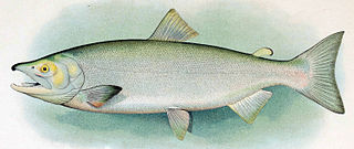
With the removal of the Elwha Dam in 2012, the native salmonids began a return to their anadromous lifestyle, with spawning activities of true anadromous Chinook salmon observed in late 2013. [1]

Salmonidae family of fishes

Salmonidae is a family of ray-finned fish, the only living family currently placed in the order Salmoniformes. It includes salmon, trout, chars, freshwater whitefishes, and graylings, which collectively are known as the salmonids. The Atlantic salmon and trout of the genus Salmo give the family and order their names.

Chinook salmon species of fish

The Chinook salmon is the largest species in the Pacific salmon genus Oncorhynchus. The common name refers to the Chinookan peoples. Other vernacular names for the species include king salmon, Quinnat salmon, spring salmon, chrome hog, and Tyee salmon. The scientific species name is based on the Russian common name chavycha (чавыча).

See also

Related Research Articles

Fish migration Movement of fishes from one part of a water body to another on a regular basis

Many types of fish migrate on a regular basis, on time scales ranging from daily to annually or longer, and over distances ranging from a few metres to thousands of kilometres. Fish usually migrate to feed or to reproduce, but in other cases the reasons are unclear.

Olympic Peninsula peninsula

The Olympic Peninsula is the large arm of land in western Washington that lies across Puget Sound from Seattle, and contains Olympic National Park. It is bounded on the west by the Pacific Ocean, the north by the Strait of Juan de Fuca, and the east by Hood Canal. Cape Alava, the westernmost point in the contiguous United States, and Cape Flattery, the northwesternmost point, are on the peninsula. Comprising about 3600 square miles, the Olympic Peninsula contained many of the last unexplored places in the Contiguous United States. It remained largely unmapped until Arthur Dodwell and Theodore Rixon mapped most of its topography and timber resources between 1898 and 1900.

<i>Oncorhynchus masou</i> species of fish

Oncorhynchus masou, known as the masu salmon, masu, or the cherry hybrid salmon, is a species of salmon found in the northern part of the Pacific Ocean along East Asia, ranging from the Kamchatka, Kuril Islands, Sakhalin, and Primorsky Krai south through Korea, Taiwan, and Japan. A number of subspecies are known, including the anadromous, widespread masu Oncorhynchus masou masou, the critically endangered, landlocked Taiwanese or Formosan salmon Oncorhynchus masou formosanus found in certain freshwater systems of Taiwan, the Biwa trout endemic of Lake Biwa, and the anadromous or stream-dwelling amago Oncorhynchus masou macrostomus restricted to western Japan.

Atlantic salmon species of fish

The Atlantic salmon is a species of ray-finned fish in the family Salmonidae. It is found in the northern Atlantic Ocean, in rivers that flow into the north Atlantic and, due to human introduction, in the north Pacific Ocean. Atlantic salmon have long been the target of recreational and commercial fishing, and this, as well as habitat destruction, has reduced their numbers significantly; the species is the subject of conservation efforts in several countries.

Arctic char species of fish

Arctic char or Arctic charr is a cold-water fish in the family Salmonidae, native to alpine lakes and arctic and subarctic coastal waters. Its distribution is circumpolar. It spawns in fresh water and populations can be lacustrine, riverine or anadromous, where they return from the ocean to their fresh water birth rivers to spawn. No other freshwater fish is found as far north; it is, for instance, the only fish species in Lake Hazen on Ellesmere Island in the Canadian Arctic. It is one of the rarest fish species in Britain and Ireland, found mainly in deep, cold, glacial lakes, and is at risk from acidification. In other parts of its range, such as the Nordic countries, it is much more common, and is fished extensively. In Siberia, it is known as golets and it has been introduced in lakes where it sometimes threatens less hardy endemic species, such as the small-mouth char and the long-finned char in Elgygytgyn Lake.

Sea trout subspecies of brown trout

Sea trout is the common name usually applied to anadromous forms of brown trout, and is often referred to as Salmo trutta morpha trutta. Other names for anadromous brown trout are sewin (Wales), peel or peal, mort, finnock (Scotland), white trout (Ireland) and salmon trout (culinary). The term sea trout is also used to describe other anadromous salmonids—coho salmon, brook trout, Arctic char, cutthroat trout and Dolly Varden. Even some non-salmonid species are also commonly known as sea trout—Northern pikeminnow and members of the weakfish family (Cynoscion).

Pink salmon species of fish

Pink salmon or humpback salmon is a species of anadromous fish in the salmon family. It is the smallest and most abundant of the Pacific salmon. The scientific species name is based on the Russian common name for this species gorbúša (горбуша), which literally means humpie.

Arctic lamprey species of chordates

The Arctic lamprey is a species of lamprey, a jawless fish in the order Petromyzontiformes. It inhabits coastal freshwater habitat types in the Arctic. Some populations are anadromous, spending part of their lives in the ocean. It is the most common and widespread lamprey in the Arctic region.

Elwha Dam

The Elwha Dam was a 108-ft high dam located in the United States, in the state of Washington, on the Elwha River approximately 4.9 miles (7.9 km) upstream from the mouth of the river on the Strait of Juan de Fuca.

Lake Mills (Washington) lake of the United States of America

Lake Mills was a reservoir in Olympic National Park, Washington, United States, that existed from 1927 to 2012. It was formed by the Glines Canyon Dam on the Elwha River and was located about 13 miles from the mouth of the river on the Olympic Peninsula.

Dam removal

Dam removal is the process of demolishing a dam, leaving a river to flow freely. It is undertaken for a variety of reasons that include environmental rehabilitation, structural weakness and maintenance expense.

Elwha Ecosystem Restoration

The Elwha Ecosystem Restoration Project is a 21st-century project of the U.S. National Park Service to remove two dams on the Elwha River on the Olympic Peninsula in Washington state, and restore the river to a natural state. It is the largest dam removal project in history and the second largest ecosystem restoration project in the history of the National Park Service, after the Restoration of the Everglades. The controversial project, costing about $351.4 million, has been contested and periodically blocked for decades. It has been supported by a major collaboration among the Lower Elwha Klallam Tribe, and federal and state agencies.

Searsville Dam

Searsville Dam is a masonry dam in San Mateo County, California that was completed in 1892, one year after the founding of Stanford University, and impounds Corte Madera Creek to form a reservoir known as Searsville Lake. Searsville Dam is located in the Jasper Ridge Biological Preserve and is owned and operated by Stanford University. Neighboring cities include Woodside and Portola Valley, California.

The Lower Elwha Klallam Tribe is a federally recognized Native American nation in the Pacific Northwest of the United States. The tribe is part of the larger Klallam culture, part of the Coast Salish peoples.

References

  1. Gussman, John. "Going Home". Return of the River. Retrieved 1 November 2013.

Coordinates: 48°04′01″N123°34′56″W / 48.06694°N 123.58222°W / 48.06694; -123.58222

Geographic coordinate system Coordinate system

A geographic coordinate system is a coordinate system that enables every location on Earth to be specified by a set of numbers, letters or symbols. The coordinates are often chosen such that one of the numbers represents a vertical position and two or three of the numbers represent a horizontal position; alternatively, a geographic position may be expressed in a combined three-dimensional Cartesian vector. A common choice of coordinates is latitude, longitude and elevation. To specify a location on a plane requires a map projection.