Lake Michigan is one of the five Great Lakes of North America. It is the second-largest of the Great Lakes by volume and the third-largest by surface area, after Lake Superior and Lake Huron. To the east, its basin is conjoined with that of Lake Huron through the narrow Straits of Mackinac, giving it the same surface elevation as its easterly counterpart; the two are technically a single lake.

Wisconsin is a U.S. state in the north-central, Midwest and Great Lakes regions of the country. It is bordered by Minnesota to the west, Iowa to the southwest, Illinois to the south, Lake Michigan to the east, Michigan to the northeast, and Lake Superior to the north. Wisconsin is the 23rd-largest state by total area and the 20th-most populous. The state capital is Madison, and its largest city is Milwaukee, which is on the western shore of Lake Michigan. The state is divided into 72 counties.

The Midwest League is a Minor League Baseball league, established in 1947 and based in the Midwestern United States. It is classified as a Class A-Advanced league.
The Hocągara (Ho-Chungara) or Hocąks (Ho-Chunks) are a Siouan-speaking Indian Nation originally from Wisconsin and northern Illinois. Due to forced emigration in the 19th century, they now constitute two individual tribes; the Ho-Chunk Nation of Wisconsin and the Winnebago Tribe of Nebraska. They are most closely related to the Chiwere peoples, and more distantly to the Dhegiha.

The Midwestern United States, often referred to simply as the Midwest, is one of four census regions of the United States Census Bureau. It occupies the northern central part of the United States. It was officially named the North Central Region by the Census Bureau until 1984. It is between the Northeastern United States and the Western United States, with Canada to its north and the Southern United States to its south.

Elkhart Lake is a village in Sheboygan County, Wisconsin, United States, located within the northwestern part of the county within the Town of Rhine. The population was 967 at the 2010 census. It is included in the Sheboygan, Wisconsin Metropolitan Statistical Area. Elkhart Lake may be best known for hosting road races on public county roads during the 1950s, later moving to a dedicated race track called Road America, which is located a few miles south of the village.

Eagle River is a city in Vilas County, Wisconsin, United States. The population was 1,398 at the 2010 census. It is the county seat of Vilas County. Because of the many lakes in the area, the city is a popular vacation and retirement destination. The area contains many condominiums, seasonal vacation homes, and hunting cabins.

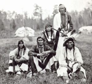
The Ojibwe, Ojibwa, Chippewa, or Saulteaux are an Anishinaabe people of southern Canada and the northern Midwestern United States. In the United States, they have the fifth-largest population among Native American peoples, surpassed in number only by the Navajo, Cherokee, Choctaw and Sioux. In Canada, they are the second-largest First Nations population, surpassed only by the Cree. They are one of the most numerous indigenous peoples north of the Rio Grande.

Oconomowoc is a city in Waukesha County, Wisconsin, United States. The name was derived from Coo-no-mo-wauk, the Potawatomi term for "waterfall." The population was 15,712 at the 2010 census. The city is partially adjacent to the Town of Oconomowoc and near the village of Oconomowoc Lake, Wisconsin.

The Potawatomi, also spelled Pottawatomi and Pottawatomie, are a Native American people of the Great Plains, upper Mississippi River, and western Great Lakes region. They traditionally speak the Potawatomi language, a member of the Algonquin family. The Potawatomi call themselves Neshnabé, a cognate of the word Anishinaabe. The Potawatomi are part of a long-term alliance, called the Council of Three Fires, with the Ojibway and Odawa (Ottawa). In the Council of Three Fires, the Potawatomi are considered the "youngest brother" and are referred to in this context as Bodéwadmi, a name that means "keepers of the fire" and refers to the council fire of three peoples.
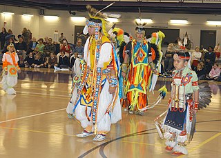
The Ho-Chunk, also known as Hoocągra or Winnebago, are a Siouan-speaking Native American people whose historic territory includes parts of Wisconsin, Minnesota, Iowa, and Illinois. Today, Ho-Chunk people are enrolled in two federally recognized tribes, the Ho-Chunk Nation of Wisconsin and the Winnebago Tribe of Nebraska.

The Menominee are a federally recognized nation of Native Americans, with a 353.894 sq mi (916.581 km2) reservation in Wisconsin. Their historic territory originally included an estimated 10 million acres (40,000 km2) in present-day Wisconsin and the Upper Peninsula of Michigan. The tribe currently has about 8,700 members.

In the U.S. state of Wisconsin, the Lake Superior Lowland, also known as the Superior Coastal Plain, is a geographical region located in the far northern part of the state bordering Lake Superior. It covers about 1,250 square miles (3,200 km2), and does not extend beyond 20 miles (32 km) from the Lake Superior shore.
The Bad River LaPointe Band of the Lake Superior Tribe of Chippewa Indians are a federally recognized tribe of Ojibwe people. The Bad River Reservation is located on the south shore of Lake Superior and has a land area of 156,000 acres in northern Wisconsin straddling Ashland and Iron counties. The tribe has approximately 7,000 members, of whom about 1,800 lived on the reservation during the 2000 census.
The Fond du Lac Indian Reservation is an Indian reservation in northern Minnesota near Cloquet in Carlton and Saint Louis counties. Off-reservation holdings are located across the state in Douglas County, in the northwest corner of Wisconsin. The total land area of these tribal lands is 153.8375 square miles (398.437 km2). It is the land-base for the Fond du Lac Band of Lake Superior Chippewa. Before the establishment of this reservation, the Fond du Lac Band of Lake Superior Chippewa were located at the head of Lake Superior, closer to the mouth of the Saint Louis River, where Duluth has developed.
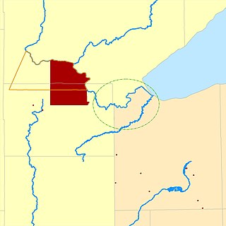
The Lac Courte Oreilles Tribe is one of six federally recognized bands of Ojibwe people located in present-day Wisconsin. The band is based at the Lac Courte Oreilles Indian Reservation, at 45°52′59″N91°19′13″W in northwestern Wisconsin, which surrounds Lac Courte Oreilles. The main reservation's land is in west-central Sawyer County, but two small plots of off-reservation trust land are located in Rusk, Burnett, and Washburn counties. The Reservation was established in 1854 by the second Treaty of La Pointe.

The Door Peninsula is a peninsula in eastern Wisconsin, separating the southern part of the Green Bay from Lake Michigan. The peninsula includes northern Brown and Kewaunee counties and all of Door County. It is the western portion of the Niagara Escarpment. Well known for its cherry and apple orchards, the Door Peninsula is a popular tourism destination. With the 1881 completion of the Sturgeon Bay Ship Canal, the northern half of the peninsula became an island.

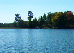
Lac Vieux Desert is a lake in the United States divided between Gogebic County, Michigan, and Vilas County, Wisconsin. Fed primarily by springs in the surrounding swamps, it is the source of the Wisconsin River, which flows out of its southwest corner. The lake contains a number of small islands, especially in its northeastern lobe, including Draper Island in Michigan and Duck Island, in Wisconsin.

The St. Croix Chippewa Indians of Wisconsin are a Federally recognized Indian Tribe, located in northwestern Wisconsin, along the St. Croix River valley and watershed.

The Summer Island Site, designated 20DE4, is an archaeological site located on the northwest side of Summer Island, in Delta County, Michigan. It is classified as a stratified, multi-component site with Middle Woodland, Upper Mississippian and Early Historic/Protohistoric occupations. It was listed on the National Register of Historic Places in 1971.