U.S. Route 35 (US 35) is a United States Highway that runs southeast–northwest for approximately 412 miles (663 km) from the western suburbs of Charleston, West Virginia to northern Indiana. Although the highway is physically southeast–northwest, it is nominally north–south. The highway's southern terminus is in Scott Depot, West Virginia, at Interstate 64 (I-64). Its northern terminus is in Michigan City, Indiana, at US 20. Currently, the West Virginia portion of the highway is being expanded to four lanes, mostly along a completely new route. The Ohio portion has already been upgraded to a four-lane highway/freeway between the West Virginia state line and Trotwood, west of Dayton.
U.S. Route 224 (US 224) is a spur of US 24 that runs through the states of Indiana, Ohio and Pennsylvania. It currently runs for 289 miles (465 km) from Huntington, Indiana. at US 24 to New Castle, Pennsylvania, at US 422 Business and Pennsylvania Route 18 (PA 18). It goes through the cities of Canfield, Ohio, Akron, Ohio, and Findlay, Ohio. In Northeast Ohio, US 224 is located a short distance north of the Western Reserve's southern boundary.

State Road 26 is an east–west discontinuous state road in the central part of the US state of Indiana. The western end of the western segment is at the Illinois border, where it continues as Illinois Route 9. The highway passes through rural areas of Warren and Tippecanoe counties, before ending near West Lafayette. The eastern segment begins at an interchange with Interstate 65 (I-65) and heads east passing through the cities of Kokomo, Hartford City, and Portland, before ending at the Ohio border, where it continues east as Ohio State Route 119. The road covers a distance of about 150.1 miles (241.6 km), passing through mostly rural areas.

State Road 70 in the U.S. state of Indiana consists of two discontinuous east–west segments of two-lane rural roadway. State Road 70 passes through no cities or towns of significant size.

State Road 5 (SR 5) is a north–south state road in the US state of Indiana. Its southern terminus is at SR 22 in Upland, and the northern terminus is at SR 120 just north of Shipshewana. The state road runs for just over 96 miles (154 km), passing through five counties in northern Indiana, mostly through rural farm fields and small towns. The largest city along its path is Huntington. It is entirely a surface highway that is very rural outside of the towns. SR 5 runs along two dams the first being J. Edward Roush Lake Dam and the second being the Wilmot Dam.
Interstate 65 (I-65) in the U.S. state of Indiana traverses from the south-southeastern Falls City area bordering Louisville, Kentucky, through the centrally located capital city of Indianapolis, to the northwestern Calumet Region of the Hoosier State which is part of the Chicago metropolitan area. The Indiana portion of I-65 begins in Jeffersonville after crossing the Ohio River and travels mainly north, passing just west of Columbus prior to reaching the Indianapolis metro area. Upon reaching Indianapolis, the route alignment of I-65 begins to run more to the northwest and subsequently passes Lafayette on that city's east and north sides. Northwest of there, in west-central Jasper County, the route again curves more northward as it approaches the Calumet Region. Shortly after passing a major junction with I-80 and I-94, I-65 reaches its northern national terminus in Gary at I-90 which is carried on the Indiana East–West Toll Road. I-65 covers 261.27 miles (420.47 km) in the state of Indiana. This is one of the principal interstate highways that cross the state, and, more specifically, intersect at the city of Indianapolis, that has given the state the nickname of "Crossroads of America".

State Route 109 (SR 109) is a 52.94-mile (85.20 km) state route that runs between Ottawa and the Michigan state line in the US state of Ohio. It crosses a major river, the Maumee, east of Napoleon. Most of the route is a rural two-lane highway and passes through both farmland and residential properties.
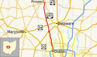
State Route 257 is a 26.19-mile (42.15 km) north - south state highway in the central portion of the U.S. state of Ohio. The highway's southern terminus is in the northwestern Columbus suburb of Dublin at a roundabout intersection with U.S. Route 33 and SR 161. This mainly two-lane highway follows the eastern side of the Scioto River from Dublin to its junction with US 42. After crossing over the river with the U.S. highway, SR 257 parallels the river's western bank. SR 257 has its northern terminus at a T-intersection with SR 47 on the western village limits of Prospect. SR 257 was created in 1926, and extended in 1935 and 1937.

New York State Route 166 (NY 166) is a north–south state highway in Otsego County, New York, in the United States. It extends for 20.96 miles (33.73 km) from NY 28 in the village of Milford to U.S. Route 20 (US 20) north of the village of Cherry Valley. Much of NY 166's southern portion is near Cooperstown, and various county routes serve as connectors between NY 166 and Cooperstown. In Cherry Valley, NY 166 intersects the former western terminus of the First Great Western Turnpike. After passing under US 20, the road continues as County Route 32, which becomes County Route 82 at the Montgomery County line, north to Sprout Brook in Montgomery County, where it meets NY 163. NY 166 is a two-lane highway its entire length.

State Road 63 (SR 63) in the U.S. state of Indiana is a north–south route in the western portion of the state. Until mid-2008, it covered a distance of just over 96 miles (154 km), but now is a discontinuous route. For 63 miles (101 km), from the city of Terre Haute until it rejoins U.S. Route 41 (US 41) near Carbondale, it is a four-lane divided highway and replaces US 41 as the major north–south artery in this portion of the state.
U.S. Route 50 (US 50) is a part of the United States Numbered Highway System that runs from West Sacramento, California, to Ocean City, Maryland. In the U.S. state of Indiana, it is part of the state road system. US 50 enters the state in Vincennes. The 171.38 miles (275.81 km) of US 50 that lie within Indiana serve as a major conduit. All of the highway is listed on the National Highway System. Various sections are rural two-lane highway, urbanized four-lane undivided highway and one-way streets. The easternmost community along the highway is Lawrenceburg at the Ohio state line. US 50 passes through urban areas, farmland and woodland.

State Road 116 is a State Road in the northern section of the US state of Indiana. Running for about 32 miles (51 km) in a general southeast-northwest direction and it is signed east-west. The road connects Markle, Bluffton, and Geneva and passes through mostly farmland outside of cities and towns. SR 116 was originally introduced in the early 1930s routed between Markle and SR 3 north of Bluffton. The road was extended southeast to U.S. Highway 27 in the late 1930s and early 1940s. In the mid-1940s the road was extended east to the Ohio state line, near New Corydon. This extension was removed between late 1990s and early 2000s, the east end of SR 116 was truncated to its current location at US 27.

State Route 111 (SR 111) is a 31.49-mile (50.68 km) state route that runs between the Indiana state line and Defiance in the US state of Ohio. Most of the route is a rural two-lane highway and passes through both farmland and residential properties. For some of its path, SR 111 runs generally parallel to the north of the Auglaize River.

State Route 644 is a north–south state highway running through Columbiana and Carroll counties in northeast Ohio. Its southern terminus is at SR 39 in downtown Salineville, and its northern terminus is at its junction with U.S. Route 30(US 30) and SR 9 in the center of Kensington. The route connects mainly rural and a few unincorporated parts of southeastern Columbiana County. SR 644 only briefly passes into a corner of Carroll County for a 0.41-mile (0.66 km) journey.

State Route 282 is a north–south state highway in northeastern Ohio, a U.S. state. The southern terminus of SR 282 is at a T-intersection with SR 305 near the hamlet of Nelson. Its northern terminus is also at a T-intersection, this time with the four-lane divided U.S. Route 422 (US 422) approximately two miles (3.2 km) southeast of Parkman. SR 282 primarily serves as an access route for Nelson Kennedy Ledges State Park. For its duration, the highway is also known as Nelson Ledge Road.
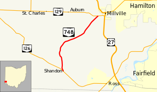
State Route 748 is a north–south state highway in southwestern Ohio, a U.S. state. Situated in west-central Butler County, SR 748 has its southern terminus at SR 126 in the unincorporated community of Shandon. Its northern terminus is at SR 129 near Millville, just one-half mile (0.80 km) west of SR 129's junction with U.S. Route 27.

U.S. Route 6 is a part of the United States Numbered Highway System that runs from Bishop, California to Provincetown, Massachusetts. US 6 is the second longest federal highway in the United States, second only to U.S. Route 20. In Ohio, the road runs west-east from the Indiana state line near Edgerton to the Pennsylvania state line near Andover. The 248.002 miles (399.121 km) that lie in Ohio are maintained by the Ohio Department of Transportation (ODOT). US 6 serves the major cities of Sandusky, Lorain, and Cleveland. The highway is also called the Grand Army of the Republic Highway to honor the Union forces of the American Civil War. The alternate name was designated in 1953.

US Highway 127 (US 127) is a part of the United States Numbered Highway System that runs from Chattanooga, Tennessee, to the Lower Peninsula of Michigan. In Ohio, the highway runs 194.27 miles (312.65 km) from the Ohio River in Cincinnati to the Michigan state line north of West Unity. US 127 runs south to north in Ohio's westernmost counties along the border of Indiana. The highway is a main route connecting many small towns, including eight county seats. The highway was first designated in 1926. Its route ended in downtown Toledo before being realigned to its current route in 1930.

State Route 216 is a north–south state highway in the southeastern quadrant of the U.S. state of Ohio. The southern terminus of SR 216 is at a three-way stop T-intersection with SR 78 in Murray City. SR 216's northern terminus is also at a three-way stop T-intersection, this time with SR 93 in New Straitsville.
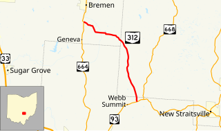
State Route 312 (SR 312) is a north–south state highway located in the southern portion of the U.S. state of Ohio. SR 312 runs from its southern terminus at a T-intersection with SR 93 approximately 4.25 miles (6.84 km) northeast of Logan to its northern terminus at a T-intersection with SR 664 nearly 1.25 miles (2.01 km) south of Bremen.