Indiana State Road 165

Last updated

Indiana 165.svg

State Road 165
Map of Indiana State Road 165.svg
Route information
Maintained by INDOT
Length 17.172 mi [1] (27.636 km)
Major junctions
South endIndiana 66.svg SR 66 at Wadesville
 I-64.svg I-64
North endIndiana 65.svg SR 65 at Owensville
Location
Counties Gibson, Posey
Highway system
Indiana 164.svg SR 164 SR 166 Indiana 166.svg

State Road 165 is a 17-mile (27 km) route in Gibson and Posey counties in the U.S. State of Indiana.

Gibson County, Indiana County in the United States

Gibson County is a county in the southwestern part of the U.S. state of Indiana. As of 2010, the population was 33,503. The county seat is Princeton.

Posey County, Indiana County in the United States

Posey County is a county located in the southwestern corner of the U.S. state of Indiana. Its southern border is formed by the Ohio River, and the western border by the Wabash River, a tributary. As of 2010, the population was 25,910. The county seat is Mount Vernon.

Indiana State of the United States of America

Indiana is a U.S. state located in the Midwestern and Great Lakes regions of North America. Indiana is the 38th largest by area and the 17th most populous of the 50 United States. Its capital and largest city is Indianapolis. Indiana was admitted to the United States as the 19th U.S. state on December 11, 1816. Indiana borders Lake Michigan to the northwest, Michigan to the north, Ohio to the east, Kentucky to the south and southeast, and Illinois to the west.

Contents

Route description

State Road 165 starts at State Road 66 near Wadesville then goes north through Poseyville where it intersects Interstate 64 at Exit 12. It is also concurrent with State Road 68 for about a mile in Poseyville. It then continues north before going east toward its parent route, State Road 65, at Owensville.

Wadesville, Indiana Unincorporated community in Indiana, United States

Wadesville is an unincorporated community in northern Center Township, Posey County, in the U.S. state of Indiana. It lies along State Road 66 northeast of the city of Mt. Vernon, the county seat of Posey County. Its elevation is 479 feet (146 m). Although Wadesville is unincorporated, it has a post office, with the ZIP code of 47638.

Poseyville, Indiana Town in Indiana, United States

Poseyville is a town in Robb Township, Posey County, in the U.S. state of Indiana. The population was 1,045 at the 2010 census.

Interstate 64 east-west Interstate in eastern US

Interstate 64 (I-64) is an Interstate Highway in the Eastern United States. Its western terminus is at I-70, U.S. Route 40 (US 40), and US 61 in Wentzville, Missouri. Its eastern terminus is at an interchange with I-264 and I-664 at Bowers Hill in Chesapeake, Virginia. I-64 connects the major metropolitan areas of St. Louis, Louisville and Lexington in Kentucky, Charleston, West Virginia, and Richmond and Hampton Roads in Virginia.

Major intersections

CountyLocationmi [1] kmDestinationsNotes
Posey Wadesville 0.0000.000Indiana 66.svg SR 66  Wadesville, Evansville, New Harmony Southern terminus of SR 165
Poseyville 3.8666.222Indiana 68.svg SR 68 west New Harmony Southern end of SR 68 concurrency
4.8407.789Indiana 68.svg SR 68 east Cynthiana Northern end of SR 68 concurrency
5.588–
5.739
8.993–
9.236
I-64.svg I-64  - St. Louis, Louisville Exit number 12 on I-64
Gibson Owensville 17.17227.636Indiana 65.svg SR 65  Evansville, Princeton Northern terminus of SR 165
1.000 mi = 1.609 km; 1.000 km = 0.621 mi

Related Research Articles

U.S. Route 224 (US 224) is a spur of US 24 that runs through the states of Indiana, Ohio and Pennsylvania. It currently runs for 289 miles (465 km) from Huntington, Indiana. at US 24 to New Castle, Pennsylvania, at US 422 Business and Pennsylvania Route 18 (PA 18). It goes through the cities of Canfield, Ohio, Akron, Ohio, and Findlay, Ohio. In Northeast Ohio, US 224 is located a short distance north of the Western Reserve's southern boundary.

U.S. Route 165 highway in the United States

U.S. Route 165 is a north–south United States highway spur of U.S. Highway 65. It currently runs for 412 miles (663 km) from U.S. Route 90 in Iowa, Louisiana north to U.S. Highway 70 in North Little Rock, Arkansas. The route passes through the states of Arkansas and Louisiana. It passes through the cities of Monroe and Alexandria in Louisiana. A segment of US 165 serves as a routing of the Great River Road within Arkansas.

State Road 43 in the U.S. State of Indiana is split into two segments.

Indiana State Road 49 highway in Indiana

State Road 49 (SR 49) in the U.S. state of Indiana is a state highway in northwest Indiana. It runs from just north of Chesterton, at the intersection with U.S. Route 12 south, to a rural interchange, 10 miles (16 km) northeast of Rensselaer, with State Road 14. This is a distance of about 44.15 miles (71.05 km).

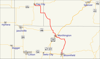
State Road 57 (SR 57) in the U.S. state of Indiana is a north–south, largely two-lane road in the southwestern portion of the state.

Indiana State Road 61 highway in Indiana

State Road 61 is a 64-mile (103 km) north–south route that runs through portions of three counties in the southwest part of the U.S. State of Indiana.

Indiana State Road 68 highway in Indiana

State Road 68 in the U.S. State of Indiana is a 53-mile (85 km) route in Gibson, Posey, Spencer and Warrick counties.

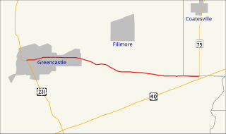
State Road 75, the highest two-digit route in the U.S. state of Indiana consists of two discontinuous north–south segments.

Indiana State Road 161 highway in Indiana

State Road 161 in the U.S. State of Indiana is a rural undivided north–south highway in the southwestern portion of the state.

Indiana State Road 162 highway in Indiana

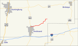
State Road 162 in the U.S. state of Indiana is a 28-mile (45 km) route in Dubois and Spencer counties. Though an even-numbered route, in practice it is a north–south route for most of its length.

Indiana State Road 240 highway in Indiana

State Road 240 in the U.S. state of Indiana is a short connector route in located in eastern Putnam County.

Indiana State Road 241 highway in Indiana

State Road 241 in the U.S. state of Indiana is an 18-mile road that runs entirely within Knox County in the southwest corner of the state.

Indiana State Road 257 highway in Indiana

State Road 257 is a 31-mile route in Daviess and Pike counties in the U.S. State of Indiana.

Indiana State Road 264 highway in Indiana

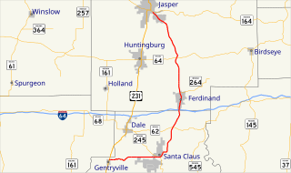
State Road 264 is a short two-lane road in southeast Dubois County in the U.S. state of Indiana.

Indiana State Road 168 highway in Indiana

State Road 168 is a 17-mile-long (27 km) east–west two-lane highway that exists entirely within Gibson County in the far southwestern portion of the state, spanning Barton, Montgomery, and Union townships.

Indiana State Road 157 highway in Indiana

State Road 157 in the U.S. State of Indiana is a north–south route in Clay, Greene and Owen counties that covers a distance of about 26 miles (42 km).

Indiana State Road 159 highway in Indiana

State Road 159 in the U. S. state of Indiana exists in three separate sections.

Indiana State Road 341 highway in Indiana

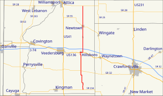
State Road 341 in the U.S. state of Indiana is a north–south state highway in Fountain County in the west-central part of the state.

Kentucky Route 79 (KY 79) is a 104-mile-long (167 km) north–south state highway that traverses five counties in west-central Kentucky. It can be seen as an extension of U.S. Route 79 (US 79), as they have the same number; KY 79 begins in the same city that US 79 ends, and both travel on a northeast–southwest diagonal.

South Carolina Highway 165 highway in South Carolina

South Carolina Highway 165 (SC 165) is a 28.4-mile (45.7 km) state highway in the U.S. state of South Carolina. It connects Yonges Island to U.S. Route 17 (US 17) in Ravenel and US 17 Alternate in Summerville.

References

  1. 1 2 Indiana Department of Transportation (July 2016). Reference Post Book (PDF). Indianapolis: Indiana Department of Transportation. Retrieved February 4, 2017.

Route map: Google

KML file (edithelp)
KML is from Wikidata