Related Research Articles

Stormwater, also spelled storm water, is water that originates from precipitation (storm), including heavy rain and meltwater from hail and snow. Stormwater can soak into the soil (infiltrate) and become groundwater, be stored on depressed land surface in ponds and puddles, evaporate back into the atmosphere, or contribute to surface runoff. Most runoff is conveyed directly as surface water to nearby streams, rivers or other large water bodies without treatment.
A sanitary sewer is an underground pipe or tunnel system for transporting sewage from houses and commercial buildings to a sewage treatment plant or disposal. Sanitary sewers are a type of gravity sewer and are part of an overall system called a "sewage system" or sewerage. Sanitary sewers serving industrial areas may also carry industrial wastewater. In municipalities served by sanitary sewers, separate storm drains may convey surface runoff directly to surface waters. An advantage of sanitary sewer systems is that they avoid combined sewer overflows. Sanitary sewers are typically much smaller in diameter than combined sewers which also transport urban runoff. Backups of raw sewage can occur if excessive stormwater inflow or groundwater infiltration occurs due to leaking joints, defective pipes etc. in aging infrastructure.

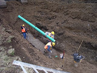
A storm drain, storm sewer, surface water drain/sewer, or stormwater drain is infrastructure designed to drain excess rain and ground water from impervious surfaces such as paved streets, car parks, parking lots, footpaths, sidewalks, and roofs. Storm drains vary in design from small residential dry wells to large municipal systems.

Permeable paving surfaces are made of either a porous material that enables stormwater to flow through it or nonporous blocks spaced so that water can flow between the gaps. Permeable paving can also include a variety of surfacing techniques for roads, parking lots, and pedestrian walkways. Permeable pavement surfaces may be composed of; pervious concrete, porous asphalt, paving stones, or interlocking pavers. Unlike traditional impervious paving materials such as concrete and asphalt, permeable paving systems allow stormwater to percolate and infiltrate through the pavement and into the aggregate layers and/or soil below. In addition to reducing surface runoff, permeable paving systems can trap suspended solids, thereby filtering pollutants from stormwater.

A dry well or drywell is an underground structure that disposes of unwanted water, most commonly surface runoff and stormwater and in some cases greywater. It is a gravity-fed, vertical underground system that captures surface water from impervious surfaces, then stores and gradually infiltrates the water into the groundwater aquifer. Such structures are often called a soakaway in the United Kingdom or a soakwell or soak pit in Australia.

A French drain or weeping tile is a trench filled with gravel or rock, or both, containing a perforated pipe that redirects surface water and groundwater away from an area.
The United States Environmental Protection Agency (EPA) Storm Water Management Model (SWMM) is a dynamic rainfall–runoff–subsurface runoff simulation model used for single-event to long-term (continuous) simulation of the surface/subsurface hydrology quantity and quality from primarily urban/suburban areas. It can simulate the Rainfall- runoff, runoff, evaporation, infiltration and groundwater connection for roots, streets, grassed areas, rain gardens and ditches and pipes, for example. The hydrology component of SWMM operates on a collection of subcatchment areas divided into impervious and pervious areas with and without depression storage to predict runoff and pollutant loads from precipitation, evaporation and infiltration losses from each of the subcatchment. Besides, low impact development (LID) and best management practice areas on the subcatchment can be modeled to reduce the impervious and pervious runoff. The routing or hydraulics section of SWMM transports this water and possible associated water quality constituents through a system of closed pipes, open channels, storage/treatment devices, ponds, storages, pumps, orifices, weirs, outlets, outfalls and other regulators.

Rain gardens, also called bioretention facilities, are one of a variety of practices designed to increase rain runoff reabsorption by the soil. They can also be used to treat polluted stormwater runoff. Rain gardens are designed landscape sites that reduce the flow rate, total quantity, and pollutant load of runoff from impervious urban areas like roofs, driveways, walkways, parking lots, and compacted lawn areas. Rain gardens rely on plants and natural or engineered soil medium to retain stormwater and increase the lag time of infiltration, while remediating and filtering pollutants carried by urban runoff. Rain gardens provide a method to reuse and optimize any rain that falls, reducing or avoiding the need for additional irrigation. A benefit of planting rain gardens is the consequential decrease in ambient air and water temperature, a mitigation that is especially effective in urban areas containing an abundance of impervious surfaces that absorb heat in a phenomenon known as the heat-island effect.

First flush is the initial surface runoff of a rainstorm. During this phase, water pollution entering storm drains in areas with high proportions of impervious surfaces is typically more concentrated compared to the remainder of the storm. Consequently, these high concentrations of urban runoff result in high levels of pollutants discharged from storm sewers to surface waters.

Surface runoff is the flow of water occurring on the ground surface when excess rainwater, stormwater, meltwater, or other sources, can no longer sufficiently rapidly infiltrate in the soil. This can occur when the soil is saturated by water to its full capacity, and the rain arrives more quickly than the soil can absorb it. Surface runoff often occurs because impervious areas do not allow water to soak into the ground. Furthermore, runoff can occur either through natural or man-made processes. Surface runoff is a major component of the water cycle. It is the primary agent of soil erosion by water. The land area producing runoff that drains to a common point is called a drainage basin.
Streamflow, or channel runoff, is the flow of water in streams, rivers, and other channels, and is a major element of the water cycle. It is one component of the runoff of water from the land to waterbodies, the other component being surface runoff. Water flowing in channels comes from surface runoff from adjacent hillslopes, from groundwater flow out of the ground, and from water discharged from pipes. The discharge of water flowing in a channel is measured using stream gauges or can be estimated by the Manning equation. The record of flow over time is called a hydrograph. Flooding occurs when the volume of water exceeds the capacity of the channel.

Sustainable drainage systems are a collection of water management practices that aim to align modern drainage systems with natural water processes and are part of a larger green infrastructure strategy. SuDS efforts make urban drainage systems more compatible with components of the natural water cycle such as storm surge overflows, soil percolation, and bio-filtration. These efforts hope to mitigate the effect human development has had or may have on the natural water cycle, particularly surface runoff and water pollution trends.

Groundwater recharge or deep drainage or deep percolation is a hydrologic process, where water moves downward from surface water to groundwater. Recharge is the primary method through which water enters an aquifer. This process usually occurs in the vadose zone below plant roots and, is often expressed as a flux to the water table surface. Groundwater recharge also encompasses water moving away from the water table farther into the saturated zone. Recharge occurs both naturally and through anthropogenic processes, where rainwater and or reclaimed water is routed to the subsurface.
Landslide mitigation refers to several man-made activities on slopes with the goal of lessening the effect of landslides. Landslides can be triggered by many, sometimes concomitant causes. In addition to shallow erosion or reduction of shear strength caused by seasonal rainfall, landslides may be triggered by anthropic activities, such as adding excessive weight above the slope, digging at mid-slope or at the foot of the slope. Often, individual phenomena join together to generate instability over time, which often does not allow a reconstruction of the evolution of a particular landslide. Therefore, landslide hazard mitigation measures are not generally classified according to the phenomenon that might cause a landslide. Instead, they are classified by the sort of slope stabilization method used:

A well is an excavation or structure created in the ground by digging, driving, or drilling to access liquid resources, usually water. The oldest and most common kind of well is a water well, to access groundwater in underground aquifers. The well water is drawn up by a pump, or using containers, such as buckets or large water bags that are raised mechanically or by hand. Water can also be injected back into the aquifer through the well. Wells were first constructed at least eight thousand years ago and historically vary in construction from a simple scoop in the sediment of a dry watercourse to the qanats of Iran, and the stepwells and sakiehs of India. Placing a lining in the well shaft helps create stability, and linings of wood or wickerwork date back at least as far as the Iron Age.
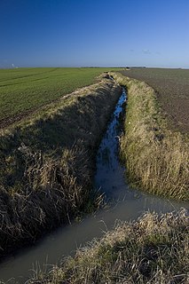
The purpose of a land drain is to allow water in wet or swampy ground to rapidly drain away or to relieve hydrostatic pressure. They are subterranean linear structures which are laid to a fall which should be as steep as practicable. They are used in agriculture and in building construction sites. Modern land drains take the form of a perforated or discontinuous pipe. Typically, the land drains conduct the surplus water to an open ditch or natural water source.
Infiltration/Inflow (I/I) causes dilution in sanitary sewers. Dilution of sewage decreases the efficiency of treatment, and may cause sewage volumes to exceed design capacity. Although inflow is technically different from infiltration, it may be difficult to determine which is causing dilution problems in inaccessible sewers. The United States Environmental Protection Agency defines the term infiltration/inflow as combined contributions from both.
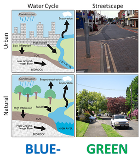
Water-sensitive urban design (WSUD) is a land planning and engineering design approach which integrates the urban water cycle, including stormwater, groundwater, and wastewater management and water supply, into urban design to minimise environmental degradation and improve aesthetic and recreational appeal. WSUD is a term used in the Middle East and Australia and is similar to low-impact development (LID), a term used in the United States; and Sustainable Drainage System (SuDS), a term used in the United Kingdom.

A tree box filter is a best management practice (BMP) or stormwater treatment system widely implemented along sidewalks, street curbs, and car parks. They are used to control the volume and amount of urban runoff pollutants entering into local waters, by providing areas where water can collect and naturally infiltrate or seep into the ground. Such systems usually consist of a tree planted in a soil media, contained in a small, square, concrete box. Tree box filters are popular bioretention and infiltration practices, as they collect, retain, and filter runoff as it passes through vegetation and microorganisms in the soil. The water is then either consumed by the tree or transferred into the storm drain system.
A gravity sewer is a conduit utilizing the energy resulting from a difference in elevation to remove unwanted water. The term sewer implies removal of sewage or surface runoff rather than water intended for use; and the term gravity excludes water movement induced through force mains or vacuum sewers. Most sewers are gravity sewers; because gravity offers reliable water movement with no energy costs wherever grades are favorable. Gravity sewers may drain to sumps where pumping is required to either force sewage to a distant location or lift sewage to a higher elevation for entry into another gravity sewer, and lift stations are often required to lift sewage into sewage treatment plants. Gravity sewers can be either sanitary sewers, combined sewers, storm sewers or effluent sewers.
References
- ↑ United States Department of the Interior Bureau of Reclamation (1977). Ground Water Manual. United States Government Printing Office. pp. 341–349.
- ↑ http://www.wateraid.org/documents/plugin_documents/ifg_guidelines.pdf [ bare URL PDF ]