
Shackleton Glacier is a major Antarctic glacier, over 60 nautical miles long and from 5 to 10 nautical miles wide, descending from the Antarctic Plateau from the vicinity of Roberts Massif and flowing north through the Queen Maud Mountains to enter the Ross Ice Shelf between Mount Speed and Waldron Spurs. Discovered by the United States Antarctic Service (USAS) (1939–41) and named by the Advisory Committee on Antarctic Names (US-ACAN) for Sir Ernest Shackleton, British Antarctic explorer.
Caconda is a town and a municipality in the province of Huíla, Angola. The municipality had a population of 167,820 in 2014.

Arani is a province in Cochabamba Department, Bolivia. Its capital is Arani, situated about 53 km from Cochabamba. Arani is known for its bread and its artisan wickerwork.

Tapacarí is a province in the Cochabamba Department, Bolivia. Its capital is Tapacarí. The province is located at a turnoff from the major highway that links Cochabamba and Oruro. It has traditionally been amongst the poorest in the department. Tapacarí Province and neighboring Arque Province are the two poorest of the 16 provinces that make up the department of Cochabamba.
Sud Yungas or Sur Yungas is a province in the Bolivian department of La Paz. It was created during the presidency of José Manuel Pando on January 12, 1900. The capital of the province is Chulumani.

Eliodoro Camacho is a province in the La Paz Department in Bolivia situated at Lake Titicaca. Its seat is Puerto Acosta.
Hobbs Coast is that portion of the coast of Marie Byrd Land, Antarctica extending from Cape Burks to a point on the coast opposite eastern Dean Island, at 74°42′S127°05′W, or between the Ruppert Coast in the west and the Bakutis Coast in the east. It stretches from 136°50′W to 127°35′. The coast was discovered by the US Antarctic Service (1939–1941) and named for Professor William H. Hobbs of the University of Michigan, a glaciologist specializing in polar geography and history. The United States Geological Survey completely mapped the coast from ground surveys and U.S. Navy air photos, 1959–1965.

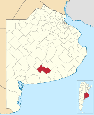
Olavarría Partido is a partido in the central region of Buenos Aires Province in Argentina.
Adolfo Gonzales Chaves is a partido of Buenos Aires Province in Argentina, it is located at coordinates 38°02′S60°05′W.

Almansa is a Spanish Denominación de Origen Protegida (DOP), known for its red wines, located in the southeast of the province of Albacete, in the transition zone between the high central plateau and the Mediterranean Sea. The vineyards are mostly around the towns of Almansa, Alpera, Bonete, Corral-Rubio, Higueruela, Hoya-Gonzalo, Pétrola and El Villar de Chinchilla.
Sidibela is a commune in the Cercle of Bafoulabé in the Kayes Region of south-western Mali. The main village (chef-lieu) is Tigana. In the 2009 census the commune had a population of 5966.

La Hiruela is a municipality of the Community of Madrid, Spain. With a population of 75 inhabitants, in 2017 it was the third least populated municipality in the province.
La Punilla is a village and municipality in San Luis Province in central Argentina.
La Candelaria (Catamarca) is a village and municipality in Catamarca Province in northwestern Argentina.
Archer Glacier is a glacier flowing northwest into the head of Bolson Cove, Flandres Bay, on the west coast of Graham Land.

Gerry Glacier is a glacier on Edward VII Peninsula, Antarctica, flowing north between Reeves Peninsula and the Howard Heights to the head of Sulzberger Bay. Features in this area were photographed from the air and mapped by the Byrd Antarctic Expeditions, 1928–30 and 1933–35. This glacier was mapped by the United States Geological Survey from surveys and U.S. Navy air photos, 1959–65, and was named by the Advisory Committee on Antarctic Names for U.S. Senator Peter G. Gerry of Rhode Island, a long-time friend of the Byrd family and a contributor to the 1933–35 expedition.

Hull Glacier is a glacier, about 35 nautical miles (65 km) long, flowing northwest between Mount Giles and Mount Gray into Hull Bay, in Marie Byrd Land, Antarctica. It was discovered by the United States Antarctic Service (1939–41) and named for U.S. Secretary of State Cordell Hull.
Roberts Massif is a remarkable snow-free massif at the head of Shackleton Glacier. It rises to over 2,700 metres (8,900 ft) and is about 60 square nautical miles in area.
Bni Gmil is a small town and rural commune in Al Hoceïma Province of the Taza-Al Hoceima-Taounate region of Morocco. At the time of the 2014 census, the commune had a total population of 9513 people.