Transportation in Malawi is poorly developed. The country of almost 14 million has 39 airports, 6 with paved runways and 33 with unpaved runways. It has 495 miles (797 km) of railways, all narrow-gauge and about 45 percent of its roads are paved. Though it is landlocked, Malawi also has 435 miles (700 km) of waterways on Lake Malawi and along the Shire River.
This article ia about the transport in Zambia.

The Tokyo Metro Chiyoda Line is a rapid transit line owned and operated by Tokyo Metro in Tokyo, Japan. On average, the line carries 1,447,730 passengers daily (2017), the second highest of the Tokyo Metro network, behind the Tozai Line (1,642,378).

Parrs Wood is an area of East Didsbury, in the southern part of the city of Manchester, England.

Songea is the capital of Ruvuma Region in southwestern Tanzania. It is located along the A19 road. The city has a population of approximately 203,309, and it is the seat of the Roman Catholic Archdiocese of Songea. Between 1905 and 1907, the city was a centre of African resistance during the Maji Maji Rebellion in German East Africa. The city is poised to experience significant economic growth in the near future as the Mtwara Corridor opens up in a few years.
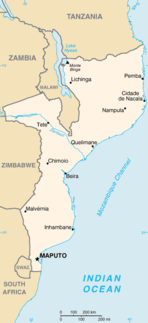
Nacala, also known as Cidade de Nacala or Nacala-Porto is a city on the northern coast of Mozambique. Located in the southwestern indentation of inner Fernao Veloso Bay, it is the deepest natural port on the east coast of Africa. Nacala serves as the terminal for the Northern Development Corridor, a rail link to the landlocked Malawi. South of Nacala is Mozambique Island, at one time the capital of Mozambique and now a World Heritage site.

The Kolkata Suburban Railway is a suburban rail system serving the suburbs surrounding the city of Kolkata. Railways such as this are important and heavily used infrastructure in India. It is the largest suburban railway network in India by track length and number of stations. It has 393 stations and a track length of 1,332 km. The suburban railway operates 1497 EMU services carrying 3.5 million people daily. It runs from 4 a.m to 2 a.m in the night.

Caia is a town on the south bank of the Zambezi River in Sofala Province, Mozambique. It is a relatively small town with few modern facilities besides a petrol station managed by a Portuguese couple and the neighbouring bank. Caia and surrounding communities have been experiencing an escalating HIV/AIDS epidemic, drawing national and foreign aid to the area, including a Canadian foundation called the Caia Connection based in Vila de Sena, 57.6 Kilometres north of Caia.

Marromeu is a town in central Mozambique on the south side of the Zambezi River.
Vila de Sena or more commonly Sena is a town in Mozambique where there is a fundamental bridge over the Zambezi River. This bridge, the Dona Ana Bridge was originally a single track railway bridge, temporarily converted to road operation during the civil war.
Inhaminga is an administrative post of Cheringoma District of Sofala Province in Mozambique. It limits to the north and northwest by the district of Caia, on the west by districts of Gorongosa and Maringue, south to Mwanza district, southeast Indian Ocean to the east and northeast and to the district of Marromeu.
The Western Railway Elevated Corridor, also known as the Oval Maidan-Virar elevated corridor, was a proposed rapid transit corridor that would have run along the same alignment as the Western Line of the Mumbai Suburban Railway, and link Oval Maidan with Virar.

The Shijiazhuang railway station is the main railway station of Shijiazhuang, the capital of Hebei Province of the People's Republic of China. Over the city's history, the name has been applied to several different facilities located in the main Beijing-Guangzhou railway corridor. The current Shijiazhuang railway station was opened in December 2012; it is one of the very few stations in this railway corridor that serve both the ("conventional") Beijing–Guangzhou Railway and the new Beijing–Guangzhou High-Speed Railway.

Nagpur Metro is a rapid transit system for the city of Nagpur, India. It is estimated to cost ₹8,260 crore (US$1.2 billion). In February 2014, the Government of Maharashtra gave approval for the Metro Project, while Government of India's Ministry of Urban Development had given "In Principle" approval for the Project. On 20 August 2014, Union Cabinet gave approval for the development of project, and Prime Minister Narendra Modi laid foundation stone on 21 August on his visit to the city. Construction on the project began on 31 May 2015, with trial run beginning on 30 September 2017.

The Mtwara Development Project is a major infrastructure development project involving southern Tanzania, northern Mozambique, eastern Malawi and Eastern Zambia. The goal of this project is to provide road, rail and waterway access from the surrounding region to the Port of Mtwara. The region and the corridor has been neglected by the respective governments for over 40 years and the recent discovery of oil, gas and various minerals has kick started the development of the project. A road and rail link is to be built from the port of Mtwara to Mbamba Bay on Lake Nyasa to link Malawi to the corridor and further road links into Mozambique will facilitate access to northern Mozambique.

The Cheringoma Plateau is a low plateau in Sofala Province of Mozambique. It lies mostly within Cheringoma, Muanza, and Marromeu districts.