Shikoku is one of the four main islands of Japan. Shikoku is the smallest and least populous of the main islands, located south of Honshu and east of Kyushu. Shikoku's ancient names include Iyo-no-futana-shima (伊予之二名島), Iyo-shima (伊予島), and Futana-shima (二名島), and its current name refers to the four former provinces that made up the island: Awa, Tosa, Sanuki, and Iyo.

The Akashi Kaikyō Bridge is a suspension bridge, which links the city of Kobe on the Japanese mainland of Honshu to Iwaya on Awaji Island. It crosses the busy Akashi Strait as part of the Honshu–Shikoku Highway. It was completed in 1998, and has the longest central span of any suspension bridge in the world, at 1,991 metres. It is one of the key links of the Honshū–Shikoku Bridge Project, which created three routes across the Inland Sea.

Hiroshima Prefecture is a prefecture of Japan located in the Chūgoku region on Honshu island. The capital is the city of Hiroshima. It has a population of around 2.8 million.
The Seto Inland Sea, also known as Setouchi or often shortened to Inland Sea, is the body of water separating Honshū, Shikoku, and Kyūshū, three of the four main islands of Japan. The region that includes the Seto Inland Sea and the coastal areas of Honshū, Shikoku, and Kyūshū is known as the Setouchi Region. It serves as a waterway, connecting the Pacific Ocean to the Sea of Japan. It connects to Osaka Bay and provides a sea transport link to industrial centers in the Kansai region, including Osaka and Kobe. Before the construction of the San'yō Main Line, it was the main transportation link between Kansai and Kyūshū.

The Honshu-Shikoku Bridge Project is a system of bridges connecting the islands of Honshu and Shikoku across the Inland Sea of Japan, which were previously only connected by ferry. It consists of three major connections. All bridges are now controlled by the Honshu-Shikoku Bridge Expressway Company and the Japan Expressway Holding and Debt Repayment Agency (日本高速道路保有・債務返済機構). The system consists of three expressways and their respective bridge systems.

The Great Seto Bridge is a series of double deck bridges connecting Okayama and Kagawa prefectures in Japan across a series of five small islands in the Seto Inland Sea. Built over the period 1978–88, it is one of the three routes of the Honshū–Shikoku Bridge Project connecting Honshū and Shikoku islands, and the only one with railroad connections included. At 13.1 kilometers (8.1 mi), it ranks as the world's longest two-tiered bridge system.

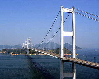
The Tatara Bridge is a cable-stayed bridge that is part of the Nishiseto Expressway, commonly known as the Shimanami Kaidō しまなみ海道. The bridge has a center span of 890 metres (2,920 ft). As of 2010 it has the fourth longest main span of any cable-stayed bridge after the Sutong Bridge. The expressway is a series of roads and bridges that is one of the three routes of the Honshū-Shikoku Bridge Project connecting the islands of Honshū and Shikoku across the Seto Inland Sea in Japan. The Kurushima-Kaikyō Bridge is on the same route.
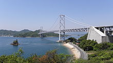
The Kurushima-Kaikyō Bridge, which connects the island of Ōshima to the main part of Shikoku, is the world's longest suspension bridge structure and was completed in 1999. The bridge is part of the Shimanami Kaidō, an expressway that spans a series of islands and connects Hiroshima Prefecture in Honshū to Ehime Prefecture in Shikoku. The bridge and the expressway were both conceived by the Honshū-Shikoku Bridge Project.

The Ōnaruto Bridge is a suspension bridge on the Kobe-Awaji-Naruto Expressway connecting Minamiawaji, Hyogo on Awaji Island with Naruto, Tokushima on Ōge Island, Japan. Completed in 1985, it has a main span of 876 metres (2,874 ft). Although it is one of the largest bridges in the world, it is dwarfed by the Akashi-Kaikyo Bridge, which is on the same route. In 2004, 6.8 million cars and trucks crossed this bridge, translating into a daily average of about 18,600.
The Hakata-Ōshima Bridge is a Japanese suspension bridge, part of the 59 kilometer Nishiseto Expressway connecting the islands of Honshū and Shikoku. Completed in 1988, it has a main span of 560 meters and connects Hakatajima with Ōshima. The expressway connects seven small islands and also includes several other long span bridges including the Tatara Bridge, the Innoshima Bridge, and the Kurushima-Kaikyō Bridge.
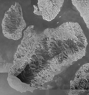
Ōshima (大島) is an island in the Seto Inland Sea that lies between the larger islands of Honshū and Shikoku in Japan. It is part of Ehime Prefecture and is governed by the city of Imabari.
The Honshu-Shikoku Bridge Expressway Company Limited, abbreviated as JB本四高速 in Japanese or HSBE in English, operates the Kobe-Awaji-Naruto, Nishiseto, and Seto-Chūō expressways and their respective bridges between the islands of Honshu and Shikoku, Japan. It is headquartered in Chūō-ku, Kōbe, Hyōgo Prefecture.

Mukaishima Island is the northernmost island in Geiyo Islands chain accommodating Nishiseto Expressway connecting Honshu and Shikoku islands. Its coasts are washed by Seto Inland Sea. The island's highest peak is Takamiyama (高見山) 283.2 m (929 ft) high.

Ōmishima Island is the westernmost and largest island in Geiyo Islands chain accommodating Nishiseto Expressway connecting Honshu and Shikoku islands. Its coasts are washed by Seto Inland Sea. The island's highest peak is Washigatozan (鷲ヶ頭山) 437 m (1,434 ft) high.
The Geiyo Islands are a group of islands in the Seto Inland Sea of Hiroshima Prefecture. They are roughly defined as laying in the western part of Seto Inland Sea, from Hiuchi-nada to Aki-nada. Largest islands in archipelago are connected by Nishiseto Expressway bridge system connecting Honshu and Shikoku islands. Alternative and narrower definition is the "all islands laying between ancient Iyo Province and Bizen Province". The islands of in Hiroshima Bay, most notably Etajima and Kurahashi-jima, are therefore excluded from the Geiyo Islands archipelago narrower definition.
Ikuchi-jima is an island in the Seto Inland Sea, belonging to Hiroshima Prefecture in Japan. Ikuchi-jima is administered as part of Onomichi city. The bridges connecting Ikuchi-jima to the mainland Honshu island via Innoshima and to Shikoku via Ōmishima island. The island's highest peak is Mount Kanno 472.3 m (1,550 ft).

The Seto-Chūō Expressway is a tolled expressway that connects Okayama and Kagawa prefectures in Japan across a series of five small islands in the Seto Inland Sea. Built between 1978 and 1988, it is one of the three routes of the Honshu-Shikoku Bridge Expressway Company connecting Honshū and Shikoku islands. The route is signed E30 under Ministry of Land, Infrastructure, Transport and Tourism's "2016 Proposal for Realization of Expressway Numbering."
The Kobe-Awaji-Naruto Expressway is a tolled expressway that connects Hyōgo and Tokushima prefectures in Japan by crossings of the Akashi Strait and Naruto Strait. Built between 1970 and 1998, it is one of the three routes of the Honshu-Shikoku Bridge Expressway Company connecting Honshū and Shikoku islands. The route is signed E28 under Ministry of Land, Infrastructure, Transport and Tourism's "2016 Proposal for Realization of Expressway Numbering."