
Yukon is in the northwestern corner of Canada and is bordered by Alaska and the Northwest Territories. The sparsely populated territory abounds with natural scenery, snowmelt lakes and perennial white-capped mountains, including many of Canada's highest mountains. The territory's climate is Arctic in territory north of Old Crow, subarctic in the region, between Whitehorse and Old Crow, and humid continental climate south of Whitehorse and in areas close to the British Columbia border. Most of the territory is boreal forest with tundra being the main vegetation zone only in the extreme north and at high elevations.

Pechora-Ilych Nature Reserve is a Russian 'zapovednik' in the Komi Republic, Russia. It currently occupies 7,213 square kilometers and forms the core of the World Heritage Site Virgin Komi Forests.

The New England-Acadian forests are a temperate broadleaf and mixed forest ecoregion in North America that includes a variety of habitats on the hills, mountains and plateaus of New England and New York State in the Northeastern United States, and Quebec and the Maritime Provinces of Eastern Canada.

The Alberta–British Columbia foothills forests are a temperate coniferous forests ecoregion of Western Canada, as defined by the World Wildlife Fund (WWF) categorization system. This ecoregion borders Canada's taiga and contains a mix of subarctic forest and temperate forest species as a result. This makes the region an ecotone region, or a region that acts as a buffer between two other biomes.

The Eastern Canadian Shield taiga is an ecoregion of Canada as defined by the World Wildlife Fund (WWF) categorization system.

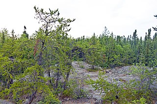
The Yukon Interior dry forests is a taiga ecoregion of Canada.

The Muskwa-Slave Lake forests ecoregion covers Canadian taiga in northwestern Alberta, northeastern British Columbia and a large portion of the southwestern Northwest Territories around the Mackenzie River valley and the Great Slave Lake.

The North Central Rockies forests is a temperate coniferous forest ecoregion of Canada and the United States. This region overlaps in large part with the North American inland temperate rainforest and gets more rain on average than the South Central Rockies forests and is notable for containing the only inland populations of many species from the Pacific coast.

The interior Alaska–Yukon lowland taiga is an ecoregion in the taiga and boreal forests biome, of far northern North America.

The Midwestern Canadian Shield forests ecoregion, in the Taiga and Boreal forests Biome, are of northern Canada.

The Northeast Siberian taiga ecoregion is an area of "sparse taiga forest" between the Lena River and the Kolyma River in northeastern Siberia, Russia. The ecoregion's internal borders form a patchwork of territory constituting the southern part of the East Siberian Lowland, as well as lowlands around the East Siberian Mountains, including the ridges and peaks of the Verkhoyansk Range and the Chersky Range. On the southern border of the ecoregion is the north coast of the Sea of Okhotsk, giving the region maritime boreal forests as well as the continental forests situated inland. The ecoregion is one of the largest tracts of virgin boreal forest in the world, due to the very sparse population and difficult access. It is mostly in the Sakha Republic.
Northern Canadian Shield taiga is a taiga ecoregion located in northern Canada, stretching from Great Bear Lake in the Northwest Territories to Hudson Bay in eastern Nunavut. The region supports conifer forests to its northern edge, where the territory grades into tundra. The open forest in this transition zone is characterized by widely scattered, stunted stands of black spruce and tamarack, with some white spruce. The ecoregion lies over the northwestern extent of the Canadian Shield.

Northern transitional alpine forests is a temperate coniferous forest ecoregion in the northwestern interior of British Columbia, as defined by the World Wildlife Fund (WWF) categorization system.

Pacific Coastal Mountain icefields and tundra is a tundra ecoregion in Alaska, British Columbia, and Yukon, as defined by the World Wildlife Fund (WWF) categorization system.

Northern Cordillera forests is a taiga ecoregion that extends across the northern interior of British Columbia, southern Yukon, and a small area of the Northwest Territories as defined by the World Wildlife Fund (WWF) categorization system.
The Northwest Territories taiga ecoregion (WWF:NA0614) is located in the Northwest Territories and Yukon provinces of Canada. It covers forest and tundra along the Mackenzie River Valley and the surrounding highlands in the southern portion of the valley.

The Canadian Low Arctic Tundra ecoregion covers a rolling landscape of shrubby tundra vegetation along the northern edge of the mainland Canada along the border of the Northwest Territories and Nunavut, and a small portion in Quebec on the northeast coast of Hudson Bay. The region is important for large herds of caribou and other large mammals, and for large nesting colonies of birds such as snow geese. The region is mostly intact, with 95% remaining intact.

The Ogilvie–MacKenzie alpine tundra ecoregion covers the mountainous middle of the Yukon Territory in Canada, with extensions into the Northwest Territories. The vegetation is alpine and subalpine open forest of stunted spruce, fir and pine. The area is rugged but sections appear to have been unglaciated in the late Pleistocene and there are therefore relic species in the region. The area is remote and supports large, sustainable predator-prey systems.
Tokinsko-Stanovoy National Park is located at the mountainous headwaters of the Zeya River, in the Stanovoy Highlands of the Russian Far East. It was created in 2019 to protect important natural features - particularly the Siberian snow sheep, and also the cultural heritage of the reindeer-herding indigenous Evenki people. The park is located in the Zeysky District of Amur Oblast, at the meeting point of the borders of Amur Oblast, the Sakha Republic, and Khabarovsk Krai.

Zigalga National Park is located on the high Zigalga Ridge of the Southern Ural Mountains in Russia, on the transition between Europe and Siberia. Much of the territory is untouched by human activity and so supports Ice Age relict floral communities through all altitude zones - pine and birch forest, dark coniferous taiga, alpine meadows and mountain tundra. The park was officially created in 2019. The park is located in the Katav-Ivanovsky District of Chelyabinsk Oblast.

