
Geotechnical engineering, also known as geotechnics, is the branch of civil engineering concerned with the engineering behavior of earth materials. It uses the principles of soil mechanics and rock mechanics to solve its engineering problems. It also relies on knowledge of geology, hydrology, geophysics, and other related sciences.

The University of Oslo is a public research university located in Oslo, Norway. It is the oldest university in Norway. Originally named the Royal Frederick University, the university was established in 1811 as the de facto Norwegian continuation of Denmark-Norway's common university, the University of Copenhagen, with which it shares many traditions. It was named for King Frederick VI of Denmark and Norway, and received its current name in 1939. The university was commonly nicknamed "The Royal Frederick's" before the name change, and informally also referred to simply as Universitetet.

The Norwegian Institute of Technology was a science institute in Trondheim, Norway. It was established in 1910, and existed as an independent technical university for 58 years, after which it was merged into the University of Trondheim as an independent college.

A geologic hazard or geohazard is an adverse geologic condition capable of causing widespread damage or loss of property and life. These hazards are geological and environmental conditions and involve long-term or short-term geological processes. Geohazards can be relatively small features, but they can also attain huge dimensions and affect local and regional socio-economics to a large extent.
Norwegian Geotechnical Institute is an independent international centre for research and consultancy in engineering-related geosciences, integrating geotechnical, geological and geophysical expertise.
The Indian Institute of Remote Sensing is an institute for research, higher education and training in the field of remote sensing, geoinformatics and GPS technology for natural resources, environmental and disaster management under the Indian Department of Space, which was established in the year 1966. It is located in the city of Dehradun, Uttarakhand.

Lake Sinoe is a lagoon in Northern Dobruja, Romania, close to the Black Sea. Its name derives from Slavic. The ruins of the ancient Greek colony of Histria are located on the lake shore.
Ralph Brazelton Peck was a civil engineer specializing in soil mechanics. He was awarded the National Medal of Science in 1976 "for his development of the science and art of subsurface engineering, combining the contributions of the sciences of geology and soil mechanics with the practical art of foundation design"?

The International Association for Engineering Geology and the Environment, formerly International Association for Engineering Geology, also known as IAEG, is an international scientific society which was founded in 1964. It is affiliated with the International Union of Geological Sciences (IUGS) and has 3,798 members and 59 national groups all over the world.
The Ritland crater is an impact crater at Ritland farm in Hjelmeland municipality in eastern Rogaland county, Norway. The crater is about 15 kilometres (9.3 mi) east of the village of Hjelmelandsvågen and about 8 kilometres (5.0 mi) south of the Jøsenfjorden. The crater is about 2 kilometres (1.2 mi) in diameter, and was created when a meteorite with an estimated diameter of 100 metres (330 ft) struck here about 500–600 million years ago. The crater was later buried by sediments, of which it has been partly recovered.
Thomas Denis O’Rourke is an American educator, engineer and serves as the Thomas R. Biggs Professor of civil & environmental engineering at the Cornell University College of Engineering. O’Rourke took his Bachelor of Science in civil engineering at Cornell's engineering college in 1970 and his doctorate at the University of Illinois Urbana-Champaign in 1975.

Suction caissons are a form of fixed platform anchor in the form of an open bottomed tube embedded in the sediment and sealed at the top while in use so that lifting forces generate a pressure differential that holds the caisson down. They have a number of advantages over conventional offshore foundations, mainly being quicker to install than deep foundation piles and being easier to remove during decommissioning. Suction caissons are now used extensively worldwide for anchoring large offshore installations, like oil platforms, offshore drillings and accommodation platforms to the seafloor at great depths. In recent years, suction caissons have also seen usage for offshore wind turbines in shallower waters.
Oslo and Akershus University College was the largest state university college in Norway from its establishment in 2011 until 2018, when it was transformed into Oslo Metropolitan University, the youngest of Norway's new universities.
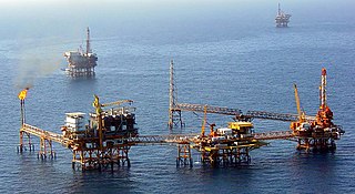
Offshore geotechnical engineering is a sub-field of geotechnical engineering. It is concerned with foundation design, construction, maintenance and decommissioning for human-made structures in the sea. Oil platforms, artificial islands and submarine pipelines are examples of such structures. The seabed has to be able to withstand the weight of these structures and the applied loads. Geohazards must also be taken into account. The need for offshore developments stems from a gradual depletion of hydrocarbon reserves onshore or near the coastlines, as new fields are being developed at greater distances offshore and in deeper water, with a corresponding adaptation of the offshore site investigations. Today, there are more than 7,000 offshore platforms operating at a water depth up to and exceeding 2000 m. A typical field development extends over tens of square kilometers, and may comprise several fixed structures, infield flowlines with an export pipeline either to the shoreline or connected to a regional trunkline.
Suzanne Lacasse is a Canadian civil engineer. She obtained her PhD in 1976.
Total sounding (TS) is a sounding method performed as part of geotechnical investigation. The sounding combines conventional rotary-pressure sounding with bedrock drilling, including rotation, ramming and flushing modes. The result indicates sediment stratification, occasionally soil type and may verify depth to bedrock.
Rotary-pressure sounding is a method of testing soil conditions that might be performed as part of a geotechnical investigation. A series of rods, with a specially designed tip, is forced into the ground under downward pressure. The rotation and speed of insertion are maintained at a constant rate, and the amount of force required to maintain that rate is measured. The results can be interpreted to provide information about sediment stratification, and sometimes also the type of soil and the depth to bedrock.

Geological engineering is a discipline of engineering concerned with the application of geological science and engineering principles to fields, such as civil engineering, mining, environmental engineering, and forestry, among others. The work of geological engineers often directs or supports the work of other engineering disciplines such as assessing the suitability of locations for civil engineering, environmental engineering, mining operations, and oil and gas projects by conducting geological, geoenvironmental, geophysical, and geotechnical studies. They are involved with impact studies for facilities and operations that affect surface and subsurface environments. The engineering design input and other recommendations made by geological engineers on these projects will often have a large impact on construction and operations. Geological engineers plan, design, and implement geotechnical, geological, geophysical, hydrogeological, and environmental data acquisition. This ranges from manual ground-based methods to deep drilling, to geochemical sampling, to advanced geophysical techniques and satellite surveying. Geological engineers are also concerned with the analysis of past and future ground behaviour, mapping at all scales, and ground characterization programs for specific engineering requirements. These analyses lead geological engineers to make recommendations and prepare reports which could have major effects on the foundations of construction, mining, and civil engineering projects. Some examples of projects include rock excavation, building foundation consolidation, pressure grouting, hydraulic channel erosion control, slope and fill stabilization, landslide risk assessment, groundwater monitoring, and assessment and remediation of contamination. In addition, geological engineers are included on design teams that develop solutions to surface hazards, groundwater remediation, underground and surface excavation projects, and resource management. Like mining engineers, geological engineers also conduct resource exploration campaigns, mine evaluation and feasibility assessments, and contribute to the ongoing efficiency, sustainability, and safety of active mining projects
Steven Lawrence Kramer is Professor Emeritus of Geotechnical Engineering at the University of Washington.