
Shoreline is a city in King County, Washington, United States. It is located between the city limits of Seattle and the Snohomish County border, approximately 9 miles (14 km) north of Downtown Seattle. As of the 2020 census, the population of Shoreline was 58,608, making it the 22nd largest city in the state. Based on per capita income, one of the more reliable measures of affluence, Shoreline ranks 91st of 522 areas in the state of Washington to be ranked.

Tukwila is a suburban city in King County, Washington, United States, located immediately to the south of Seattle. The population was 21,798 at the 2020 census.

Edgewood is a city in Pierce County, Washington, United States. The population was 12,327 at the 2020 census. Neighboring towns include Fife to the west, Milton to the northwest, Federal Way to the north, Sumner to the east, and Puyallup to the south.

South Hill is a census-designated place (CDP) in Pierce County, Washington, immediately south of Puyallup. The population was 64,708 at time of the 2020 census, up from 52,431 in 2010. The area primarily consists of suburban housing and shopping with several retail shopping centers, residential neighborhoods, and apartment/condo complexes throughout. Because South Hill is unincorporated, its addresses are part of the Puyallup "postal city" or ZCTA.

State Route 99 (SR 99), also known as the Pacific Highway, is a state highway in the Seattle metropolitan area, part of the U.S. state of Washington. It runs 49 miles (79 km) from Fife to Everett, passing through the cities of Federal Way, SeaTac, Seattle, Shoreline, and Lynnwood. The route primarily follows arterial streets, including Aurora Avenue, and has several freeway segments, including the tolled SR 99 Tunnel in Downtown Seattle. SR 99 was officially named the William P. Stewart Memorial Highway by the state legislature in 2016, after a campaign to replace an unofficial moniker honoring Confederate president Jefferson Davis.

The Ballard Terminal Railroad Company LLC operates two Class III short line terminal railroads in western Washington, United States. Founded in 1997 to operate a three-mile spur through Seattle's Ballard neighborhood, the Ballard Terminal Railroad has expanded to operate two additional lines in the Puget Sound area, including Eastside Freight Railroad from Snohomish to Woodinville, Washington, and Meeker Southern Railroad, a 5 mi (8.0 km) segment from East Puyallup ("Meeker") to McMillin, Washington. Eastside Freight Railroad has ceased operation as of mid 2020.

State Route 599 (SR 599) is a state highway and freeway in King County, Washington, United States. It is located entirely within the city of Tukwila and travels 1.75 miles (2.82 km) northwest along the Duwamish River between junctions with Interstate 5 (I-5) and SR 99. The freeway has one intermediate exit and follows the Central Link light rail line.
State Route 167 (SR 167) is a state highway in the Seattle metropolitan area of Washington state. It is commonly known as the Valley Freeway and serves the Green River Valley from Tacoma to Renton, primarily as a four-lane freeway. The 28-mile (45 km) highway begins in Tacoma at an interchange with Interstate 5 (I-5) and travels southeast to Puyallup as an undivided road. It then turns northeast onto a freeway and passes through interchanges with SR 512 in Puyallup and SR 410 in Sumner, continuing north through Auburn and Kent. After an interchange with I-405 in Renton, it terminates at an intersection with SR 900.

The Foothills Trail is a mostly paved non-motorized rail-trail in east Pierce County, Washington, extending uninterrupted for 21 miles (34 km) from Puyallup, Washington through Orting and South Prairie, and terminating in Buckley. The trail is used by cyclists, walkers, joggers, inline skaters, and horse riders. Listed as Foothills Regional Trail, it was designated a National Recreation Trail in 2012.

State Route 161 (SR 161) is a 36.25-mile-long (58.34 km) state highway serving Pierce and King counties in the U.S. state of Washington. The highway begins at SR 7 southwest of Eatonville and travels north as Meridian Avenue to Puyallup, becoming concurrent with SR 512 and SR 167. SR 161 continues northwest as the Enchanted Parkway to end at an intersection with SR 18 in Federal Way, west of Interstate 5 (I-5). The highway serves the communities of Graham and South Hill before reaching Puyallup and the communities of Edgewood, Milton, and Lakeland South before reaching Federal Way.

State Route 96 (SR 96) is a 6.75-mile-long (10.86 km) state highway located within Snohomish County in the U.S. state of Washington. The highway travels east from an interchange with Interstate 5 (I-5) in Paine Field-Lake Stickney through Mill Creek and an intersection with SR 527 to end at SR 9 south of Snohomish. SR 96 was established in 1991 and follows the route of a wagon road constructed by Snohomish County in the late 1880s to connect Snohomish to Seattle. The highway was closed during the Great Coastal Gale of 2007 after a culvert was damaged and its eastern terminus was re-constructed in 2009 to serve increasing volumes of traffic.

Interstate 5 (I-5) is an Interstate Highway on the West Coast of the United States that serves as the region's primary north–south route. It spans 277 miles (446 km) across the state of Washington, from the Oregon state border at Vancouver, through the Puget Sound region, to the Canadian border at Blaine. Within the Seattle metropolitan area, the freeway connects the cities of Tacoma, Seattle, and Everett.
State Route 162 (SR 162) is a 17.37-mile-long (27.95 km) state highway in the U.S. state of Washington, serving rural Pierce County. The highway travels from an interchange with SR 410 in Sumner and travels south along the Puyallup River to Orting and northeast to South Prairie, ending at an intersection with SR 165 near Buckley. SR 162 was established in 1964 as the successor to Secondary State Highway 5E (SSH 5E), codified in 1937. The highway crossed the Puyallup River northwest of Orting on the McMillin Bridge, which opened in 1934 and was replaced with a newer bridge that opened in 2015.

The Interurban Trail is a rail trail in Snohomish County, Washington. It is a hard-surfaced, non-motorized trail located on the Pacific Northwest Traction right-of-way, a route used until 1939 by the Interurban Railroad between Seattle and Bellingham. The trail in Snohomish County runs over 16 miles (26 km).

The Snohomish County Centennial Trail is a 30-mile-long (48 km) rail trail in Snohomish County, Washington, connecting the cities of Snohomish, Lake Stevens, and Arlington to Skagit County along the corridor of Washington State Route 9. The trail, administered by Snohomish County Parks and Recreation, is on the former right-of-way of the Seattle, Lake Shore and Eastern Railway and comprises a 10-foot-wide (3.0 m) non-motorized trail and a 6-foot-wide (1.8 m) equestrian trail. The first segment of the corridor was opened in 1989, the centennial of the statehood of Washington, and the final segment between Arlington and the Skagit County line was opened in 2013.
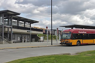
Tukwila station is a train station in Tukwila, Washington, United States. The station was built by Sound Transit to serve its Sounder commuter rail service on the S Line, as well as Amtrak's intercity Cascades line. It includes 390 parking spaces and a bus platform served by King County Metro's RapidRide F Line and other routes.

The Puget Sound Electric Railway was an interurban railway that ran for 38 miles between Tacoma and Seattle, Washington in the first quarter of the 20th century. The railway's reporting mark was "PSE".

The Green River Trail is a 19.6-mile (31.5 km) pedestrian and bicycle trail in King County, Washington, USA. It runs along the banks of the Duwamish and Green Rivers, crossing the river several times on bridges. The trail goes through a variety of landscapes, ranging from industrial to rural.


