
Huancavelica is a department in Peru with an area of 22,131.47 km2 (8,545.01 sq mi) and a population of 347,639. The capital is the city Huancavelica. The region is bordered by the departments of Lima and Ica in the west, Junín in the north, and Ayacucho in the east.

Junín is a region in the central highlands and westernmost Peruvian Amazon. Its capital is Huancayo.
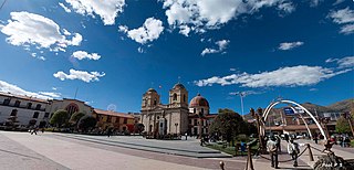
Huancayo is the capital of Junín Region, in the central highlands of Peru.

Huancayo Province is located in Peru. It is one of the 9 provinces composing the Junín Region. It borders to the north with the Concepción Province, the east with the Satipo Province, the south with the Huancavelica Region and the west with the Chupaca Province. The province has an approximate population of 545,615 inhabitants. The capital of the province is the city of Huancayo.

Chupaca Province, located in Central Peru, is one of the nine provinces that compose the Junín Region, bordering to the north with the Concepción Province, to the east with the Huancayo Province, to the south with the Huancavelica Region and to the west with the Lima Region. The province has a population of approximately 57,000 inhabitants, and the capital is Chupaca.
Lake Canllacocha is a lake in Peru located in the Huancavelica Region, Huancavelica Province, Acobambilla District. Canllacocha lies east of the larger Lake Huarmicocha and south of Lake Acchicocha of the Junín Region.
Lake Ancapuachanan is a small lake in the Huaytapallana mountain range in Peru. It is located in the Junín Region, Huancayo Province, El Tambo District. Lake Ancapuachanan is situated north of the lake named Chuspicocha and southwest of Mount Chuspi.

Pacocollo also known as Chancane, is a 5,113-metre-high (16,775 ft) mountain in the Andes of southern Peru. It is located in the Moquegua Region, Mariscal Nieto Province, Carumas District, and in the Tacna Region, Candarave Province, Candarave District. Pacocollo lies west of a lake named Pasto Grande or Ajuachaya and Wila Wilani.
Wachu Intiyuq is a mountain in the Chunta mountain range in the Andes of Peru, about 5,000 metres (16,404 ft) high. It lies in the Huancavelica Region, Huancavelica Province, Huancavelica District, southwest of Antarasu.
Warmi Mach'ay is a mountain in the Andes of Peru, about 4,800 m (15,748 ft) high. It is situated in the Huancavelica Region, Huancavelica Province, Acobambilla District, and in the Junín Region, Huancayo Province, Chongos Alto District. Warmi Mach'ay lies between the lakes named Warmiqucha in the southeast and Quylluqucha in the northwest.
Puka is a 4,993-metre-high (16,381 ft) mountain in the Andes of Peru. It is situated in the Huancavelica Region, Huancavelica Province, Acobambilla District, and in the Junín Region, Huancayo Province, Chongos Alto District. Puka lies southwest of Warmi Mach'ay, between the lakes named Warmiqucha in the southeast and Quylluqucha in the north.
Yawray is a 5,112-metre-high (16,772 ft) mountain in the Andes of Peru. It is located in the Huancavelica Region, Huancavelica Province, Acobambilla District, and in the Junín Region, Huancayo Province, Chongos Alto District. Yawray lies west of Puka and Warmi Mach'ay. Yawray is situated northwest of Aqchiqucha and northeast of Warmiqucha which belong to the largest lakes of Peru.
Puka Rumi is a 5,000-metre-high (16,404 ft) mountain in the northern part of the Chunta mountain range in the Andes of Peru. It is situated in the Huancavelica Region, Huancavelica Province, Acobambilla District, and in the Junín Region, Huancayo Province, Chongos Alto District. Puka Rumi lies southeast of Ñawinqucha.
Waqra Willka is a 5,066-metre-high (16,621 ft) mountain in the Andes of Peru. It is located in the Junín Region, Huancayo Province, Chongos Alto District. Waqra Willka lies east of Wira Challwa. A couple of small lakes named Yuraqqucha, Anqasqucha, Challwaqucha and Antaqucha are situated at the feet of the mountain.
Kapillayuq is a 5,129-metre-high (16,827 ft) mountain in the Andes of Peru. It is located in the Junín Region, Huancayo Province, Chongos Alto District. Kapillayuq lies east of Walsa and west of the lake named Ñawinqucha.
Walsa (Quechua for raft, Hispanicized spelling Balsa is a 4,800-metre-high mountain in the Andes of Peru. It is located in the Junín Region, Huancayo Province, Chongos Alto District. Walsa lies west of Kapillayuq between the lakes Ñawinqucha in the east and Walsaqucha in the northwest.
Kawituyuq is a 4,803-metre-high (15,758 ft) mountain in the Andes of Peru. It is located in the Junín Region, Huancayo Province, Huancayo District. Kawituyuq lies south of the Waytapallana mountain range, southwest of Yana Uqsha.
Putaqa Wayi is a mountain in the Andes of Peru which reaches a height of approximately 4,400 m (14,400 ft). It is located in the Junín Region, Tarma Province, Cajas District.
Putaqa is a mountain in Peru which reaches a height of approximately 4,600 m (15,100 ft). It is located in the Junín Region, Yauli Province, Marcapomacocha District. A small lake named Aququcha lies at its feet.

