Related Research Articles
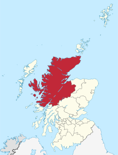
Highland is a council area in the Scottish Highlands and is the largest local government area in the United Kingdom. It was the 7th most populous council area in Scotland at the 2011 census. It shares borders with the council areas of Aberdeenshire, Argyll and Bute, Moray and Perth and Kinross. Their councils, and those of Angus and Stirling, also have areas of the Scottish Highlands within their administrative boundaries.

The River Ness is a river about 6 miles long, which flows from the northern end of Loch Ness in Scotland, through Loch Dochfour, north-east to Inverness, with a total fall in height of about 16 metres before discharging into the Beauly Firth. The river is the origin of the name of Inverness which is from Scottish Gaelic: Inbhir Nis, meaning "Mouth of the Ness".

Dingwall is a town and a royal burgh in the Highland council area of Scotland. It has a population of 5,491. It was an east-coast harbour that now lies inland. Dingwall Castle was once the biggest castle north of Stirling. On the town's present-day outskirts lies Tulloch Castle, parts of which may date back to the 12th-century building. In 1411 the Battle of Dingwall is said to have taken place between the Clan Mackay and the Clan Donald.

The County of Nairn is a historic county, registration county and lieutenancy area of Scotland. The county was used for local administration until the county council, based at the county town of Nairn, was abolished in 1975 under the Local Government (Scotland) Act 1973, the area becoming one of the eight districts of the two-tier Highland region. This arrangement ended in 1996 when the Highland council area was made a unitary authority.

Seil is one of the Slate Islands, located on the east side of the Firth of Lorn, 7 miles southwest of Oban, in Scotland. Seil has been linked to the mainland by bridge since the late 18th century.

Loch Leven is a sea loch located on the west coast of Scotland. It is spelled Loch Lyon in Timothy Pont's map of the area and is pronounced Li' un. The local Gaelic pronunciation is Lee' oon

Braemar is a village in Aberdeenshire, Scotland, around 58 miles (93 km) west of Aberdeen in the Highlands. It is the closest significantly-sized settlement to the upper course of the River Dee sitting at an elevation of 339 metres (1,112 ft).

Baile Chláir or Baile Chláir na Gaillimhe is a Gaeltacht village about 10 km north of Galway city in County Galway, Ireland. Claregalway was founded on the banks of the River Clare, hence the derivation of its name: Baile Chláir na Gaillimhe meaning "town on the Clare, in Galway". Claregalway lies within the Gaeltacht and traditionally most of the locals would have spoken English only as a second language. Until September 2017, the village sat at the junction of the busy N17 and N18 national primary routes with over 27,000 vehicles having formerly passed through the village every day.
Findhorn is a village in Moray, Scotland. It is located on the eastern shore of Findhorn Bay and immediately south of the Moray Firth. Findhorn is 3 miles (5 km) northwest of Kinloss, and about 5 miles (9 km) by road from Forres.
John MacDonald, known as Iain Lom was a Scottish Gaelic poet.

Rock is a small village in east County Tyrone, Northern Ireland located approximately 5 miles south-west of Cookstown. The village and surrounding area is located mainly within the parish of Desertcreat.
Aber and Inver are common elements in place-names of Celtic origin. Both mean "confluence of waters" or "river mouth". Their distribution reflects the geographical influence of the Brittonic and Goidelic language groups, respectively.
Tarves, Aberdeenshire, is a small village, situated in the Formartine area of North East Scotland and lies between Oldmeldrum and Methlick.

Muirtown is an area in the west end of the city of Inverness in the Scottish Highlands. It contains the Muirtown basin and Muirtown Primary School.

The Kessock Ferry used to ply between Inverness and the Black Isle, across the Beauly Firth. It was withdrawn on the opening of the Kessock Bridge in 1982.

Minginish is a peninsula on the Isle of Skye in Scotland. It is situated on the west coast of the island and runs from Loch Scavaig in the south, along the western coast of Skye to Loch Bracadale in the north west, to Loch Harport in the north east, and Glen Sligachan in the south east. It includes most of the peaks of the Cuillin hills including Sgurr Alasdair, the highest point on the island at 992 metres (3,255 ft). The island of Soay lies offshore across the Soay Sound, with the Small Isles further south across the Cuillin Sound.

Farr is a large area in Strathnairn, about 12 kilometres (7.5 mi) south of Inverness, in the Highland of Scotland. Much of the area is spread along the B851 single track road. Its boundaries lie just north of Inverernie and Dalveallan, to the south of Socaich, in the west to the Biorraid, and in the east where the Monadhliath Mountains begin. Farr has a primary school, several churches, shop, and a community hall.

Abergeldie Castle is a four-floor tower house in Crathie and Braemar parish, SW Aberdeenshire, Scotland. It stands at an altitude of 840 feet (260 m), on the south bank of the River Dee, five miles (8 km) west of Ballater, and about two miles (3 km) east of the royal residence of Balmoral Castle. Behind it rises Creag nam Ban, a rounded granite hill about 527 metres (1,729 ft) high, and across the river to its front is the cairn-crowned Geallaig Hill, rising to 743 metres (2,438 ft).
Strathnairn is an area of the Scottish Highlands approximately 8 miles southwest of Inverness, bordering the Monadhliath Mountains. The Strath's borders reach to the north where Clava cairn and the Battle of Culloden lie, following the River Nairn south through Daviot, Farr, Brin, Croachy, and finally ending near Dunmaglass.
Clan MacPhail or the Sons of Paul is a Scottish clan of the Scottish Highlands. Known in Scottish Gaelic as Conchie Dhu or Condochy Doye, the clan is mainly associated with the confederation of Clan Chattan.
References
- ↑ "Placenames of Strathnairn". Strathnairn Heritage Association. Archived from the original on 25 April 2012. Retrieved 15 November 2011.
- ↑ Gordon, Steadwood. "Life at Inverernie". Am Baile.
- ↑ Forbes, Alasdair, "Strathnairn Heritage Association", 2009.
- ↑ Forbes, Alasdair. "Inverernie Stores". Am Baile. Retrieved 15 November 2011.
- ↑ Inverness Field Club, 1991.