
Habost is the name of two crofting townships on the Isle of Lewis in the Outer Hebrides of Scotland.
Loch Long is a sea loch situated on the western coast of Scotland, in the Highlands. It is a popular destination for tourists and fishers.

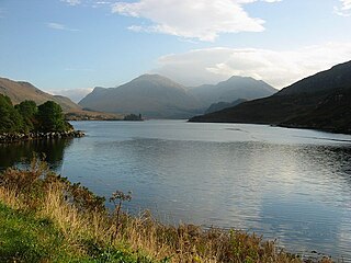
Loch Inver is a 3.62-kilometre-long sea loch in Assynt, Sutherland and is on the northwest coast of Scotland. The loch meets the coastal embayment of Enard Bay at the north end and The Minch, where it meets Soyea Island at its mouth.

Laga is a hamlet on the north shore of Loch Sunart near Acharacle, in Lochaber, in the Highlands of Scotland and is in the council area of Highland.
Bernisdale is a small township, near the head of Loch Snizort Beag, Isle of Skye in the Highlands and Islands and is in the Scottish council area of Highland.

Luib is a crofting and fishing settlement on the south east shore of the sea loch, Loch Ainort near Broadford, on the island of Skye in Scotland. It is in the council area of Highland.The settlement of Dunan is 1 mile directly east of Luib, along the A87 coast road.

Littleferry is a village on the north east shore of Loch Fleet in Golspie, Sutherland, and is in the Scottish council area of Highland. Littleferry lies at the entrance to Loch Fleet, 3 miles southwest of Golspie. A ferry once crossed the narrow channel here. Littleferry was also the scene of a skirmish between a Jacobite force of the Earl of Cromartie and government troops under Ensign John Mackay of Golspie on the eve of the Battle of Culloden in 1746.
Kensaleyre is a scattered crofting township, part of a group of settlements clustered around the A87 road on the shore of Loch Snizort Beag on the Trotternish peninsula of the island of Skye in the Highlands and Islands of Scotland. It is in the council area of Highland.

Kinloch Laggan is a hamlet located at the head of Loch Laggan in Inverness-shire, Scottish Highlands and is in the Scottish council area of Highland. The village is situated 12 miles southwest of Newtonmore.

Diabaig is a remote coastal fishing and crofting township in Wester Ross, in the Northwest Highlands of Scotland. Diabaig lies on the north shore of the sea loch of Loch Diabaig, an inlet off the north side of Loch Torridon, and is in the Highland council area.
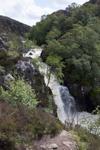
The Falls of Kirkaig are a waterfall in the Northwest Highlands of Scotland in the county of Sutherland. The fall is located on the River Kirkaig, south by southeast of the village of Lochinver, on the main approach footpath to Suilven mountain. About four miles across the hills to the west is Fionn Loch.

Badnaban is a remote scattered coastal village, which lies on the south shore of the sea loch, Loch Inver, in the Assynt district of the west coast of Sutherland, Scottish Highlands. and is in the Scottish council area of Highland.
Fingask Loch is a small lowland freshwater loch that is about three-quarters of a mile from Rae Loch in the valley of the Lunan Burn and is 1.5 miles south-east of Blairgowrie, in Perth and Kinross. Directly to the east is the smaller White Loch, and next to it is the Black Loch.
Stormont Loch is a small irregular lowland freshwater loch, that is partially in-filled. It located in a nature reserve owned by the Scottish Wildlife Trust, on a north-east to south-west orientation and is 2 miles southeast of Blairgowrie in Perth and Kinross.

Monk Myre is a small shallow freshwater lochan and is located 2.5 miles southeast of Blairgowrie in Perth and Kinross.

Fionn Loch is a small irregular-shaped shallow freshwater loch, on a north-west to south-east orientation that is located 3 miles southeast of Lochinver in the Assynt district of Sutherland in Scotland. The loch is located in an area known as the Assynt-Coigach National Scenic Area, one of 40 such areas in Scotland.

Loch Sionascaig is a large irregular shaped, freshwater loch in the remote Coigach area of northern Wester Ross. It is located 5.5 miles southeast of the village of Lochinver and is situated within the Inverpolly Forest.

Loch Lurgainn is a large remote and deep freshwater loch with a crescent shape with its concave side turned to the south. It is located in the Coigach peninsula in Lochbroom, Wester Ross. Loch Lurgainn is located 8 miles north of Ullapool and two miles south of Loch Sionascaig and is 3.5 miles southeast of Enard Bay. The scenic qualities of Coigach, along with neighbouring Assynt, have led to the area being designated as the Assynt-Coigach National Scenic Area, one of 40 such areas in Scotland. The main settlement in the area, located directly to the north-west is Achiltibuie.

Loch Osgaig is a small remote and deep freshwater loch, orientated on north-west to south-east axis, that is located 1 miles south of Enard Bay and 2 mile northeast of Achiltibuie and immediately north west of Loch Bad a' Ghaill. It is located in the Coigach peninsula in Lochbroom, Wester Ross.
