
Loch Lochy is a large freshwater loch in Lochaber, Highland, Scotland. With a mean depth of 70 m (230 ft), it is the third-deepest loch of Scotland.

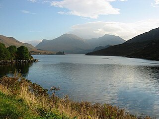
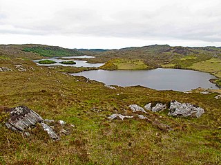
Inverpolly is the name given to a large area of northern Wester Ross in the Northwest Highlands of Scotland, north of Ullapool. The area contains several prominent hills, rising up from a rough landscape of bogs and lochans. From 1961, the area was designated national nature reserve but since 2004, the designation has been limited to the area of Knockan Crag. The area supports a large number of high-quality freshwater loch habitats, the majority of which are oligotrophic. Major peaks in the area include Stac Pollaidh, Cul Mòr, Cul Beag. At the heart of Inverpolly lies the large irregular shaped Loch Sionascaig.
Loch Long is a sea loch situated on the western coast of Scotland, in the Highlands. It is a popular destination for tourists and fishers.
Loch Ossian is a narrow loch that is about 5 kilometres (3.1 mi) long on the north eastern edge of Rannoch Moor, on The Corrour Estate, with its western corner 2 kilometres (1.2 mi) east of Corrour railway station. It is drained by the River Ossian, flowing north into Loch Guilbinn and ultimately to the River Spean at Moy.

Diabaig is a remote coastal fishing and crofting township in Wester Ross, in the Northwest Highlands of Scotland. Diabaig lies on the north shore of the sea loch of Loch Diabaig, an inlet off the north side of Loch Torridon, and is in the Highland council area.
Loch Scoly is a small hill loch, lying to the north-east of Loch Kennard and west of Loch Skiach, on Grandtully Hill within Perth and Kinross, Scotland.
Fingask Loch is a small lowland freshwater loch that is about three-quarters of a mile from Rae Loch in the valley of the Lunan Burn and is 1.5 miles south-east of Blairgowrie, in Perth and Kinross. Directly to the east is the smaller White Loch, and next to it is the Black Loch.

Loch Tilt is a small mountain freshwater loch that sits at the end of Glen Tilt and is located in north-east Perth and Kinross, Scotland. Loch Tilt has a north to south orientation. Loch Tilt is located 10 miles southwest of Braemar.
Stormont Loch is a small irregular lowland freshwater loch, that is partially in-filled. It located in a nature reserve owned by the Scottish Wildlife Trust, on a north-east to south-west orientation and is 2 miles southeast of Blairgowrie in Perth and Kinross.
Pitlyal Loch also known as Round Loch is a small lochan in Sidlaw Hills in Angus. It is located southeast of Long Loch and is almost directly south of Newtyle and 5 miles (8 km) south-by-south-east of Coupar Angus.

Monk Myre is a small shallow freshwater lochan and is located 2.5 miles southeast of Blairgowrie in Perth and Kinross.
Loch Freuchie, also known as Fraoch, the heatherly loch, is a large freshwater loch on a north-west to south-east orientation, within Glen Quaich in Perth and Kinross. The loch is located 2 miles (3.2 km) west of Amulree and 6.5 miles (10.5 km) southeast of Kenmore.

Loch Fender is a small irregular shaped freshwater loch that lies to the north of Loch Freuchie and three miles south-south-east of Amulree and 2+1⁄2 miles from southeast from Milton in Perth and Kinross. For its size it is very deep.

Loch Turret is a large freshwater reservoir on a north-east to south-west orientation, that is located at the head of Glen Turret and 5.39 miles (8.67 km) northwest of Crieff in Perth and Kinross.

Loch Awe is a small loch, located 4 miles south of Loch Assynt and next to the village of Ledmore, within the Assynt area of Sutherland, Scotland. The loch is located in an area along with neighbouring Coigach, as the Assynt-Coigach National Scenic Area, one of 40 such areas in Scotland.
Loch an Tuirc is a large irregular shaped, shallow loch, located about two miles north-by-north-east of Lochinver in the Assynt district of Sutherland, Highland, Scotland. It is one of three lochs in Scotland with the same name. Loch an Tuirc is located in an area known as the Assynt-Coigach National Scenic Area, one of 40 such areas in Scotland.

Cam Loch is an irregularly-shaped freshwater loch, about 5 km long, on a north-west to south-east orientation, located slightly north of the village of Elphin, in the Assynt district of Sutherland, Scotland. The loch is located in an area along with neighbouring Coigach, as the Assynt-Coigach National Scenic Area, one of 40 such areas in Scotland.

Fionn Loch is a small irregular-shaped shallow freshwater loch, on a north-west to south-east orientation that is located 3 miles southeast of Lochinver in the Assynt district of Sutherland in Scotland. The loch is located in an area known as the Assynt-Coigach National Scenic Area, one of 40 such areas in Scotland.

Loch Lurgainn is a large remote and deep freshwater loch with a crescent shape with its concave side turned to the south. It is located in the Coigach peninsula in Lochbroom, Wester Ross. Loch Lurgainn is located 8 miles north of Ullapool and two miles south of Loch Sionascaig and is 3.5 miles southeast of Enard Bay. The scenic qualities of Coigach, along with neighbouring Assynt, have led to the area being designated as the Assynt-Coigach National Scenic Area, one of 40 such areas in Scotland. The main settlement in the area, located directly to the north-west is Achiltibuie.

Loch Osgaig is a small remote and deep freshwater loch, orientated on north-west to south-east axis, that is located 1 miles south of Enard Bay and 2 mile northeast of Achiltibuie and immediately north west of Loch Bad a' Ghaill. It is located in the Coigach peninsula in Lochbroom, Wester Ross.


