Related Research Articles
Taiwan Space Agency, formerly the National Space Organization from 1991 to 2023, is the national civilian space agency of the Republic of China (Taiwan), under the auspices of the National Science and Technology Council. TASA is involved in the development of space technologies and related research.

FalconSAT is the United States Air Force Academy's (USAFA) small satellite engineering program. Satellites are designed, built, tested, and operated by Academy cadets. The project is administered by the USAFA Space Systems Research Center under the direction of the Department of Astronautics. Most of the cadets who work on the project are pursuing a bachelor of science degree in astronautical engineering, although students from other disciplines join the project.

Challenging Minisatellite Payload (CHAMP) was a German satellite launched July 15, 2000 from Plesetsk, Russia and was used for atmospheric and ionospheric research, as well as other geoscientific applications, such as GPS radio occultation, gravity field determination, and studying the Earth's magnetic field.
Constellation Observing System for Meteorology, Ionosphere, and Climate (COSMIC) is a program designed to provide advances in meteorology, ionospheric research, climatology, and space weather by using GPS satellites in conjunction with low Earth orbiting (LEO) satellites. The term "COSMIC" may refer to either the organization itself or the constellation of 6 satellites. The constellation is a joint U.S.-Taiwanese project with major participants including the University Corporation for Atmospheric Research (UCAR), the National Science Foundation, the Naval Research Laboratory (NRL), the Air Force Research Laboratory (AFRL), SRI International on the U.S. side and the National Space Organization (NSPO) on the Taiwanese side.

Ørsted is an Earth science satellite launched in 1999 to study the Earth's geomagnetic field. It is Denmark's first satellite, named after Hans Christian Ørsted (1777–1851), a Danish physicist and professor at the University of Copenhagen, who discovered electromagnetism in 1820.

TacSat-2 is the first in a series of U.S. military experimental technology and communication satellites.TacSat-2 (also known as JWS-D1 was an experimental satellite built by the USAF's Air Force Research Laboratory with an operational life expected to be not more than one year as part of the "Advanced Concept Technology Demonstration" program.
The Space Test Program (STP) is the primary provider of spaceflight for the United States Department of Defense (DoD) space science and technology community. STP is managed by a group within the Advanced Systems and Development Directorate, a directorate of the Space and Missile Systems Center of the United States Space Force. STP provides spaceflight via the International Space Station (ISS), piggybacks, secondary payloads and dedicated launch services.
The Multi-Application Survivable Tether (MAST) experiment was an in-space investigation designed to use CubeSat spacecraft connected by tethers to better understand the survivability of tethers in space. It was launched as a secondary payload on a Dnepr rocket on 17 April 2007 into a 98°, 647 x 782 km orbit. The MAST payload incorporated three picosatellites, named "Ralph," "Ted," and "Gadget," which were intended to separate and deploy a 1 km (0.62 mi) tether. The experiment hardware was designed under a NASA Small Business Technology Transfer (STTR) collaboration between Tethers Unlimited, Inc. (TUI) and Stanford University, with TUI developing the tether, tether deployer, tether inspection subsystem, satellite avionics, and software, and Stanford students developing the satellite structures and assisting with the avionics design.
FedSat was an Australian scientific research satellite launched from Tanegashima Space Center, Japan by a NASDA H-IIA launch vehicle on 14 December 2002. The satellite was developed by the Cooperative Research Centre for Satellite Systems, a cooperative made up of several universities, commercial organisations and government bodies. The ground station was at the Institute for Telecommunications Research, part of the University of South Australia, near Adelaide. Since 2005 it was operated by the Australian Department of Defence.

Radio occultation (RO) is a remote sensing technique used for measuring the physical properties of a planetary atmosphere or ring system. Other satellite carriers onboard GNSS-Radio occultation include CHAMP (satellite), GRACE and GRACE-FO, MetOp and the recently launched COSMIC-2.
The Advanced Research and Global Observation Satellite (ARGOS) was launched on 23 February 1999 carrying nine payloads for research and development missions by nine separate researchers. The mission terminated on 31 July 2003.

C/NOFS, or Communications/Navigation Outage Forecasting System was a USAF satellite developed by the Air Force Research Laboratory (AFRL) Space Vehicles Directorate to investigate and forecast scintillations in the Earth's ionosphere. It was launched by an Orbital Sciences Corporation Pegasus-XL launch vehicle at 17:02:48 UTC on 16 April 2008 and decayed on 28 November 2015.

PicoSAT, launched on September 30, 2001, is a real time tracking satellite. The name "PICO" combines the first letters of all four of its experiments. PICOSat series are designed for a minimum of one year of on-orbit operations.
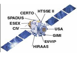
The Coherent Electromagnetic Radio Tomography (CERTO) is a radio beacon which measures ionospheric parameters in coordination with ground receivers. CERTO provides global ionospheric maps to aid prediction of radio wave scattering. CERTO was developed by the Naval Research Lab and is one of the 4 experiment packages aboard the PicoSAT satellite. CERTO provides near–real-time measurements of the ionosphere. CERTO was used for the Equatorial Vortex Experiment in 2013.
The Polymer Battery Experiment (PBEX) demonstrates the charging and discharging characteristics of polymer batteries in the space environment. PBEX validates use of lightweight, flexible battery technology to decrease cost and weight for future military and commercial space systems. PBEX was developed by Johns Hopkins University and is one of four On Orbit Mission Control (OOMC) packages on PicoSat 9:
The On-Orbit Mission Control will be conducted by the Surrey Satellite Technology Ltd ground site in Guildford, UK. The United States Air Force Academy at Colorado Springs, Colorado will operate a backup ground station for PicoSAT satellite to increase the amount of experimental data.

Oceansat-2 is the second Indian satellite built primarily for ocean applications. It was a part of the Indian Remote Sensing Programme satellite series. Oceansat-2 is an Indian satellite designed to provide service continuity for operational users of the Ocean Colour Monitor (OCM) instrument on Oceansat-1. It will also enhance the potential of applications in other areas. The OceanSat-2 mission was approved by the government of India on 16 July 2005.

DRAGONSat is a pair of nanosatellites that will be demonstrating autonomous rendezvous and docking (ARD) in low Earth orbit (LEO) for NASA. It will be gathering flight data with a global positioning system (GPS) receiver strictly designed for space applications to gather flight data in the space environment. ARD is the capability of two independent spacecraft to rendezvous in orbit and dock without crew intervention. One DRAGONSat was built by the University of Texas and the other one was built by Texas A and M University, the Space Shuttle Payload Launcher (SSPL), These satellite projects will rendezvous and dock with each other in space without the benefit of human intervention.
Yuei-An Liou is a Taiwanese professor at the National Central University.

RAX-2 is a CubeSat satellite built as a collaboration between SRI International and students at the University of Michigan College of Engineering. It is the second spacecraft in the RAX mission. The RAX-1 mission ended after approximately two months of operation due to a gradual degradation of the solar panels that ultimately resulted in a loss of power. RAX team members applied the lessons learned from RAX-1 to the design of a second flight unit, RAX-2, which performs the same mission concept of RAX-1 with improved bus performance and additional operational modes. Science measurements are enhanced through interactive experiments with high power ionospheric heaters where FAI will be generated on demand.
References
![]() This article incorporates public domain material from websites or documents of the National Aeronautics and Space Administration .
This article incorporates public domain material from websites or documents of the National Aeronautics and Space Administration .
- ↑ Straus, P. R. (December 2001). "Ionospheric Remote Sensing with the Ionospheric Occultation Experiment (IOX): First Results". American Geophysical Union, Fall Meeting 2001. 2001. Bibcode:2001AGUFMSA32A0676S . Retrieved January 25, 2023.
- 1 2 "Current NASA JPL Missions #Past Missions: IOX". NASA Jet Propulsion Laboratory. Retrieved January 25, 2023.
| | This meteorology–related article is a stub. You can help Wikipedia by expanding it. |
| | This plasma physics–related article is a stub. You can help Wikipedia by expanding it. |
| | This astrophysics-related article is a stub. You can help Wikipedia by expanding it. |