Iowa Primary Road No. 20

Last updated

Iowa Primary 20.svg

Primary Road No. 20
Route information
Existed 1920 – 1926
Highway system
US 20.svg US 20 Iowa 21 Elongated circle 21.svg

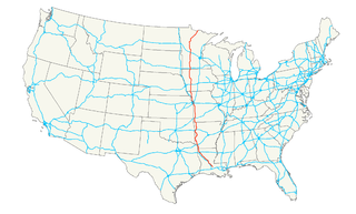
Primary Road No. 20 (No. 20) was the designation of a state highway in Iowa that ran from the Missouri state line at Keokuk to the Minnesota state line near Cresco. No. 20 was in existence for six years—from 1920 to 1926. Today, the route is related to the following highways:

Iowa State of the United States of America

Iowa is a state in the Midwestern United States, bordered by the Mississippi River to the east and the Missouri River and Big Sioux River to the west. It is bordered by six states; Wisconsin to the northeast, Illinois to the east, Missouri to the south, Nebraska to the west, South Dakota to the northwest and Minnesota to the north.

Missouri State of the United States of America

Missouri is a state in the Midwestern United States. With over six million residents, it is the 18th-most populous state of the Union. The largest urban areas are St. Louis, Kansas City, Springfield, and Columbia; the capital is Jefferson City. The state is the 21st-most extensive in area. In the South are the Ozarks, a forested highland, providing timber, minerals, and recreation. The Missouri River, after which the state is named, flows through the center of the state into the Mississippi River, which makes up Missouri's eastern border.

Keokuk, Iowa City in Iowa, United States

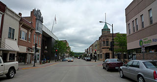
Keokuk is a city in and a county seat of Lee County, Iowa, United States, along with Fort Madison. It is Iowa's southernmost city. The population was 10,780 at the 2010 census. The city is named after the Sauk chief Keokuk, who is thought to be buried in Rand Park. It is in the extreme southeast corner of Iowa, where the Des Moines River meets the Mississippi. It is at the junction of U.S. Routes 61, 136 and 218. Just across the rivers are the towns of Hamilton and Warsaw, Illinois, and Alexandria, Missouri.

Dubuque, Iowa City in Iowa, United States

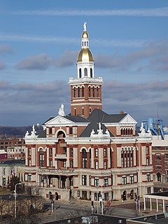
Dubuque is the county seat of Dubuque County, Iowa, United States, located along the Mississippi River. In 2017, the population of Dubuque was 57,637.

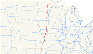
U.S. Highway 52 is a 166-mile-long (267 km) United States highway in northeast Iowa. The route begins at the Dale Gardner Veterans Memorial Bridge over the Mississippi River between Sabula and Savanna, Illinois. From Sabula, it heads north along the Mississippi towards Bellevue and Dubuque. At Dubuque, US 52 briefly shares an expressway with U.S. Route 61 and U.S. Route 151.

Decorah, Iowa City in Iowa, United States

Decorah is a city in and the county seat of Winneshiek County, Iowa, United States. The population was 8,127 at the 2010 census. Decorah is located at the intersection of State Highway 9 and U.S. Route 52, and is the largest community in Winneshiek County.

Related Research Articles

Dubuque County, Iowa County in the United States

Dubuque County is a county located in the U.S. state of Iowa. As of the 2010 census, the population was 93,653. The county seat is Dubuque. The county is named for Julien Dubuque, the first European settler of Iowa.

Cresco, Iowa City in Iowa, United States

Cresco is a city in Howard County, Iowa, United States. The population was 3,868 in the 2010 census, a decline from 3,905 in 2000 census. It is the county seat of Howard County.

U.S. Route 61 highway in the United States

U.S. Route 61 (US 61) is the official designation for a major United States highway which extends 1,400 miles (2,300 km) between New Orleans, Louisiana and the city of Wyoming, Minnesota. The highway generally follows the course of the Mississippi River, and is designated the Great River Road for much of its route. As of 2004, the highway's northern terminus in Wyoming, Minnesota, is at an intersection with Interstate 35 (I-35). Until 1991, the highway extended north on what is now Minnesota State Highway 61 through Duluth and across the Canada–U.S. border, near Grand Portage. Its southern terminus in New Orleans, Louisiana, is at an intersection with Tulane Avenue at South Broad Street. The highway is often called the Blues Highway because it connects Saint Paul, Minnesota; St. Louis, Missouri; Memphis, Tennessee; the Mississippi Delta, and New Orleans.

U.S. Route 71 highway in the United States

U.S. Route 71 is a major north–south United States highway that extends for over 1500 miles in the central United States. This original 1926 route has remained largely unchanged by encroaching Interstate highways. Currently, the highway's northern terminus is in International Falls, Minnesota at the Canada–US border, at the southern end of the Fort Frances-International Falls International Bridge to Fort Frances, Ontario. U.S. Route 53 also ends here. On the other side of the bridge, Trans-Canada Highway 11 is an east–west route. US 71's southern terminus is between Port Barre and Krotz Springs, Louisiana at an intersection with U.S. Route 190.

U.S. Route 55 highway in the United States

U.S. Highway 55 was a north–south United States highway. Though it was part of the original 1926 numbering plan, it was deleted within 10 years.

Avenue of the Saints Highway between St Paul, Minnesota and St Louis, Missouri

The Avenue of the Saints is a 563-mile-long (906 km) highway in the Midwestern United States that connects St. Paul, Minnesota and St. Louis, Missouri.

U.S. Route 63 highway in the United States

U.S. Route 63 is a major 1,286-mile (2,070 km) north–south United States highway primarily in the Midwestern United States. The southern terminus of the route is at Interstate 20 in Ruston, Louisiana. The northern terminus is at U.S. Route 2 in Benoit, Wisconsin, about 60 miles (97 km) east of Duluth, Minnesota.

U.S. Highway 218 is an original United States Highway, created in 1926. Although technically a spur of U.S. Route 18, US 218 neither begins nor ends at US 18, but overlaps US 18 for 8 miles (13 km) near Charles City, Iowa. US 218 begins at U.S. Route 136 in downtown Keokuk and ends 319 miles (513 km) away at Interstate 35 and U.S. Route 14 at Owatonna, Minnesota. A large portion of US 218 in Iowa is part of the Avenue of the Saints, which connects St. Louis, Missouri, and Saint Paul, Minnesota.

U.S. Route 169 highway in the United States

U.S. Route 169 currently runs for 966 miles (1,555 km) from the city of Virginia, Minnesota to Tulsa, Oklahoma at Memorial Drive.

Iowa Highway 17 is a 103-mile-long (166 km) north–south state highway that traverses primarily rural areas in central and north-central Iowa. Iowa 17's southern end is near Granger in Dallas County at a freeway interchange with Iowa Highway 141, and its northern terminus is at an intersection with U.S. Highway 18 at the Kossuth-Hancock county line near Wesley.

Iowa Highway 9 is the most northern of Iowa's east–west highways, traversing the entire northern tier of counties. It runs from the eastern terminus of South Dakota Highway 42 at the South Dakota border east of Sioux Falls, South Dakota near Benclare, to the Wisconsin border at Lansing where it continues as Wisconsin Highway 82. It is largely rural in character, bypassing any large city. Making a few dips north and south, the highway largely follows a very straight east–west alignment.

Area code 563

Area code 563 is a telephone area code for the east central and northeast corner of the state of Iowa, and includes most of the Iowa side of the Quad Cities. The 563 area code was split off from the Area code 319 in 2001, becoming active on March 25, 2001, and finally becoming mandatory on December 2, 2001.

Iowa Highway 4 is a state highway which runs from north to south across the state of Iowa. It is 146 miles (235 km) long, beginning at an intersection with Iowa Highway 44 in Panora and ending at the Minnesota state line north of Estherville. It continues north as Minnesota State Highway 4. The route was created on January 1, 1969, when several route designations were changed to match other states' route numbers. Before 1969, Iowa 4 was known as Iowa 17.

U.S. Highway 20 in Iowa is a major east–west artery which runs across the state, separating the northern third of Iowa from the southern two-thirds. It enters Iowa from Nebraska, concurrent with Interstate 129 and U.S Route 75, crossing the Missouri River at Sioux City. US 20 runs in a more-or-less straight line across Iowa, paralleling 42° 27' N. It leaves Iowa in Dubuque by crossing the Mississippi River into Illinois. Since October 2018, US 20 is a four-lane divided highway for its entire length in Iowa.

Iowa Highway 139 is an 11-mile-long (18 km) highway in northeastern Iowa. It begins at Iowa 9 east of Cresco and ends at the Minnesota state line, where it continues northward as Minnesota State Highway 139. It crosses the Upper Iowa River near Kendallville. The roadway has been a part of the state's primary highway system since its inception in 1920; however, it has only been known as Iowa 139 since 1930. From 1935 to 1980, the highway extended south to Protivin.