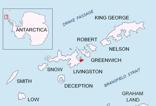
Nikopol Point is a snow-free point on the south coast of Byers Peninsula, Livingston Island in the South Shetland Islands, Antarctica projecting 650 m east-southeastwards into Bransfield Strait and linked by a spit to Vietor Rock to the south. The area was visited by early 19th century sealers who had dwellings at the foothills of nearby Sealer Hill.

Rila Point is a low, ice-free point on the south coast of Moon Bay, projecting 330 m west-northwestwards from Burgas Peninsula on Livingston Island in the South Shetland Islands, Antarctica, and forming the east side of the entrance to Bruix Cove. The point is named after Rila Mountain, Bulgaria.

Avitohol Point is a point on the north coast of Livingston Island, Antarctica projecting 1.15 km into Hero Bay to form the west side of the entrance to Skravena Cove and the southeast side of the entrance to Prisoe Cove. The point is named after the legendary Khan Avitohol listed in the 8th Century ‘Nominalia of the Bulgarian Khans’, who laid the foundations of the Bulgarian statehood in Europe in 165 AD.

Iratais Point is a point forming both the south extremity and the vertex of the V-shaped Desolation Island situated in the entrance to Hero Bay, Livingston Island, Antarctica. Separated from Miladinovi Islets to the south by Neck or Nothing Passage.

Ballester Point is a point forming the south side of the entrance to Johnsons Dock and the northeast side of the entrance to Española Cove in Hurd Peninsula, Livingston Island in the South Shetland Islands, Antarctica. The area was visited by early 19th century sealers operating from Johnsons Dock.

Mezdra Point is the ice-free point on the northwest coast of Snow Island in the South Shetland Islands, Antarctica situated 1.41 km southwest of Cape Timblón, and 1.91 km northeast of Irnik Point.

Ugain Point is the point on the west coast of Rugged Island in the South Shetland Islands, Antarctica separating Smyadovo Cove to the north and Bogomil Cove to the south. Situated 1.76 km north-northwest of Benson Point, 970 m north of Kokalyane Point and 1.55 km south of Cape Sheffield.

Ivan Vladislav Point is a point on the north coast of Rugged Island off the west coast of Byers Peninsula of Livingston Island in the South Shetland Islands, Antarctica formed by an offshoot of Cherven Peak. Situated 1.63 km west-northwest of Herring Point, 400 m east-northeast of Simitli Point, and 3.27 km east-southeast of Cape Sheffield.

Radev Point is a point in the southeast extremity of Rugged Island off the west coast of Byers Peninsula of Livingston Island in the South Shetland Islands, Antarctica. It is situated 4.5 km east of Benson Point, 1.05 km southwest of Vund Point, and 2.62 km west by south of Laager Point, Livingston Island.

Vund Point is the point forming the east extremity of Rugged Island off the west coast of Byers Peninsula of Livingston Island in the South Shetland Islands, Antarctica. The area was visited by early 19th century sealers.

Sevar Point is a point on the south coast of Byers Peninsula on Livingston Island in the South Shetland Islands, Antarctica situated 1.9 km east-southeast of Devils Point, 2.71 km west of Nikopol Point, and 2.97 km northeast of Long Rock in Morton Strait. It is surmounted by Wasp Hill on the north-northeast, Sealer Hill on the east-northeast, and forms the east side of the entrance to Raskuporis Cove.

Dometa Point is a point on the south coast of Byers Peninsula on Livingston Island in the South Shetland Islands, Antarctica situated 4.3 km west-northwest of Rish Point, 1.2 km southwest of Negro Hill, 4.6 km southeast of Chester Cone, and 4.2 km east-northeast of Nikopol Point.

Isbul Point is a narrow rocky point projecting 600 m from the coast of Ray Promontory into Svishtov Cove in the northwest extremity of Byers Peninsula, Livingston Island in the South Shetland Islands, Antarctica. It is situated 750 m east-northeast of Start Point, 1.46 km southwest of Essex Point and 1.23 km west-southwest of Kardzhali Point. Forming the east side of the entrance to Belene Cove.

Voyteh Point is the point forming the east side of the entrance to Richards Cove on the north coast of Ray Promontory in the northwestern part of Byers Peninsula on Livingston Island in the South Shetland Islands, Antarctica. It is surmounted by Sàbat Hill. The area was visited by early 19th century sealers.

Aglen Point is a rocky point forming the west side of the entrance to Richards Cove on the north coast of Ray Promontory in the northwestern part of Byers Peninsula on Livingston Island in the South Shetland Islands, Antarctica. Situated 470 m west of Voyteh Point and 1.6 km east of Essex Point. The area was visited by early 19th century sealers.

Vardim Rocks are a group of rocks situated on the south side of Hell Gates, facing Devils Point in the southwest extremity of Byers Peninsula on Livingston Island in the South Shetland Islands, Antarctica. Extending 1.3 km (0.81 mi) in east-west direction. The two principal islets in the group, Demon and Sprite, are extending 420 by 400 m and 270 by 150 m respectively, with surface area of the former 9 hectares. The area was visited by early 19th century sealers.

Yasen Point is the sharp, rocky point on the south coast of Livingston Island in the South Shetland Islands, Antarctica, forming the west side of the entrance to Mateev Cove. Situated on the east side of the small ice-free promontory ending in Hannah Point to the west.

Bizone Rock is the rock off Snow Island in the South Shetland Islands, Antarctica extending 120 m in southeast-northwest direction and 100 m wide. It is the largest and southeasternmost in a group of several rocks extending 1.84 km in southeast-northwest direction and 1 km in southwest-northeast direction.

Razdel Point is the ice-covered point on the southwest side of the entrance to Zapalnya Cove and northeast side of the entrance to Nikolov Cove on the southeast coast of Smith Island in the South Shetland Islands, Antarctica. The point is named after the settlements of Razdel in Northeastern and Southeastern Bulgaria.

Velikan Point is the ice-covered point on the southwest side of the entrance to Nikolov Cove on the southeast coast of Smith Island in the South Shetland Islands, Antarctica. The point is named after the settlement of Velikan in Southern Bulgaria.


