Iselborgh | |
---|---|
![]() Cairn na Burgh Beag, a possible location for Iselborgh | |
Coordinates | 56°31′05″N6°22′48″W / 56.518°N 6.38°W |
Argyll and Bute showing the location of Cairnburgh Castle. Tiree is to the west, Mull to the east and Coll to the northwest. |
Iselborgh or Isleborg is a fortification of uncertain location on the western seaboard of Scotland. Suggested sites for the castle are: Cairn na Burgh Beag, the smaller islet that forms part of Cairnburgh Castle; a former castle in Loch an Eilien on Tiree; and somewhere on the nearby islands of Mull and Coll. [1]
There are a few written records of the castle's existence from the 14th to the late 15th century indicating its presence off the coast of Argyll. The name may mean simply "island fort".
The first certain reference was in 1343 when the castle was granted by David II to John of Islay, Lord of the Isles along with Cairnburgh in the Treshnish Isles and Dùn Chonnuill in the Garvellachs. [2] There is also mention in the 13th century Hákonar saga Hákonarsonar of four castles held by Ewen MacDougall of Lorn from the Norwegian crown. Supposedly, MacDougall met the Scottish king Alexander II circa 1249 and "refused a demand for Cairburngmore and three other castles" so it is possible that Iselborgh was one of them. [1]
In 1354 John Gallda MacDougall of Lorn is recorded as giving up any claim to the castles of "Kerneburch and Hystylburch" to John of Islay, the latter being a presumed reference to Iselborgh. [3]
In a 1495 confirmation of a 1390 charter, John of Islay's son Donald granted "command and possession of the castles of Kernaborg and Isleborg together with small Floda and Lunga" to Lachlan Lùbanach Maclean of Duart. [2] [3] [4]
Hector MacLean of Duart was recorded as the "heritable keeper of the following castles" in 1493:- "Dowart in Mull; Carneburgh in the Treshnish Isles off the north-west coast of Mull; Dunconnell in Scarba; Dunkerd in the Garveloch Isles near Scarba; and Isleborg, the locality of which is uncertain". [5] [3] [a]
"Borgh" is evidently from Old Norse : borg meaning fort. The most straightforward rendering of Iselborg is therefore simply "island fort". Another possibility is that "isel" is a rendering of Scottish Gaelic : iosal meaning "low". There are 46 Scottish placenames that contain this Gaelic word but in no such case does it form the commencement of the name. "Isel" could conceivably come from Old Norse : ila, a well or spring. [3]
An unusual feature of the Cairnburgh Castle its that its defences straddle both the island of Cairn na Burgh Mòr itself and its smaller companion isle. Cairn na Burgh Mòr contains a barrack block, chapel, courtyard and guard-house and Cairn na Burgh Beag has another guard-house and a well. [6] [7] Given that "small Floda and Lunga" mentioned in 1495 are also in the Treshnish Isles, Duncan and Brown concluded that Iselborg "certainly lay, with Cairnburgmore, in the Treshnish Group". [8] In 1980 the RCAHMS also believed that "there appear to be good grounds for accepting the view that Isleborgh is an early name" for Cairn na Burgh Beag. [1]
In 1903 Erskine Beveridge had concluded that Loch an Eilien on Tiree was a more likely location for Iselborg. [1] The loch is near the modern settlement of Heylipol [10] which name, with a variety of spellings such as Hilibol, is the second most attested placename on Tiree of Norse origin. [9] Holliday speculates that the first syllable has a similarity to "isel" and that the possibility of isel having a relationship to the Norse ila may be evidence for the two being one and the same. [11] There was certainly a substantial fortification at this location on Tiree, the Old Statistical Account of the late 18th century referring to castle with a drawbridge there at some point in the past. [9] John of Fordun also referred to a turris est fortissima (very strong tower) on the island in the 14th century and Dean Monro in his 16th century Description to "ane fresh water loch, with ane auld castell". [12] [13] [14] By the late 17th century however, it lay in ruins. [15] [16] There is a reference to the "Inch of Teinlipeil" (probably the "island of Hilibol") in relation to the death of Sir Donald Galda MacDonald of Lochalsh in 1519 [17] [b] but otherwise the castle's name is unrecorded.
The challenge with this option is that although the castle on Tiree clearly had a military importance, the other castles and locations mentioned along with Iselborgh - Dùn Chonnuill, Cairnburgh, Duart, Floda and Lunga are all islands or on the coast and their positions commanded the sea lanes. [16] Loch an Eilien is a freshwater body about 1 km (0.62 mi) from the coast and the castle was on an island in that loch (now a peninsula) with no access to the sea. [12] [10] The Old Statistical Account describes the castle on Tiree as being similar to Breachacha Castle on Coll, [9] although this too is on the coast. Nonetheless, Holliday's conclusion is that if Iselborgh is a "name with no place" [18] and the castle on Tiree is a place with an uncertain name then this is the "most plausible" conclusion to the puzzle. [18]
R.W. Munro, writing in 1973, suggested that there was not "sufficient evidence that Isleborg 'certainly' lay in the Treshnish group, as Kernaborg undoubtedly does; why should there be two castles there?... If therefore we have to look beyond the Treshnish group, why not in Mull, or even in neighbouring Coll or Tiree?" [1] [c] but does not appear to have offered any specific suggestions.
Argyll and Bute is one of 32 unitary council areas in Scotland and a lieutenancy area. The current lord-lieutenant for Argyll and Bute is Jane Margaret MacLeod. The administrative centre for the council area is in Lochgilphead at Kilmory Castle, a 19th-century Gothic Revival building and estate. The current council leader is Councillor Jim Lynch.
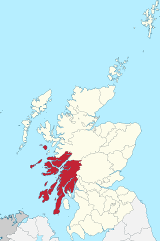
Argyll, sometimes called Argyllshire, is a historic county and registration county of western Scotland. The county ceased to be used for local government purposes in 1975 and most of the area now forms part of the larger Argyll and Bute council area.
The Garvellachs or Isles of the Sea form a small archipelago in the Inner Hebrides of Scotland. The islands include Garbh Eileach, Dùn Chonnuill and Eileach an Naoimh. Part of the Argyll and Bute council area, they lie in Firth of Lorne west of Lunga and northwest of Scarba and have been uninhabited since the 19th century.
Lord of the Isles or King of the Isles (Scottish Gaelic: Triath nan Eilean or Rìgh Innse Gall; Latin: Dominus Insularum) is a title of nobility in the Baronage of Scotland with historical roots that go back beyond the Kingdom of Scotland. It began with Somerled in the 12th century and thereafter the title was held by a series of his descendants, the Norse-Gaelic rulers of the Isle of Man and Argyll and the islands of Scotland in the Middle Ages. They wielded sea-power with fleets of galleys (birlinns). Although they were, at times, nominal vassals of the kings of Norway, Ireland, or Scotland, the island chiefs remained functionally independent for many centuries. Their territory included much of Argyll, the Isles of Arran, Bute, Islay, the Isle of Man, Hebrides, Knoydart, Ardnamurchan, and the Kintyre peninsula. At their height they were the greatest landowners and most powerful lords after the kings of England and Scotland.
Scarba is an island, in Argyll and Bute, Scotland, just north of the much larger island of Jura. The island has not been permanently inhabited since the 1960s.
Belnahua is one of the Slate Islands, in the Firth of Lorn in Scotland, known for its deserted slate quarries. The bedrock that underpins its human history is part of the Scarba Conglomerate Formation and its value has been on record since the 16th century. Likely uninhabited before commercial quarrying commenced, under the control of the Stevenson family during the 19th century the population expanded to over 150 before the island was abandoned again in 1914.
The Treshnish Isles are an archipelago of small islands and skerries, lying west of the Isle of Mull, in Scotland. They are part of the Inner Hebrides. Trips to the Treshnish Isles operate from Ulva Ferry, Tobermory, Ardnamurchan and Tiree.
Clan Maclean is a Highlands Scottish clan. They are one of the oldest clans in the Highlands and owned large tracts of land in Argyll as well as the Inner Hebrides. Many early MacLeans became famous for their honour, strength and courage in battle. They were involved in clan skirmishes with the Mackinnons, Camerons, MacDonalds and Campbells, as well as all of the Jacobite risings.
Garbh Eileach is an uninhabited island in the Inner Hebrides of the west coast of Scotland that lies in the Firth of Lorn between Mull and Argyll. With an area of 142 ha it is the largest of the Garvellachs and reaches a maximum elevation of 110 m (361 ft) above sea level.
Cairn na Burgh Mòr is one of the Treshnish Isles in the Inner Hebrides of Scotland.
Dùn Chonnuill is a small island in the Garvellachs in the Firth of Lorn, Scotland.
Cairn na Burgh Beag is one of the Treshnish Isles in the Inner Hebrides, Scotland.
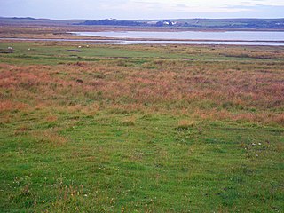
Loch Gruinart is a sea loch on the northern coast of isle of Islay in Scotland. Land at the head of the loch, Gruinart Flats, is a designated nature reserve owned by the RSPB. It is an important winter roosting site for barnacle geese. Ardnave Point is a coastal promontory near the mouth of the loch on the northwest of Islay.
Sir John Maclean, 4th Baronet of Duart and Morvern (1670–1716) was the 20th Clan Chief of Clan Maclean from 1674 to 1716. He was the 16th and last Laird of Duart, when in 1691 he lost Castle Duart to Archibald Campbell, 1st Duke of Argyll. The castle wasn't recovered by Clan Maclean until 1912 until it was purchased by Fitzroy Donald Maclean, 221 years later.
Lachlan Catanach Maclean was the 11th Clan Chief of Clan MacLean from 1515 until his murder in 1523.
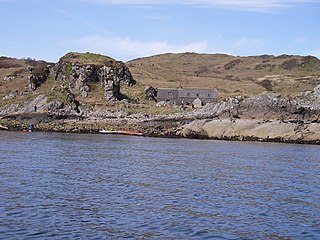
Cairnburgh Castle is a ruined castle that is located on the islands of Cairn na Burgh Mòr and Cairn na Burgh Beag, Argyll and Bute, Scotland. These islands are at the northern extremity of the Treshnish Isles at the mouth of Loch Tuath, Mull north of Iona. 1991's The Changing Scottish Landscape characterizes it as "one of the most isolated fortifications in Britain...[and] also one of the strangest."
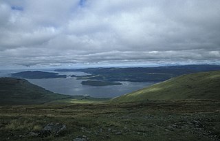
Loch na Keal, meaning Loch of the Kyle, or Narrows, also Loch of the Cliffs, is the principal sea loch on the western, or Atlantic coastline of the island of Mull, in the Inner Hebrides, Argyll and Bute, Scotland. Loch na Keal extends over 20 kilometres (12 mi) inland, almost bisecting Mull, and extending to within 5 km (3 mi) of the eastern shore. The loch gives its name to the Loch na Keal National Scenic Area, one of forty national scenic areas in Scotland.