History
In the course of the settlement of the Ore Mountains, a fortifications was built on a rocky spur above the confluence of the Wildbach stream and the river Mulde. Archaeological finds indicate that this site already existed in the 12th century. The name "Isenburg" goes back to the name Vas and indicates either iron mining, which took place in the vicinity (see also: Bad Schlema Show Mine), or it meant "iron" in the sense of "impregnable".
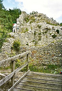
Little is known about the history of spur castle and its violent destruction. There are no verified, documented references. Oral traditions - the first account dates to 1738 - called the Isenburg a "robber castle," the "Old Castle" (Altes Schloss) and the "Iron Castle" (Eisenburg), from which its present name is derived. But there are no medieval sources. The castle had been destroyed by the 14th century and was never rebuilt. Its ruins were probably used from the 15th to 17th centuries as shelters for the local population during times of conflict. Around 1750, the remains of the castle were demolished to build the stone church in Wildbach.
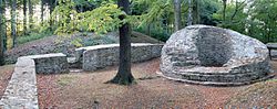
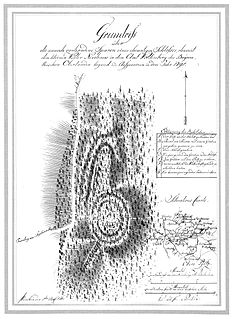
In 1934 the remains of the ramparts were exposed by the Reich Labour Service. The foundations of the ramparts and the remains of the round bergfried were restored in 1993.
Access
The recommended way to visit the castle ruins is by foot from Hartenstein railway station which takes about 30 minutes. Only about 200 metres from the station is Stein Castle. At this spot the route crosses the Zwickauer Mulde river to a point immediately below Schloss Wolfsbrunn. Here the route turns left and winds through the Poppenwald upstream and parallel to the Mulde. After a short, but steep, climb known as "Gentle Henry" (Sanfter Heinrich), the path forks. Keeping right, the route passes the Wildbach Church on an easy forest path. Here there are signs to the ruins which are another 700 metres further on.
The left-hand fork leads via a wild and romantic narrow path on top of the river bank of the Mulde to the same destination. This path is called the "Raubrittersteig" ("Robber Baron Climb") and is one of the most attractive walks in the Mulde Valley.
Very close to the Isenburg, but on the opposite bank of the Mulde, is the Prince's Cave. The path continues further upstream towards Bad Schlema where a radium spring is reached after about 1 kilometre.
This page is based on this
Wikipedia article Text is available under the
CC BY-SA 4.0 license; additional terms may apply.
Images, videos and audio are available under their respective licenses.

Aue is a small town in Germany at the outlet of the river Schwarzwasser into the river Zwickauer Mulde in the Ore Mountains, and has roughly 16,000 inhabitants. It was merged into the new town Aue-Bad Schlema in January 2019. Aue was the administrative seat of the former district of Aue-Schwarzenberg in Saxony, and is part of the Erzgebirgskreis since August 2008. It belongs to the Silberberg Town League
The ruins of Alt-Eberstein are the remains of the former Schloss Eberstein, located on a hill near the town of Ebersteinburg and directly upstream of the modern city of Baden-Baden, in the state of Baden-Württemberg, Germany. The original structure was built in 1100 as the primary residence of the Counts of Eberstein, but by the end of the 16th century had been abandoned and much of the castle was torn down to provide materials for other structures. Presently it is a German national monument and a State Palace of Baden-Wuerttemberg.
Hodenhagen Castle is the site (Burgstall) of a former lowland castle (Niederungsburg) built in the 13th century in the vicinity of Hodenhagen in the German state of Lower Saxony. This medieval manor house only lasted just under 100 years and was destroyed in 1289.
Bunkenburg was a castle built during the 13th and 14th centuries in the shape of a circular fort located on the banks of the Aller opposite Ahlden in north Germany. Only a section of the rampart, roughly 60 metres long and 3 metres high, exists today. The name of the castle is probably derived from the material, bog iron, used for its construction and known in common parlance as Bunke.

The Battert is a hill, 567.9 m above sea level (NHN), on the western edge of the Northern Black Forest north of Baden-Baden in Germany. On its western slopes are the ruins of Hohenbaden Castle, on the southern side is the climbing area and nature reserve called the Battert Rocks (Battertfelsen). On the hill ridge are the remains of a circular rampart, probably built by Celtic settlers. On the eastern side lies the village of Ebersteinburg.
The Zwickau–Schwarzenberg railway is a main line railway in the German state of Saxony. It extends from Zwickau through the valleys of the Zwickauer Mulde and the Schwarzwasser via Bad Schlema and Aue to Schwarzenberg. It opened in 1858 and it is one of the oldest railways in Germany. It is now served by Regionalbahn trains, operated by Erzgebirgsbahn between Zwickau and Johanngeorgenstadt.
The Wiesenburg Castle is castle located in the Wiesenburg district of Wildenfels, Saxony, on a hill overlooking the eastern shore of the Mulde river. The castle protects the bridge across the Mulde to Schönau and Wildenfels.

The Peterskopf, near the Palatine county town of Bad Dürkheim in the German state of Rhineland-Palatinate, is a 487-metre-high hill in the Haardt mountains. On its summit is the Bismarck tower.

The ruins of Alt-Trauchburg Castle, also called the Alttrauchburg or Trauchburg, lie above the Weitnau hamlet of Kleinweiler in the county of Oberallgäu in Swabia. Large parts of the original stone walls of the high- to post-medieval castle remain. The ruins are some of the best preserved in the Allgäu region of Germany.

Grenzau Castle is a ruined spur castle at 250 m above sea level (NN) near Höhr-Grenzhausen in the county of Westerwaldkreis in the state of Rhineland-Palatinate. It is the only castle in Germany with a triangular bergfried.
The Burgstall of Schlosshügel near Weidenberg is a lost hill castle or circular rampart site of the type known as a motte from the Early Middle Ages. It lies on the southern perimeter of the Fichtel Mountains at a height of 699 metres above sea level (NN) above the village of Sophienthal, which is part of the market borough of Weidenberg in the Upper Franconia county of Bayreuth in Bavaria. The burgstall or lost castle site was partly investigated by means of an archaeological test excavation and was also mapped several times in the past.
The Ruins of Radegg are the ruins of a spur castle built around the year 1200 in the Canton of Schaffhausen, Switzerland and destroyed around the year 1300. It is located high above the Wangental on a spur of the Rossberg which drops off steeply on three sides in Osterfingen in the municipality of Wilchingen.

Trevelgue Head, also known as Porth Island, is a headland a short distance north-east of Newquay, in Cornwall, England. It is adjacent to Porth and is at the eastern end of Newquay Bay.

The burgstall of the Altes Schloss is the site of an old castle near the village of Affalterthal in Bavaria, that was probably built in the High Middle Ages for the nobility. It lies within the municipality of Egloffstein in the Upper Franconian county of Forchheim.

The small ringwork of the Altes Schloss is all that remains of a, now levelled, early medieval fortification on one of the projecting hill spurs of the Mirsberg Heights on the Lange Meile in the valley of the Eggerbach. The spur is called the Schlossberg. The old castle site lies at a height of 493.4 m above sea level (NN) around 935 metres south-southeast of the Roman Catholic parish church of St. Margareta of Drügendorf in the Upper Franconian municipality of Eggolsheim in Bavaria, Germany. No historical or archaeological information about this hillfort exists, and there have been no finds that might be able to be used to date the site. Based on the design of the fortification it has been tentatively dated to the Carolingian-Ottonian period. All that has survived is a ringwork with an outer ditch in places. The fortification is protected today as heritage site number D-4-6132-0125: "Early Medieval Ringwork".

The Niederburg at Kobern, also called the Niedernburg, Unterburg or Neue Burg, is a hill castle above the municipality of Kobern-Gondorf in the county of Mayen-Koblenz in the German state of Rhineland-Palatinate.