Ruhleben is a Berlin U-Bahn station, the western terminus of the U 2 line. Named after the adjacent Ruhleben neighbourhood, it is located in the Westend district close to the border with Spandau.

Kojice is a village in the Pardubice Region of the Czech Republic. It has around 400 inhabitants.

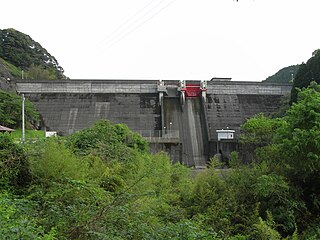
Hakusui Dam (白水ダム) is a concrete gravity dam on the upper reaches of the Ōno River in Taketa, Ōita Prefecture, Japan. It was constructed in 1938, and is 86 m wide and 14 m tall.

Hōnen'ike Dam is a multiple-arch dam in the Sanuki Mountain range at Kan'onji, Kagawa Prefecture, Japan. The reservoir it creates is used for irrigation. Construction began in 1926 and was completed in 1930. The dam is 32 m high and has a crest length of 158 m. It is supported by six arched buttresses. Some renovation work has been needed to control leakage; special care has been taken due to its status as a cultural asset.
Wierzchłowce is a village in the administrative district of Gmina Sokółka, within Sokółka County, Podlaskie Voivodeship, in north-eastern Poland, close to the border with Belarus.

The Hosobidani Dam (細尾谷ダム) is a dam in Hichisō, Gifu Prefecture, Japan, completed in 1926.

Górki Śląskie is a village in the administrative district of Gmina Nędza, within Racibórz County, Silesian Voivodeship, in southern Poland. It lies approximately 7 kilometres (4 mi) east of Nędza, 13 km (8 mi) north-east of Racibórz, and 46 km (29 mi) west of the regional capital Katowice.

Kleszczewo is a village in the administrative district of Gmina Bledzew, within Międzyrzecz County, Lubusz Voivodeship, in western Poland. It lies approximately 7 kilometres (4 mi) south of Bledzew, 14 km (9 mi) west of Międzyrzecz, 32 km (20 mi) south of Gorzów Wielkopolski, and 59 km (37 mi) north of Zielona Góra.
Hồng Giang is a commune (xã) and village in Lục Ngạn District, Bắc Giang Province, in northeastern Vietnam.
Kougawa Dam is a dam in Kagoshima Prefecture, Japan, completed in 1973.

Hachisu Dam (蓮ダム) is a dam in southwestern Matsuzaka, Mie Prefecture, Japan, completed in 1991.
Port Said University is a university in Port Said, Egypt. It was established in 2010, after the decision of the Egyptian president to establish this university to succeed Port Said's branch of the Suez Canal University which was established in 1976.

Hitotsuse Dam is a dam in Saito, Miyazaki Prefecture, Japan, completed in 1963.

Iwase Dam is a dam in Kobayashi, Miyazaki Prefecture, Japan, completed in 1967.

Kamishiiba Dam is a dam in Miyazaki Prefecture, Japan. It was Japan's first arch dam and required significant sacrifices to build.

Ikusaka Dam is a dam in the village of Ikusaka, Nagano Prefecture, Japan, completed in 1964.

Inagawa Dam is a dam in Ōkuwa, Nagano Prefecture, Japan, completed in 1977.

Hisashi Dam is a dam in the Ōita Prefecture, Japan, completed in 1979. It is an Embankment Dam with the purpose of being an irrigational and industrial water dam. The dam is 40 metres high and retains 4 800 000 m³ of water over a 263 metre crest length. The volume of the dam is 431 000 m³ and the surface area of lake Hisashi is 370 000 m².

Inaba Dam is a dam in Taketa, Ōita Prefecture, Japan, completed in 2010.

Kitagawa Dam is a dam in the Saiki, Ōita, Japan, completed in 1962. It spans the Kita River, a class A river, in the Gokase River drainage system. It is managed by Ōita Prefecture, and it is an 82.0 meter tall concrete arch dam. It is the largest dam in the Gokase River drainage system, and it was built with government subsidies with the goal of flood control and hydroelectric power generation for the Kita River basin. The man-made lake formed by the dam is the largest such reservoir of any dam administered by the prefecture, but it is simply called the Kitagawa Dam Lake and has no nickname. Despite that in 2005 it was selected by the Dam Waters Environment Development Center Foundation as one of the top one hundred reservoirs.