
The British Isles are a group of islands in the North Atlantic Ocean off the north-western coast of continental Europe, consisting of the islands of Great Britain, Ireland, the Isle of Man, the Inner and Outer Hebrides, the Northern Isles, and over six thousand smaller islands. They have a total area of 315,159 km2 (121,684 sq mi) and a combined population of almost 72 million, and include two sovereign states, the Republic of Ireland, and the United Kingdom of Great Britain and Northern Ireland. The Channel Islands, off the north coast of France, are normally taken to be part of the British Isles, even though geographically they do not form part of the archipelago. Under the UK Interpretation Act 1978, the Channel Islands are clarified as forming part of the British Islands, not to be confused with the British Isles.

The Isle of Man or Mann, is a self-governing British Crown Dependency in the Irish Sea, between Great Britain and Ireland. As head of state, Charles III holds the title Lord of Mann and is represented by a Lieutenant Governor. The government of the United Kingdom is responsible for the isle's military defence and represents it abroad.

Madison County is a county located in the U.S. state of New York. As of the 2020 census, the population was 68,016. Its county seat is Wampsville. The county is named after James Madison, the fourth president of the United States, and was first formed in 1806. The county is part of the Central New York region of the state.
Oneida County is a county in the state of New York, United States. As of February 26, 2024, the population was 226,654. The county seat is Utica. The name is in honor of the Oneida, one of the Five Nations of the Iroquois League or Haudenosaunee, which had long occupied this territory at the time of European encounter and colonization. The federally recognized Oneida Indian Nation has had a reservation in the region since the late 18th century, after the American Revolutionary War.

Vilas County is a county in the state of Wisconsin, United States. As of the 2020 census, the population was 23,047. Its county seat is Eagle River. The county partly overlaps the reservation of the Lac du Flambeau Band of Lake Superior Chippewa.
Orleans is a town in Jefferson County, New York, United States. The population was 2,789 at the 2010 census, up from 2,463 in 2000. The town is located in the northern part of the county and is north of Watertown. Orleans is named after the commune of Orléans in France.

Minocqua is a town in northwestern Oneida County, Wisconsin, United States. The population was 4,414 as of 2018. The census-designated place of Minocqua and the unincorporated community of Rantz are both located in the town. Minocqua is commonly referred to as "The Island City."

The Mohawk River is a 149-mile-long (240 km) river in the U.S. state of New York. It is the largest tributary of the Hudson River. The Mohawk flows into the Hudson in Cohoes, New York, a few miles north of the state capital of Albany. The river is named for the Mohawk Nation of the Iroquois Confederacy. A major waterway, in the early 19th century, the river's east-west valley provided the setting and water for development of the Erie Canal, as a key to developing New York. The largest tributary, the Schoharie Creek, accounts for over one quarter (26.83%) of the Mohawk River's watershed. Another main tributary is the West Canada Creek, which makes up for 16.33% of the Mohawk's watershed.

Oneida Lake is the largest lake entirely within New York state, with a surface area of 79.8 square miles (207 km2). The lake is located northeast of Syracuse and near the Great Lakes. It feeds the Oneida River, a tributary of the Oswego River, which flows into Lake Ontario. From the earliest times until the opening of the Erie Canal in 1825, the lake was part of an important waterway connecting the Atlantic seaboard of North America to the continental interior.

The Oneida people are a Native American tribe and First Nations band. They are one of the five founding nations of the Iroquois Confederacy in the area of upstate New York, particularly near the Great Lakes.

The Oswego River is a river in upstate New York in the United States. It is the second-largest river flowing into Lake Ontario. James Fenimore Cooper’s novel The Pathfinder, or The Inland Sea is set in the Oswego River valley.

Oneida is an unincorporated community and census-designated place (CDP) in Clay County, Kentucky, United States. Its population was 238 at the 2020 census. It is the home of Oneida Baptist Institute. Goose Creek, the Red Bird River, and Bullskin Creek confluence to form the South Fork of the Kentucky River a few hundred yards from the center of the town.

The Bay of Isles is a bay 9 miles (14 km) wide and receding 3 miles (5 km), lying between Cape Buller and Cape Wilson along the north coast of South Georgia. It was discovered in 1775 by a British expedition under James Cook and so named by him because numerous islands lie in the bay. Of South Georgia's 31 breeding bird species, 17 are found here.

USS Oneida (APA-221) was a Haskell-class attack transport in service with the United States Navy from 1944 to 1946. She was scrapped in 1975.
Oneida Indian Nation of New York v. County of Oneida, 414 U.S. 661 (1974), is a landmark decision by the United States Supreme Court concerning aboriginal title in the United States. The original suit in this matter was the first modern-day Native American land claim litigated in the federal court system rather than before the Indian Claims Commission. It was also the first to go to final judgement.

Oneida FC is a soccer club based in East Boston. The organisation was established in 2011 and plays its home games at East Boston Memorial Stadium, owned by the city of Boston. The field also hosts American football and baseball games.
Lower South Bay, commonly called South Bay, is a hamlet on the southwest corner of Oneida Lake, Oneida County, New York, United States. It is opposite North Bay, and is surrounded by many islands to the west, north and east, including Geersbeck Island, Hall Island, Glosky Island, Schroeppel Island, Denmans Island and Long Island. Lower South Bay also lies near the town of Cicero, approximately two miles west.
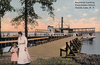
Frenchman Island is a 26-acre (11 ha) island located in Oneida Lake in Oswego County, New York, United States. It was known historically as "Seven Mile Island" during the American Revolution and by the Onondaga people as Kah-wha-nah-kee.
