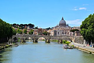
The Tiber is the third-longest river in Italy and the longest in Central Italy, rising in the Apennine Mountains in Emilia-Romagna and flowing 406 km (252 mi) through Tuscany, Umbria, and Lazio, where it is joined by the River Aniene, to the Tyrrhenian Sea, between Ostia and Fiumicino. It drains a basin estimated at 17,375 km2 (6,709 sq mi). The river has achieved lasting fame as the main watercourse of the city of Rome, which was founded on its eastern banks.

Ostia Antica is an ancient Roman city and the port of Rome located at the mouth of the Tiber. It is near modern Ostia, 25 km (16 mi) southwest of Rome. Due to silting and the invasion of sand, the site now lies 3 km (2 mi) from the sea. The name Ostia derives from Latin os 'mouth'.

Fiumicino is a town and comune in the Metropolitan City of Rome, Lazio, central Italy, with a population of 80,500 (2019). It is known for being the site of Leonardo da Vinci–Fiumicino Airport, the busiest airport in Italy and the ninth-busiest in Europe, which serves Rome and much of central Italy.

Tiber Island is the only river island in the part of the Tiber which runs through Rome. Tiber Island is located in the southern bend of the Tiber.
Cerveteri is a comune (municipality) in the Metropolitan City of Rome Capital, in the Italian region of Lazio. Known by the ancient Romans as Caere, and previously by the Etruscans as Caisra or Cisra, and as Agylla by the Greeks, its modern name derives from Caere Vetus used in the 13th century to distinguish it from Caere Novum.
The Torlonia Museum was a museum in Rome, which housed the Torlonia Collection of ancient sculptures.

Portus was a large artificial harbour of Ancient Rome located at the mouth of the Tiber on the Tyrrhenian Sea. It was established by Claudius and enlarged by Trajan to supplement the nearby port of Ostia.
Giovanni Becatti was an Italian Classical art historian and archaeologist.

Ostia Antica is the 35th zona of Rome, Italy, four kilometers away from the coast. It is identified by the initials Z. XXXV and it is distinct from Ostia. Ostia Antica belongs to Municipio X.
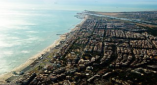
Ostia is a large neighbourhood in the Municipio X of the comune of Rome, Italy, near the ancient port of Rome, which is now a major archaeological site known as Ostia Antica. Ostia is also the only municipio or district of Rome on the Tyrrhenian Sea, and many Romans spend the summer holidays there. It is entirely situated within the municipality of Rome and is the city's seaside resort.

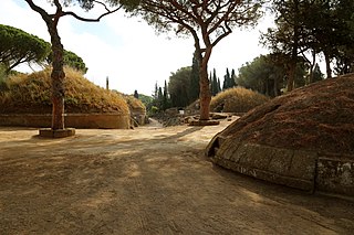
The Isola Sacra Necropolis or Necropolis of Portus in the Isola Sacra was the first large-scale pagan cemetery of Roman Imperial times to be excavated. The excavator-in-chief of most of Isola Sacra was Guido Calza. The necropolis was found on the manmade island of Isola Sacra, which lies between the cities of Portus and Ostia Antica, a region just south of Rome. The emperor Trajan was in power when this artificial island was created. Much of the excavated necropolis flanked the Via Severiana, which ran through Isola Sacra and traveled southeast from Ostica to Terracina.

Ponte Galeria is the 41st zona of Rome, Italy, identified by the initials Z. XLI. Geographically it was part of Agro Romano. The zone belongs to the Municipio XI.
Ficana was an ancient city of Latium, which figures in Roman history only on the occasion of its conquest by Ancus Marcius, who is said to have moved the inhabitants to Rome, and destroyed the city itself. It is certain that it was never repeopled: its name is found in Pliny's list of the extinct cities of Latium, and is noticed also by Festus as a place no longer in existence. The latter passage, however, affords us a clue to its position; according to Marcus Antistius Labeo there cited, it was situated on the Via Ostiensis, eleven miles from Rome, and apparently immediately adjoining the Tiber, on which it had a port, at a place called by Fabius Pictor the Puilia Saxa. The city's site is in the commune of Rome near Acilia, on the via Ostiense between Rome and Ostia.
Fregenae was a maritime town of ancient Etruria, situated between Alsium and the mouth of the Tiber. The modern Fregene is an Italian hamlet (frazione) of Fiumicino, in the Metropolitan City of Rome Capital, Lazio. As of 2012 its population was of 6,445.

Raissa Samojlovna Calza was a Ukrainian dancer who became a prominent classical archaeologist of Roman portraiture. When she was young, she fled to Italy and France following the Russian Revolution.

Maria Floriani Squarciapino (1917-2003) was an Italian classical archaeologist and professor at La Sapienza University in Rome, known for her work on the Roman port city of Ostia.

The zones of Rome are toponymic subdivisions within the area of the Ager Romanus, belonging to the Municipalities of Rome and Fiumicino, Italy.

The Litorale Romano state nature reserve is a protected area in Lazio (Italy), established by the Ministry of the Environment with Ministerial Decree of March 29, 1996, which includes a large territory of historical-naturalistic interest within the municipalities of Rome and Fiumicino at Tiber Valley.
With its over 17,000 hectares, discontinuously distributed along the Lazio coast between Palidoro and Capocotta, it is the largest protected area overlooking the Mediterranean Sea. Its management is entrusted to the two municipalities in their respective sections of competence.
The Marina of Rome is a tourist port that rises along the banks of Ostia, in the Municipality of Rome (Italy).

Tor San Michele, also known as Forte San Michele, is a coastal watchtower in Ostia, a frazione of the Municipality of Rome (Italy), rising near the mouth of the Tiber.

