Itu'ti'u

Last updated
Map showing districts of Rotuma RotumaMap.png
Map showing districts of Rotuma

Itu'ti'u is one of the seven districts on the island of Rotuma, a dependency of Fiji. Rotuma's capital, the village of Ahau, is located in this district. It also includes the villages of Savlei, Lau, Feavai, Tuakoi, Motusa, Ropure, Melsa'a, and Losa. [1]

Rotuma Island dependency of Fiji

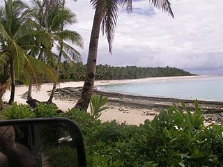
Rotuma is a Fijian dependency, consisting of Rotuma Island and nearby islets. The island group is home to a large and unique indigenous ethnic group which constitutes a recognisable minority within the population of Fiji, known as "Rotumans". Its population at the 2007 census was 2,002, although many more Rotumans live on mainland Fijian islands, totaling 10,000.

A dependent territory, dependent area or dependency is a territory that does not possess full political independence or sovereignty as a sovereign state yet remains politically outside the controlling state's integral area.

Fiji Country in Oceania

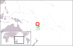
Fiji, officially the Republic of Fiji, is an island country in Melanesia, part of Oceania in the South Pacific Ocean about 1,100 nautical miles northeast of New Zealand's North Island. Its closest neighbours are Vanuatu to the west, New Caledonia to the southwest, New Zealand's Kermadec Islands to the southeast, Tonga to the east, the Samoas and France's Wallis and Futuna to the northeast, and Tuvalu to the north. Fiji consists of an archipelago of more than 330 islands—of which 110 are permanently inhabited—and more than 500 islets, amounting to a total land area of about 18,300 square kilometres (7,100 sq mi). The most outlying island is Ono-i-Lau. The two major islands, Viti Levu and Vanua Levu, account for 87% of the total population of 898,760. The capital, Suva, on Viti Levu, serves as the country's principal cruise-ship port. About three-quarters of Fijians live on Viti Levu's coasts, either in Suva or in smaller urban centres such as Nadi—where tourism is the major local industry—or Lautoka, where the sugar-cane industry is paramount. Due to its terrain, the interior of Viti Levu is sparsely inhabited.

Itu'ti'u is the largest district by area and by population. Its name means "Big District" in the Rotuman language, and is traditionally ranked third in terms of chiefly precedence, determined by consumption order in the politically charged kava ceremony. This was determined by its successful allegiance in the Rotuman Religious Wars between the Roman Catholic districts of Juju and Pepjei, (collectively referred to as Faguta), against the predominantly Wesleyan districts alliance, led by the chiefs of Noa'tau, Oinafa, Malha'a, Itu'muta and Itu'tiu.

Rotuman, also referred to as Rotunan, Rutuman or Fäeag Rotuma, is an Austronesian language spoken by the indigenous people of the South Pacific island group of Rotuma, an island with a Polynesian-influenced culture that was incorporated as a dependency into the Colony of Fiji in 1881. Classification of Rotuman is difficult due to the large number of loan words from Samoan and Tongan, as a result of much cultural exchange over the history of the Pacific. Linguist Andrew Pawley groups the language with the West Fijian languages in a West Fijian – Rotuman branch of the Central Pacific sub-group of Oceanic languages.

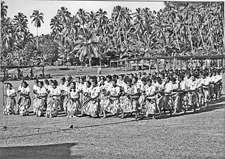
Kava cultures are the religious and cultural traditions of western Oceania which consume kava. There are similarities in the use of kava between the different cultures, but each one also has its own traditions.

Juju (district)

Juju is one of the seven districts on the island of Rotuma, a dependency of Fiji. It includes the villages of Juju, Toai, and Haga.

Mofmanu Beach, the popular main beach adjacent to the village of Motusa Mofmanu beach in Motusa, Rotuma.jpg
Mofmanu Beach, the popular main beach adjacent to the village of Motusa

Related Research Articles

Elections in Fiji

Fiji has held 10 general elections for the House of Representatives since becoming independent of the United Kingdom in 1970; there had been numerous elections under colonial rule, but only one with universal suffrage. In this period, Fiji has had three constitutions, and the voting system has changed accordingly. Note that there are no general elections for the Senate: The 32 Senators are nominated, not elected.

The Council of Rotuma is a municipal body on the island of Rotuma, a Fijian dependency. Owing to the unique character of Rotuma, the powers of this council are greater than those of other municipal bodies in Fiji and in some ways it approximates a legislative body, though it is in every way subordinate to the Parliament of Fiji.

Solkope is a small and densely wooded island off the southern coast of Rotuma in the Fiji Islands, at the edge of the fringing coral reef. It is separated from the main island of Rotuma by a channel that is between 50 and 200 m wide, and lies immediately southeast of the village of Kalvaka in the district of Noa'tau. It 765 m long east-west, and up to 515 m wide, and rises to a height of 128 m. Its area is 0.3 km². From the sea, it cannot be recognised as a separate island.

The Rotuma Group is a group of volcanic islands with Rotuma Island being the main island, located at 12°35′S177°10′E, approximately 465 km north of Fiji.

Rotuma (Rotuman Communal Constituency, Fiji) Rotuman communal constituency of Fiji

Rotuma Communal is a former electoral division of Fiji, the sole communal constituency reserved for citizens of Rotuman descent. Established by the 1997 Constitution, it came into being in 1999 and was used for the parliamentary elections of 1999, 2001, and 2006. Its boundaries encompassed the entire nation; Rotuman-descendants anywhere in Fiji were eligible to vote for, and be a candidate for, this constituency..

Motusa group of villages in Rotuma, Fiji

Motusa is a group of close villages in the district of Itu'tiu, on the island of Rotuma, one of the islands of Fiji. Rotuma is made up of two volcanic landmasses connected by a sandy isthmus, on which Motusa is located.

Dance in Rotuma

Dance in Rotuma refers to the traditional and modern dance styles performed by the people of the island of Rotuma, which became a dependency of Fiji in 1881. Despite Rotuma's political and historical links with Fiji, the island's culture shows strong Polynesian influences, particularly from Samoa and Tonga, which, along with Fiji, feature strongly in the history and traditions of the Rotuman people.

Dr John Charles Fatiaki is a career medical practitioner who was chosen by the Rotuma Island Council to be their representative in the Fijian Senate.

Sau,, refers to the role of spiritual leader in pre-Christian Rotuman society. The title was neither primogenitary nor held for a lifetime, but rather was cycled through the chiefs of each of Rotuma’s districts.

Gagaja[ŋaŋatʃa] is a Rotuman word denoting the position of "Chief" or "Lord". This could be a formal chiefly position in one of the seven districts or a village chief as well as to anyone else, such as the Chairman of the Rotuma Island Council to whom respect and deference is owed based on their own skills and attributes. Unlike in many other Pacific cultures, the official chiefly positions are not allocated according to any strict primogeniture, but rather are elected from all eligible males within certain kạinaga to whom the chiefly title belongs.

The Fakpure was the secular ruler of Rotuma in the pre-European contact times. It was one of three chiefly roles with direct influence across the island of Rotuma, the other two being the Mua and the Sau. Traditionally the most senior political authority on the island, the Fakpure was one of the gagaj ‘es itu’u of the districts of Rotuma, and the convener of the island’s Council of Chiefs. After being elected as the district chief through the traditional processes, the position of fakpure was bestowed on the most senior of these district chiefs, usually the chief whose district had won the most recent war, who also received the privilege of being the first served in the politically charged kava ceremony.

Noa’tau

Noa'tau is one of the seven districts on the island of Rotuma, a dependency of Fiji. It includes the villages of Maragteu and Fekeoko.

Colonel Paul Manueli is a former Commander of the Royal Fiji Military Forces, a former Fiji Cabinet minister, Senator and successful businessman.

The Rotumans are the indigenous inhabitants of Rotuma, a small island group forming part of the Republic of Fiji. The island itself is a cultural melting pot at the crossroads of the Micronesian, Melanesian and Polynesian divisions of the Pacific Ocean, and due to the seafaring nature of traditional Pacific cultures, the indigenous Rotuman have adopted or share many aspects of its multifaceted culture with its Melanesian, Micronesian and Polynesian neighbours.

Fiji has three official languages under the 1997 constitution : English, Fijian and Hindi. Fijian is spoken either as a first or second language by most indigenous Fijians who make up around 54% of the population.

Vilsoni Hereniko is a Fiji Islander playwright, film director and academic. He was the writer and director of Fiji's first ever feature film, The Land Has Eyes.

Hatana Island is considered the most sacred or "ha'a" islet of the Rotuma Group, Fiji, commonly featuring in various Rotuman Creation myths.

Itumuta

Itu'muta is one of the seven districts on the island of Rotuma, a dependency of Fiji. It includes the villages of Maftoa and Lopo.

References

  1. "Itu'ti'u". Rotuma.net. Retrieved 10 June 2010.

Coordinates: 12°30′31″S177°02′21″E / 12.50861°S 177.03917°E / -12.50861; 177.03917

Geographic coordinate system Coordinate system

A geographic coordinate system is a coordinate system that enables every location on Earth to be specified by a set of numbers, letters or symbols. The coordinates are often chosen such that one of the numbers represents a vertical position and two or three of the numbers represent a horizontal position; alternatively, a geographic position may be expressed in a combined three-dimensional Cartesian vector. A common choice of coordinates is latitude, longitude and elevation. To specify a location on a plane requires a map projection.