
The Juruá River is a southern affluent river of the Amazon River west of the Purus River, sharing with this the bottom of the immense inland Amazon depression, and having all the characteristics of the Purus as regards curvature, sluggishness and general features of the low, half-flooded forest country it traverses.

The Javary River, Javari River or Yavarí River is a 1,184 km (736 mi) tributary of the Amazon that forms the boundary between Brazil and Peru for more than 500 km (310 mi). It is navigable by canoe for 900 km (560 mi) from above its mouth to its source in the Ucayali highlands, but only 260 were found suitable for steam navigation.

The Purus River is a tributary of the Amazon River in South America. Its drainage basin is 371,042 km2 (143,260 sq mi), and the mean annual discharge is 11,207 m3/s (395,800 cu ft/s). The river shares its name with the Alto Purús National Park and the Purús Province, one of the four provinces of Peru in the Ucayali Region.

The Rio Negro, or Guainía as it is known in its upper part, is the largest left tributary of the Amazon River, the largest blackwater river in the world, and one of the world's ten largest rivers by average discharge. Despite its high flow, the Rio Negro has a low sediment load.

Guarapari is a coastal town of Espírito Santo, Brazil, a popular tourist destination. Its beach is famous for the high natural radioactivity level of its sand.

Iporanga is a municipality in the state of São Paulo in Brazil. The population is 4,199 in an area of 1152 km2. The elevation is 81 m.

Conceição da Barra is a Brazilian municipality in the state of Espírito Santo. The city is the northernmost coastal city of the state. Its population was 31,273 (2020) and its area is 1,188.044 km².

The Japurá River or Caquetá River is a 2,820 kilometres (1,750 mi) long river in the Amazon basin. It rises in Colombia and flows eastward through Brazil to join the Amazon River.

The Juruena River is a 1,240 km (770 mi) long river in west-central Brazil, in the state of Mato Grosso.

Aripuanã River is a river in the Mato Grosso and Amazonas states in north-western Brazil. It is a tributary of the Madeira River in the Amazon Basin. The town of Novo Aripuanã is located on its banks where it merges into the Madeira River. The town of Aripuanã is also on its banks, but on the upper (southern) section of the river.

The Ituí River is a river of the upper Amazon Basin. It traverses some 370 km of the Atalaia do Norte municipality in the Amazonas state of north-western Brazil. The Ituí is a left tributary of the Javary River. It drains a very low gradient, dropping hardly 100 m over its whole extent, which results in extensive meandering. The Rio Negro, Beija-flor and Branquinho are some of its western tributaries, while the Rio Novo is its main eastern tributary. Downstream it joins the Itaquai River to form the upper Solimões.

The Jutaí River is a river in Amazonas state in north-western Brazil.

The Tapauá River is a river of Amazonas state in north-western Brazil. It is a left tributary of the Purus River.
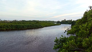
The Itaúnas River is a river of Espírito Santo state in eastern Brazil.
The Maicuru Biological Reserve, is a strictly protected biological reserve in the state of Pará, Brazil. It covers 11,518 square kilometres (4,447 sq mi) of Amazon rainforest.
Rio Negro State Park South Section is a State park in the state of Amazonas, Brazil. It protects an area of Amazon rainforest to the east of the Rio Negro that is home to the endangered pied tamarin. The area was reduced in 2001 and was further reduced in 2014 to create a sustainable development reserve for the people that had been living there since before the park was created.

The Serra do Conduru State Park is a state park in the state of Bahia, Brazil. It protects an area of Atlantic Forest that is regenerating after damage from human intervention.
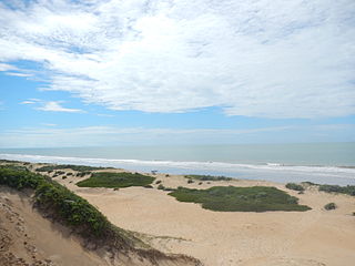
The Itaúnas State Park is a state park in the state of Espírito Santo, Brazil. It protects the lower reaches of the Itaúnas River and a strip of marshes, dunes and beaches along the Atlantic coast of the north of the state.

The Delta do Parnaíba Environmental Protection Area is a federally-administered environmental protection area that covers parts of the coasts of the states of Maranhão, Piauí and Ceará, Brazil.
