Franconia is a region of Germany, characterised by its culture and East Franconian dialect. Franconia is made up of the three Regierungsbezirke of Lower, Middle and Upper Franconia in Bavaria, the adjacent, Franconian-speaking South Thuringia, south of the Thuringian Forest—which constitutes the language boundary between Franconian and Thuringian—and the eastern parts of Heilbronn-Franconia in Baden-Württemberg.
Coburg is a Landkreis (district) in Bavaria, Germany. It is bounded by the districts of Kronach, Lichtenfels, Bamberg and Haßberge, and by the state of Thuringia. The district surrounds, but does not include the city of Coburg.
Kronach is a Landkreis (district) in Bavaria, Germany. It is bounded by the districts of Hof, Kulmbach, Lichtenfels and Coburg, and the state of Thuringia.
The Duchy of Bavaria was a frontier region in the southeastern part of the Merovingian kingdom from the sixth through the eighth century. It was settled by Bavarian tribes and ruled by dukes (duces) under Frankish overlordship. A new duchy was created from this area during the decline of the Carolingian Empire in the late ninth century. It became one of the stem duchies of the East Frankish realm, which evolved as the Kingdom of Germany and the Holy Roman Empire.

Coburg is a town located on the Itz river in the Upper Franconia region of Bavaria, Germany. Long part of one of the Thuringian states of the Wettin line, it joined Bavaria by popular vote only in 1920. Until the revolution of 1918, it was one of the capitals of the Duchy of Saxe-Coburg and Gotha and the Duchy of Saxe-Coburg-Saalfeld.
Rodach may refer to several locations in southern Germany:

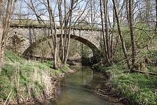
The Breitengüßbach–Dietersdorf railway was a single-tracked branch line in the province of Upper Franconia in Bavaria, southern Germany. It branched off from the main line from Bamberg to Hof, northeast of Breitengüßbach station, only a few hundred yards after the branch line to Ebern–Maroldsweisach, and headed north into the lower reaches of the Itz valley. The line was taken into service on 1 October 1913.

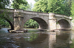
The Itz Valley Railway was a former, 8 kilometre long branch line in Bavaria, Germany, running from Creidlitz, in the borough of Coburg, to Rossach in the municipality of Großheirath.
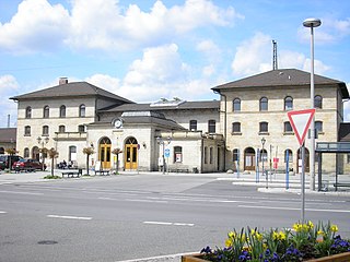
Lichtenfels station is in the town of Lichtenfels in Upper Franconia in the German state of Bavaria. It is a regional rail hub and a former ICE stop on the Hamburg–Berlin Munich route and is classified by Deutsche Bahn as a station of category 3.

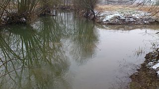
Effelder is a 17 km (11 mi) tributary river of the Itz in the districts of Sonneberg (Thuringia) and Coburg (Bavaria). It flows into the Froschgrundsee, which is drained by the Itz, near Schönstädt.
Röthen is a river of Thuringia and Bavaria, Germany. It passes through Sonneberg and Neustadt bei Coburg, and flows into the Itz near Rödental.
The Streu is a river of Thuringia and Bavaria, Germany.
The Alster is a river of Bavaria and of Thuringia, Germany. It is a right-bank tributary of the Itz, which it joins near Kaltenbrunn.

Steinach is a river of Thuringia and Bavaria, Germany. Its source is near Neuhaus am Rennweg, and it flows to the south, passing through the towns Steinach and Sonneberg. It is a right tributary of the Rodach, which it joins near Redwitz an der Rodach. It is a popular hiking area for locals, as well.

Lauter is a river of Bavaria, Germany. It is a right tributary of the Itz in Coburg.

Rodach is a river of Bavaria and of Thuringia, Germany. It is a left tributary of the Itz near Itzgrund. It passes through Bad Rodach.

Tannbach is a brook that is 8.7 kilometres (5.4 mi) long in north-east Bavaria and southern Thuringia, Germany.

The Heldburger Land was the historical, Saxon, administrative district (Amtsbezirk) of Heldburg and is today the southernmost part of the Free State of Thuringia and the district of Hildburghausen, between the towns of Coburg, Hildburghausen and Bad Königshofen. The region known now as the Heldburger Land is referred to administratively as the Heldburger Unterland, and sometimes in the vernacular as the Heldburger Zipfel.
The Lange Berge are a small range of the German Central Uplands, up to 527.2 m above sea level (NN), which lie mainly in the Bavarian provinces of Upper Franconia with northwestern foothills in Thuringia.

Franconia is a region that is not precisely defined, but which lies in the north of the Free State of Bavaria, parts of Baden-Württemberg and South Thuringia and Hesse in Germany. It is characterised by its own cultural and linguistic heritage. Its history began with the first recorded human settlement about 600,000 years ago. Thuringii, Alemanni and Franks, who gave the region its name, settled the area in the Early Middle Ages. From the mid-9th century, the Stem Duchy of Franconia emerged as one of the five stem duchies of the Empire of East Francia. On 2 July 1500, during the reign of Emperor Maximilian I, as part of the Imperial Reform, the empire was divided into Imperial Circles. The Franconian Circle, which was formed as a result of this restructuring, became decisive in the creation of a Franconian national identity. A feature of Franconia in the Middle Ages and Early Modern Period was its Kleinstaaterei, an extreme fragmentation into little states and territories. In the 19th century under Napoleon, large parts of Franconia were incorporated into the newly created Kingdom of Bavaria.