Related Research Articles
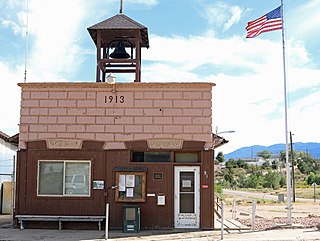
Rockvale is a statutory town in Fremont County, Colorado, United States. The population was 511 at the 2020 census.
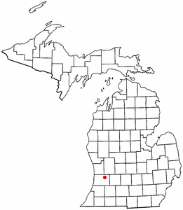
Hopkins Township is a civil township of Allegan County in the U.S. state of Michigan. The population was 2,760 at the 2020 census. The township is named after Stephen Hopkins, a signer of the Declaration of Independence.
The Esk'etemc First Nation, also known as the Alkali Lake Indian Band, is a First Nations government of the Secwepemc (Shuswap) people, located at Alkali Lake in the Cariboo region of the Central Interior of the Canadian province of British Columbia. It was created when the government of the then-Colony of British Columbia established an Indian reserve system in the 1860s. It is one of three Secwepemc bands that is not a member of either the Shuswap Nation Tribal Council or the Northern Shuswap Tribal Council.
The Kluskus First Nation is the band government of the Lhoosk’uz, a Dakelh people whose main reserve located on the Chilcotin Plateau 130 km west of the city of Quesnel, British Columbia, Canada. The First Nation is a member of the Carrier-Chilcotin Tribal Council, which includes both Tsilhqot'in and Carrier (Dakelh) communities.
The Tlʼetinqox-tʼin Government Office is a First Nations government located in the Chilcotin District in the western Central Interior region of the Canadian province of British Columbia. Governing a reserve communities near Alexis Creek known as Anaham Reserve First Nations or Anaham, it is a member of the Tsilhqotʼin Tribal Council aka known as the Tsilhqotʼin National Government. The main reserve is officially known as Anahim's Flat No. 1, and is more commonly as Anaham. Other reserves are Anahim's Meadow No. 2 and 2A, and Anahim Indian Reserves Nos. 3 through 18. Anaham, or Anahim and Alexis were chiefs of the Tsilhqotʼin during the Chilcotin War of 1864, although they and their people did not take part in the hostilities.
Horneline Creek Provincial Park is a provincial park in far northern British Columbia, Canada. It is located west of the Kechika River about 130 km south of Lower Post and 30 km north of Denetiah Provincial Park and southwest of the community of Liard River.
Parallel Creek is a creek in northern British Columbia, Canada. It flows northwest into an expansion of the Jennings River.
The Smith River is a river in the Yukon Territory and the province of British Columbia, Canada, arising in the Yukon at 60°09′N126°18′W and crossing the border to enter British Columbia at 60°00′00″N126°23′25″W to its confluence with the Liard River at 59°33′00″N126°29′00″W, between the confluences of the Toad and Coal Rivers. At the confluence is the site of the former Hudson's Bay Company trading post, Fort Halkett, and also Smith River Falls, which are jointly protected by Smith River Falls-Fort Halkett Provincial Park.
Highland is an unincorporated community in Pulaski County, in the U.S. state of Virginia.
Paddock is an unincorporated community in Holt County, Nebraska, United States.
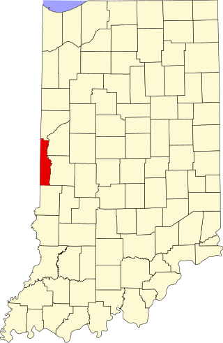
Needmore is an unincorporated community in Clinton Township, Vermillion County, in the U.S. state of Indiana.
Scott is an unincorporated community in Cole County, in the U.S. state of Missouri. The community is located on Grays Creek just northwest of Jefferson City.
Dyke Branch is a stream in Johnson County, Kansas and Jackson County, Missouri. It is a tributary of Indian Creek. The headwaters are in eastern Kansas at 38°59′22″N94°37′08″W and the confluence with Indian Creek is in Missouri at 38°57′08″N94°34′40″W.
Mosby Creek is a stream in southeastern Pettis County in the U.S. state of Missouri. It is a tributary to Anderson Branch which is in turn a tributary of Walnut Creek. Sedalia is approximately nine miles to the north.
King Branch is a stream in western Polk County in the U.S. state of Missouri. It is a tributary of Turkey Creek.
Pleasant Valley, is a valley in two counties in two states adjacent states, White Pine County, Nevada and Juab County, Utah. Its mouth is located at an elevation of 5,682 feet in Utah. Its head is at 39°44′09″N114°09′53″W at an elevation of 6,965 feet in Nevada. It lies between the Kern Mountains on the south, and South Mountains to the northwest and the Deep Creek Range on the north.
Raysville is an unincorporated community in McDuffie County, in the U.S. state of Georgia. The community is on a peninsula jutting into Lake Strom Thurmond between Big Creek and Germany Creek arms of the lake. Georgia Route 43 passes through the community.
Mess Creek, formerly known as Mestua, is a tributary of the Stikine River in northwestern British Columbia, Canada. It flows north and northwest for about 110 km (68 mi), through a lake and a gorge to join the Stikine River, which in turn flows southwest across the Canada–United States border into Alaska where it empties into various straits of the Inside Passage. The northern half of Mess Creek forms a western boundary of Mount Edziza Provincial Park which lies within the traditional territory of the Tahltan people.