
Robbers Cave State Park is a state park in Latimer County, Oklahoma. It is located 5 miles (8.0 km) north of Wilburton, Oklahoma, on State Highway 2. Originally named Latimer State Park, it received its current name in 1936. It is located in the scenic, hilly woodlands of the Sans Bois Mountains of southeast Oklahoma. This park is a favorite of rappellers, equestrians, hikers and outdoor lovers. The park and adjoining wildlife management area covers more than 8,000 acres (3,200 ha) and includes three lakes. It offers visitors acres of discovery and enjoyment including trout fishing in season, boating, hunting, mountain biking, trails for hikers and horses, sandstone cliffs for climbing and rappelling, and fall foliage viewing. In addition, Robbers Cave is historically notable as a former hideout for infamous outlaws Belle Starr and Jesse James.

McCarren Park is a public park in Brooklyn, New York City. It is located on the border of Williamsburg and Greenpoint and is bordered by Nassau Avenue, Bayard Street, Lorimer Street and North 12th Street. The park contains facilities for recreational softball, volleyball, soccer, handball, and other games. It is also used for sunbathing and dog-walking. It also includes the McCarren Play Center, which consists of a recreation center and a pool. McCarren Park is maintained by the New York City Department of Parks and Recreation.

Scenic State Park is a Minnesota state park near Bigfork in Itasca County. It encompasses 3,936 acres (1,593 ha) of virgin pine forests that surround Sandwick Lake and Coon Lake. It also includes portions of Lake of the Isles, Tell Lake, Cedar Lake, and Pine Lake. Established in 1921, the Ojibwe tribe had previously used the area for hunting. The park has places for camping, hiking, swimming, fishing, and canoeing.

J.W. Wells State Park is a state park in the U.S. state of Michigan. The 678-acre (2.74 km2) park is located in Menominee County on the shore of Lake Michigan's Green Bay, just south of Cedar River. It is on M-35, roughly midway between Menominee and Escanaba. It was added to the National Register of Historic Places in 2002.
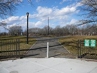
Red Hook Recreation Area, also known as Red Hook Park, is a 58.5-acre (237,000 m2) public park in the Red Hook neighborhood of Brooklyn, New York City, composed of several segments centered around Bay Street. The park's recreational facilities include handball courts, softball fields, a soccer and football field, and a running track. The Sol Goldman Play Center, within the block bounded by Bay, Henry, Lorraine and Clinton Streets, consists of a brick bathhouse and two pools. The park is operated by the New York City Department of Parks and Recreation, also known as NYC Parks.
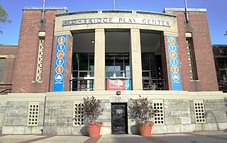
Highbridge Park is a public park on the western bank of the Harlem River in Washington Heights, Manhattan, New York City. It stretches between 155th Street and Dyckman Street in Upper Manhattan. The park is operated by the New York City Department of Parks and Recreation. The City maintains the southern half of the park, while the northern half is maintained by the non-profit New York Restoration Project. Prominent in the park are the Manhattan end of the High Bridge, the High Bridge Water Tower, and the Highbridge Play Center.
Astoria Park is a 59.96-acre (24.26 ha) public park in the Astoria neighborhood of Queens in New York City. The park is situated on the eastern shore of the Hell Gate, a strait of the East River, between Ditmars Boulevard to the north and Hoyt Avenue to the south. The Robert F. Kennedy (Triborough) and Hell Gate Bridges respectively pass over the park's southern and northern sections. Astoria Park contains a playground, a soccer field, a running track, a skate park, and courts for tennis, basketball, and bocce. Astoria Park also includes the Astoria Play Center, which consists of a recreation center and a pool. The park and play center are maintained by the New York City Department of Parks and Recreation.

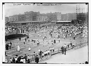
Jacob Riis Park, also called Jacob A. Riis Park and Riis Park, is a seaside park on the southwestern portion of the Rockaway Peninsula in the New York City borough of Queens. It lies at the foot of the Marine Parkway–Gil Hodges Memorial Bridge, east of Fort Tilden, and west of Neponsit and Rockaway Beach. Originally run by the New York City Department of Parks and Recreation, it later became part of the Jamaica Bay Unit of the Gateway National Recreation Area, and is managed by the National Park Service (NPS). It features an extensive sand beach along the Atlantic Ocean coastline and several historic Art Deco structures.

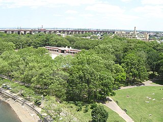
Crotona Park is a public park in the South Bronx in New York City, covering 127.5 acres (51.6 ha). The park is bounded by streets of the same name on its northern, eastern, southern, and western borders, and is adjacent to the Crotona Park East and Morrisania neighborhoods of the Bronx. It is divided into four portions by Claremont Parkway and Crotona Avenue, which run through it.

Backbone State Park is Iowa's oldest state park, dedicated in 1919. Located in the valley of the Maquoketa River, it is approximately three miles (5 km) south of Strawberry Point in Delaware County. It is named for a narrow and steep ridge of bedrock carved by a loop of the Maquoketa River originally known as the Devil's Backbone. The initial 1,200 acres (490 ha) were donated by E.M. Carr of Lamont, Iowa. Backbone Lake Dam, a relatively low dam built by the Civilian Conservation Corps (CCC) in the 1930s, created Backbone Lake. The CCC constructed a majority of trails and buildings which make up the park.

Portage Park is a 36-acre (15 ha) park in the Portage Park community area of Chicago, Illinois on the National Register of Historic Places. The park stretches from Irving Park Road on the south to Berteau Avenue between Central and Long Avenues. The largest public park on Chicago's Northwest Side, it has many recreational facilities including six tennis courts, two playgrounds, a slab for in-line skating, a bike path, a nature walk, five baseball fields, two combination football/soccer fields and two fieldhouses— one housing a gymnasium and the other a cultural arts building. The park also has an Olympic-size pool featuring a large deck for sunning, misting sprays, as well as an interactive water play area with slide and diving boards in addition to a smaller heated pool. Plans are currently underway for the development of a new, 6,500-square-foot (600 m2) senior center at Portage Park.

Copper Falls State Park is a 3,068-acre (1,242 ha) state park in Wisconsin. The park contains a section of the Bad River and its tributary the Tylers Forks, which flow through a gorge and drop over several waterfalls. Old Copper Culture Indians and later European settlers mined copper in the area. The state park was created in 1929 and amenities were developed by the Civilian Conservation Corps and the Works Progress Administration. In 2005 the park was listed on the National Register of Historic Places as a site with 10 contributing properties.
Sacajawea State Park is a public recreation area and historical preserve in the city of Pasco, Washington, covering 267 acres (108 ha) at the confluence of the Snake and Columbia rivers where the Lewis and Clark Expedition camped on October 16, 1805. The state park bears the name of the Shoshone woman Sacagawea, who was an active member of the expedition married to expedition member Toussaint Charbonneau, a French-Canadian interpreter and explorer. The park's Sacajawea Interpretive Center features exhibits about her and about the Lewis and Clark Expedition.

Dells of the Eau Claire County Park is in the north-central Wisconsin Town of Plover, east of the city of Wausau. It is divided in two by the Eau Claire River. The river flows through a rocky gorge to form cascades and waterfalls as it passes over and around weathered boulders, outcrops, and other formations. The depth of the river can vary depending on the time of the year. The park also has areas designated for camping, swimming, hiking, and picnicking.

Lacey-Keosauqua State Park is located southwest of Keosauqua, Iowa, United States. The park is located along the Des Moines River in Van Buren County. First dedicated in 1921, it is the largest state park in size in Iowa. In 1990, three areas were named nationally recognized historic districts and listed on the National Register of Historic Places.

Jackie Robinson Park is a public park in the Hamilton Heights and Harlem neighborhoods of Manhattan in New York City. The approximately 12.77-acre (5.17 ha) park is bounded by Bradhurst Avenue to the east, 155th Street to the north, Edgecombe Avenue to the west, and 145th Street to the south. The park has baseball fields, basketball courts, restrooms, and a bandshell, which are arranged around the park's steep terrain. It also includes the Jackie Robinson Play Center, which consists of a recreation center and a pool. Jackie Robinson Park is maintained by the New York City Department of Parks and Recreation.

Sunset Park is a 24.5-acre (9.9 ha) public park in the neighborhood of Sunset Park, Brooklyn, New York City, between 41st and 44th Streets and 5th and 7th Avenues. The modern-day park contains a playground, recreation center, and pool. The recreation center and pool comprise the Sunset Play Center, which was designated as both an exterior and interior landmark by the New York City Landmarks Preservation Commission. The park is operated by the New York City Department of Parks and Recreation, also known as NYC Parks.

Betsy Head Park is a 10.55-acre (4.27 ha) public park in the Brownsville neighborhood of Brooklyn in New York City. The park occupies two non-contiguous plots diagonally across from each other at the intersection of Dumont Avenue and Thomas S. Boyland Street, covering a collective 10.55 acres (4.27 ha). The modern-day park contains a playground, a swimming complex, and fields for baseball, football, tennis, and basketball. The park's swimming complex, the Betsy Head Play Center, was designed by Ely Jacques Kahn and consists of a bathhouse, a general swimming pool, and an infilled diving pool. The park is operated by the New York City Department of Parks and Recreation, also known as NYC Parks.
Thomas Jefferson Park is a 15.52-acre (6.28 ha) public park in the East Harlem neighborhood of Manhattan in New York City. The park is on First Avenue between 111th and 114th Streets. It contains a playground as well as facilities for baseball, basketball, football, handball, running, skating, and soccer. The Thomas Jefferson Play Center within the park consists of a recreation center and a pool. The park and play center, named for former U.S. president Thomas Jefferson, are maintained by the New York City Department of Parks and Recreation.

Prentis Park is a city park in Vermillion, South Dakota. It is a rectangular 20-acre (8.1 ha) park located on the block bounded by Plum Street, Main Street, Clark Street, and Prentis Avenue. It was listed on the National Register of Historic Places in 2001.
