Iván Martínez Airport

Last updated
Iván Martínez Airport
Summary
Airport type Private
Serves Isla Tierra del Fuego
Elevation  AMSL 144 ft / 44 m
Coordinates 52°58′05″S70°01′00″W / 52.96806°S 70.01667°W / -52.96806; -70.01667 (Iván Martínez Airport (Isla Tierra del Fuego)) Coordinates: 52°58′05″S70°01′00″W / 52.96806°S 70.01667°W / -52.96806; -70.01667 (Iván Martínez Airport (Isla Tierra del Fuego))
Map
Chile location map.svg
Airplane silhouette.svg
SCIT
Location of Iván Martínez Airport in Chile
Runways
Direction Length Surface
m ft
08/26 605 1,985 Gravel
Source: GCM [1] Bing Maps [2]

Iván Martínez Airport( ICAO : SCIT) is an airstrip serving the settlement of Estancia, 62 kilometres (39 mi) east-northeast of Punta Arenas in the Magallanes y Antártica Chilena Region of Chile. The airstrip is on the main island of Tierra del Fuego, 6 kilometres (3.7 mi) inland from the Gente Grande Bay (sv) off the Strait of Magellan.

ICAO airport code four-letter code designating many airports around the world

The ICAOairport code or location indicator is a four-letter code designating aerodromes around the world. These codes, as defined by the International Civil Aviation Organization and published in ICAO Document 7910: Location Indicators, are used by air traffic control and airline operations such as flight planning.
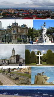
Punta Arenas Place in Magallanes y Antártica Chilena, Chile

Punta Arenas is the capital city of Chile's southernmost region, Magallanes and Antartica Chilena. The city was officially renamed as Magallanes in 1927, but in 1938 it was changed back to "Punta Arenas". It is the largest city south of the 46th parallel south, and at the same time the most populous southernmost city in Chile and in the Americas, and due its location, the coldest coastal city with more than 100,000 inhabitants in Latin America. It is also one of the most populous sites so to the south of the world.

Chile Republic in South America

Chile, officially the Republic of Chile, is a South American country occupying a long, narrow strip of land between the Andes to the east and the Pacific Ocean to the west. It borders Peru to the north, Bolivia to the northeast, Argentina to the east, and the Drake Passage in the far south. Chilean territory includes the Pacific islands of Juan Fernández, Salas y Gómez, Desventuradas, and Easter Island in Oceania. Chile also claims about 1,250,000 square kilometres (480,000 sq mi) of Antarctica, although all claims are suspended under the Antarctic Treaty.

Contents

The Punta Arenas VOR-DME (Ident: NAS) is 29.8 nautical miles (55.2 km) west of the airstrip. [3]

See also

Transport in Chile

Transport in Chile is mostly by road. The south of the country is not connected to central Chile by road, except through Argentina, and water transport also plays a part there. The railways were historically important in Chile, but now play a relatively small part in the country's transport system. Because of the country's geography and long distances between major cities, aviation is also important.

Related Research Articles

Atacalco Airport Spanish: Aeropuerto Atacalco, is a rural airstrip 10 kilometres (6.2 mi) southeast of Recinto (es), a community in the Bío Bío Region of Chile.

Santa Rita Airport is an airstrip 6 kilometres (3.7 mi) northwest of Casablanca, a city in the Valparaíso Region of Chile.

Yendegaia Airport Spanish: Aeropuerto Yendegaia, is a rural airstrip in the Magallanes Region of Chile. The nearest town is Ushuaia, 32 kilometres (20 mi) to the east in Argentina.

Vodudahue Airport Spanish: Aeropuerto Vodudahue, is an airstrip 56 kilometres (35 mi) northeast of Chaitén, a town in the Los Lagos Region of Chile. The airstrip is in the valley of the Vodudahue River, 5 kilometres (3.1 mi) east of where the river empties into the Comau Fjord. The valley extends eastward into Pumalín Park.

For the airport in Mexico see Francisco Sarabia International Airport

La Obra Airport Spanish: Aeropuerto La Obra, is an airstrip serving Cumpeo, a small town in the Río Claro commune of the Maule Region in Chile. The airstrip is 6 kilometres (3.7 mi) southwest of the town.

La Montaña Airport Spanish: Aeropuerto de La Montaña, is an airstrip 27 kilometres (17 mi) east of Curicó, a city in the Maule Region of Chile.

Fundo Tehuén Airport, is an airstrip 6.8 kilometres (4.2 mi) northwest of Frutillar, a town in the Los Lagos Region of Chile.

Punta el Saco Airport Spanish: Aeropuerto Punta el Saco, is an airport on the south shore of Isla Mocha, a small Pacific island 32 kilometres (20 mi) off the coast of Chile. Isla Mocha is part of Chile's Bío Bío Region.

Punta Galera Airport Spanish: Aeropuerto Punta Galera, is an airstrip located 62 kilometres (39 mi) west-northwest of La Unión, a city in the Los Lagos Region of Chile.

Los Alerces Airport is an airstrip 16 kilometres (9.9 mi) north-northeast of Chaitén, a coastal city in the Los Lagos Region of Chile. The airstrip is in an open mountain valley 6 kilometres (3.7 mi) north of the Chaitén volcano caldera.

Hacienda Lipangue Airport Spanish: Aeropuerto de Hacienda Lipangue, is an airstrip 6 kilometres (3.7 mi) southwest of Lampa, a city in the Santiago Metropolitan Region of Chile.

Huayanay Airport, is an airstrip 36 kilometres (22 mi) northwest of Ovalle, a city in the Coquimbo Region of Chile.

Los Monos Airport, is an airstrip 15 kilometres (9.3 mi) southwest of Molina, a city in the Maule Region of Chile.

Sandra Scabini Airport, was an airstrip 115 kilometres (71 mi) northeast of Punta Arenas, the capital of the Magallanes Region of Chile.

Punta Baja Airport is an airstrip on the shore of General Carrera Lake in the Aysén Region of Chile. The nearest village is Puerto Guadal (es) 8 kilometres (5.0 mi) away on the other side of the lake.

La Capilla Airport, is an airstrip 15 kilometres (9.3 mi) west-northwest of Entre Lagos, a town in the Los Lagos Region of Chile.

Santa Marta Airport is an airstrip 10 kilometres (6 mi) southeast of San Carlos, a town in the Bío Bío Region of Chile.

Viñamar Airport Spanish: Aeropuerto Viñamar, is an airstrip serving the Viñamar winery southeast of Casablanca, a city in the Valparaíso Region of Chile.

Punta San Juan Airport airport in El Salvador

Punta San Juan Airport is an airport serving the village of Corral De Mulas in Usulután Department, El Salvador. The unmarked grass runway is 7 kilometres (4.3 mi) east of the village on Punta San Juan, the western shore of the entrance to Bahia de Jiquilisco. Corral de Mulas is also served by Corral de Mulas Airport.

References

The Aviation Safety Network (ASN) is a website that keeps track of aviation accidents, incidents, and hijackings. Their database contains details of over 10,700 reports. The ASN includes an aviation database with aviation investigations, news, photos, and statistics.