J.D. Ryan

Last updated

J.D. Ryan was a Montana rancher and pioneer mining operator in Joshua Tree National Park. The popular park destination Ryan Mountain is named after him. [1]

Montana State of the United States of America

Montana is a landlocked state in the Northwestern United States. Montana has several nicknames, although none are official, including "Big Sky Country" and "The Treasure State", and slogans that include "Land of the Shining Mountains" and more recently "The Last Best Place".

Joshua Tree National Park national park of the United States

Joshua Tree National Park is an American national park in southeastern California, east of Los Angeles, near San Bernardino and Palm Springs. The park is named for the Joshua trees native to the Mojave Desert. Originally declared a national monument in 1936, Joshua Tree was redesignated as a national park in 1994 when the U.S. Congress passed the California Desert Protection Act. Encompassing a total of 790,636 acres —an area slightly larger than the state of Rhode Island—the park includes 429,690 acres of designated wilderness. Straddling the border between San Bernardino County and Riverside County, the park includes parts of two deserts, each an ecosystem whose characteristics are determined primarily by elevation: the higher Mojave Desert and the lower Colorado Desert. The Little San Bernardino Mountains traverse the southwest edge of the park.

Ryan Mountain

Ryan Mountain is a 5,456-foot-high (1,663 m) mountain in Joshua Tree National Park. The trail to the peak is a strenuous hike, ascending 1,050 feet (320 m) in 1.5 miles (2.4 km). Ryan Mountain is a popular attraction in the park, because it leads to panoramic views of Pinto Basin, Lost Horse Valley, Queen Valley, and Pleasant Valley. It is one of the locations in Joshua Tree that features abundant lichen populations. It is named after J.D. Ryan, a wealthy rancher and early mining operator in the park.

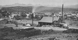
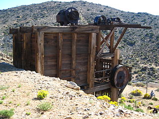
Ryan was a wealthy rancher who in 1895, bought out one of the main mining interests in the area from Johnny Lang. He located a steam-powered mill, large at the time, near the Colorado River, then had it disassembled to move it to the Lang mine site. In this desert area, he was able to provide the steam for the mill by building a 3.5 mile long, 2" pipeline from wells at his local ranch, now a historic site known as Ryan House and Lost Horse Well, [2] to a reservoir near the mill. Fuel to run the pumps piping the water up the needed 750 feet (230 m) elevation gain was provided from burning trees from nearby desert mountains. The deforestation that resulted is still visible in 2014, in the denuded hills. [1]

Johnny Lang was an American cattle driver who discovered Lost Horse Mine in Joshua Tree National Park. He claimed that he had moved to the area because his brother had been gunned down in New Mexico with six other cowboys. In 1890, in the process of herding their cattle, they lost their horses in what is now known as Lost Horse Valley. He tracked them to what is now known as Keys Desert Queen Ranch, which at that time was believed to be occupied by cattle rustlers from what known as the McHaney Gang, but did not find the horses. He then claimed he then met "Dutch" Frank, who claimed he discovered a rich gold claim but was afraid to develop it because he had been threatened by the purported rustlers. Lang and his father bought the rights to the mine, purportedly for $1,000.00, and named it "Lost Horse". He claimed to have taken on three partners as back-up, out of fear of the gang of purported rustlers or having his claim jumped. The four men filed their claim, set up a two-stamp mill and began to produce substantial amounts of gold. Lang's claim and mill were then sold to a Montana rancher named J.D. Ryan. Much of this history was provided by longtime Joshua Tree area resident long-time resident William F. Keys, a long-time resident, for whom Keys Ranch was named.

Colorado River major river in the western United States and Mexico

The Colorado River is one of the principal rivers in the Southwestern United States and northern Mexico. The 1,450-mile-long (2,330 km) river drains an expansive, arid watershed that encompasses parts of seven U.S. and two Mexican states. Starting in the central Rocky Mountains of Colorado, the river flows generally southwest across the Colorado Plateau and through the Grand Canyon before reaching Lake Mead on the Arizona–Nevada border, where it turns south toward the international border. After entering Mexico, the Colorado approaches the mostly dry Colorado River Delta at the tip of the Gulf of California between Baja California and Sonora.

Ryan House and Lost Horse Well

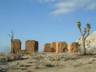
The Ryan House and Lost Horse Well are historic ruins in Joshua Tree National Park, California, United States. It was established by the family of J.D. Ryan, the later developers of the Lost Horse Mine, which became the most profitable mine in the area. The Lost Horse Well at the Ryan Ranch supplied water to the Lost Horse Mine, 3 miles (5 km) south and 750 feet (230 m), by pipeline.

Related Research Articles

Mojave National Preserve

Mojave National Preserve is a United States National Preserve located in the Mojave Desert of San Bernardino County, California, USA, between Interstate 15 and Interstate 40. The preserve was established October 31, 1994, with the passage of the California Desert Protection Act by the US Congress. Previously, it was the East Mojave National Scenic Area, under the jurisdiction of the Bureau of Land Management. Mojave National Preserve is vast. At 1,600,000 acres (650,000 ha), it is the third largest unit of the National Park System in the contiguous United States.

Eagle Mountain, California Ghost town in California, United States

Eagle Mountain, California, is a modern-day ghost town in the California desert in Riverside County founded in 1948 by noted industrialist Henry J. Kaiser. The town is located at the entrance of the now-defunct Eagle Mountain iron mine, once owned by the Southern Pacific Railroad, then Kaiser Steel, and located on the southeastern corner of Joshua Tree National Park. The town's fully integrated medical care system, similar to other Kaiser operations in California, was the genesis of the modern-day Kaiser Permanente health maintenance organization. Eagle Mountain is accessible by Riverside County Route R2, twelve miles (19 km) north of Desert Center, midway between Indio and the California/Arizona state line along Interstate 10. The town's relative youth and brief time of abandonment make Eagle Mountain among the country's best preserved ghost towns.

The Eagle Mountains are located in northeastern Riverside County, California, U.S.

Hexie Mountains

The Hexie Mountains are a desert mountain range located in Joshua Tree National Park, in southern California.

Ironwood Forest National Monument national monument in the Sonoran Desert of Arizona

Ironwood Forest National Monument is located in the Sonoran Desert of Arizona. Created by Bill Clinton by Presidential Proclamation 7320 on June 9, 2000, the monument is managed by the Bureau of Land Management, an agency within the United States Department of the Interior. The monument covers 188,619 acres (76,331 ha), of which 59,922 acres (24,250 ha) are non-federal and include private land holdings and Arizona State School Trust lands.

Darwin Falls Wilderness

The Darwin Falls Wilderness is the area adjacent to Darwin Falls, it has a unique location in the northern Mojave Desert, just west of Death Valley National Park. The Darwin falls Wilderness is a part of the National Wilderness Preservation System rooted by the California Desert Protection Act and guided by the Bureau of Land Management. The Darwin Falls Wilderness Area was founded on October 31, 1994 totaling up to 8,176 acres of land. The Darwin Wilderness is made up of several distinct landmarks, including The Darwin Plateau, an area between The Inyo Mountains to the north, and the Coso Range to the south. The wilderness area is also near the Darwin Hills, a mountain range in Inyo County and the Argus Range, west of the Panamint Range.

Silver mining in Arizona

Silver mining in Arizona was a powerful stimulus for exploration and prospecting in early Arizona. Cumulative silver production through 1981 totaled 490 million troy ounces. However, only about 10% of Arizona's silver production came from silver mining. More than 80% of the state's silver was a byproduct of copper mining; other silver came as a byproduct of lead, zinc, and gold mining.

Pinal City, Arizona Ghost town in Arizona, United States

Pinal or Pinal City is a ghost town in Pinal County in the U.S. state of Arizona. The town was populated from the 1870s into the 1890s, in what was then the Arizona Territory.

Sylvania Mountains Wilderness

The Sylvania Mountains Wilderness is a federally designated wilderness area located 30 miles (48 km) east of Bishop in the state of California. The wilderness is 18,677acres in size and is managed by the Bureau of Land Management (BLM). The California Desert Protection Act of 1994 created the Sylvania Mountains Wilderness and was added to the National Wilderness Preservation System. The wilderness is bordered by Nevada stateline on the east, Piper Mountain Wilderness on the west and Death Valley National Park to the south.

Desert Queen Mine

The Desert Queen Mine was one of the more successful and long-lived mines of the high desert in San Bernardino County, California. The abandoned mine is located in Joshua Tree National Park.

Keys Desert Queen Ranch human settlement in San Bernardino County, California, United States of America

The Keys Ranch is the prime example of early settlement in the Joshua Tree National Park area. Bill Keys was the area's leading character, and his ranch is a symbol of the resourcefulness of early settlers. The ranch is an extensive complex of small frame buildings built between 1910 and Keys' death in 1969. Keys pursued both ranching and mining to make a living in the desert.

Ruby Lee Mill Site

Ruby Lee Mill Site is located in the Hexie Mountains, in the Mojave Desert. The site is within Joshua Tree National Park, in Riverside County, California.

Lost Horse Mine

Lost Horse Mine is a historic gold and silver mine in the Lost Horse Valley of Joshua Tree National Park. Between 1894 and 1931, it produced 10,000 ounces of gold and 16,000 ounces of silver. It was first developed by Johnny Lang, then by J.D. Ryan. Scarce resources for steam powered pumps and mining equipment, led to denuding the local mountains of trees, which is still clearly visible in 2014.

Lost Palms Oasis Trail (Joshua Tree National Park)

Lost Palms Oasis Trail is a 7.2 mile day-hike trail located in the southernmost part of Joshua Tree National Park. The trail is generally completed in a loop. Known for the beautiful palm trees from which the trail gets its name, this hike is also known for its great bouldering, pools of water, and the ever-elusive "Victory Palms". Deemed by the National Park Service as a "Day-Use-Only" area, this trail is also home to bighorn sheep who use the pools as their main source of water.

Castle Mountains National Monument protected area in California

Castle Mountains National Monument is a U.S. National Monument located in the eastern Mojave Desert and northeastern San Bernardino County, in the state of California.

Gold Butte National Monument protected area in Nevada

Gold Butte National Monument is a United States national monument located in Clark County, Nevada, northeast of Las Vegas and south of Mesquite and Bunkerville. The monument protects nearly 300,000 acres of desert landscapes featuring a wide array of natural and cultural resources, including rock art, sandstone towers, and important wildlife habitat for species including the Mojave Desert tortoise, bighorn sheep, and mountain lion. The area also protects historic ranching and mining sites such as the ghost town of Gold Butte, although little but mine openings, cement foundations, and a few pieces of rusting equipment remains. The monument is managed by the Bureau of Land Management.

References

  1. 1 2 "Joshua Tree National Park, Lost Horse Mine". National Park Service .
  2. Zarki, Joseph W. (2015). Joshua Tree National Park. Charleston, SC: Arcadia (Images of America). p. 47. ISBN   978-1-4671-3281-7.