Blizne Ukrainian: Близне, Blyzne is a village in the administrative district of Gmina Jasienica Rosielna, within Brzozów County, Subcarpathian Voivodeship, in south-eastern Poland. It lies approximately 3 kilometres (2 mi) east of Jasienica Rosielna, 7 km (4 mi) north-west of Brzozów, and 32 km (20 mi) south of the regional capital Rzeszów. The village has a population of 2,800.

Haczów is a village in Brzozów County, Subcarpathian Voivodeship, in south-eastern Poland. It is the seat of the gmina called Gmina Haczów. It lies approximately 10 kilometres (6 mi) west of Brzozów and 42 km (26 mi) south of the regional capital Rzeszów. The village has a population of 3,370.
Gmina Brzozów is an urban-rural gmina in Brzozów County, Subcarpathian Voivodeship, in south-eastern Poland. Its seat is the town of Brzozów, which lies approximately 38 kilometres (24 mi) south of the regional capital Rzeszów.
Gmina Jasienica Rosielna is a rural gmina in Brzozów County, Subcarpathian Voivodeship, in south-eastern Poland. Its seat is the village of Jasienica Rosielna, which lies approximately 9 kilometres (6 mi) north-west of Brzozów and 32 km (20 mi) south of the regional capital Rzeszów.

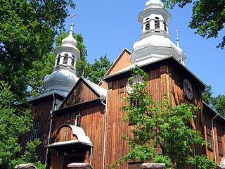
Domaradz is a village in Brzozów County, Subcarpathian Voivodeship, in south-eastern Poland. It is the seat of the gmina called Gmina Domaradz. It lies approximately 12 kilometres (7 mi) north-west of Brzozów and 28 km (17 mi) south of the regional capital Rzeszów. One of the old churches from Domaradz is entered into UNESCO World Heritage Site.
Jabłonica Ruska is a village in the administrative district of Gmina Dydnia, within Brzozów County, Subcarpathian Voivodeship, in south-eastern Poland. It lies approximately 4 kilometres (2 mi) east of Dydnia, 14 km (9 mi) east of Brzozów, and 40 km (25 mi) south of the regional capital Rzeszów.
Buków is a village in the administrative district of Gmina Haczów, within Brzozów County, Subcarpathian Voivodeship, in south-eastern Poland. It lies approximately 5 kilometres (3 mi) south-east of Haczów, 8 km (5 mi) south-west of Brzozów, and 44 km (27 mi) south of the regional capital Rzeszów. The village has a population of around 300 people.

Jasionów is a village in the administrative district of Gmina Haczów, within Brzozów County, Subcarpathian Voivodeship, in south-eastern Poland. It lies approximately 6 kilometres (4 mi) east of Haczów, 6 km (4 mi) south-west of Brzozów, and 43 km (27 mi) south of the regional capital Rzeszów.

Malinówka is a village in the administrative district of Gmina Haczów, within Brzozów County, Subcarpathian Voivodeship, in south-eastern Poland. It lies approximately 4 kilometres (2 mi) north-east of Haczów, 7 km (4 mi) west of Brzozów, and 38 km (24 mi) south of the regional capital Rzeszów.

Trześniów is a village in the administrative district of Gmina Haczów, within Brzozów County, Subcarpathian Voivodeship, in south-eastern Poland. It lies in the valley of the Wisłok river, approximately 4 kilometres (2 mi) south-east of Haczów, 8 km (5 mi) south-west of Brzozów, and 44 km (27 mi) south of the regional capital Rzeszów. The village has a population of 1,300.

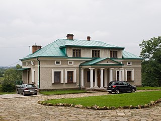
Wzdów is a village in the administrative district of Gmina Haczów, within Brzozów County, Subcarpathian Voivodeship, in south-eastern Poland. It lies approximately 10 kilometres (6 mi) south-east of Haczów, 9 km (6 mi) south of Brzozów, and 47 km (29 mi) south of the regional capital Rzeszów. The village has a population of 1,000. The palace at Wzdów was the seat the Polish noble family of Ostoja-Ostaszewski. After the expropriation of landlords in Poland by the communist regime in 1944/1945, the palace fell into ruin.
Jasienica Rosielna is a village in Brzozów County, Subcarpathian Voivodeship, in south-eastern Poland. It is the seat of the gmina called Gmina Jasienica Rosielna. It lies approximately 9 kilometres (6 mi) north-west of Brzozów and 32 km (20 mi) south of the regional capital Rzeszów.
Orzechówka is a village in the administrative district of Gmina Jasienica Rosielna, within Brzozów County, Subcarpathian Voivodeship, in south-eastern Poland. It lies approximately 3 kilometres (2 mi) south of Jasienica Rosielna, 7 km (4 mi) north-west of Brzozów, and 35 km (22 mi) south of the regional capital Rzeszów.
Wola Jasienicka is a village in the administrative district of Gmina Jasienica Rosielna, within Brzozów County, Subcarpathian Voivodeship, in south-eastern Poland. It lies approximately 5 kilometres (3 mi) west of Jasienica Rosielna, 12 km (7 mi) north-west of Brzozów, and 33 km (21 mi) south of the regional capital Rzeszów.
Hłudno is a village in the administrative district of Gmina Nozdrzec, within Brzozów County, Subcarpathian Voivodeship, in south-eastern Poland. It lies approximately 4 kilometres (2 mi) west of Nozdrzec, 14 km (9 mi) north-east of Brzozów, and 30 km (19 mi) south of the regional capital Rzeszów.
Rudawiec is a village in the administrative district of Gmina Nozdrzec, within Brzozów County, Subcarpathian Voivodeship, in south-eastern Poland. It lies approximately 10 kilometres (6 mi) south-west of Nozdrzec, 8 km (5 mi) north-east of Brzozów, and 34 km (21 mi) south of the regional capital Rzeszów.
Ryta Górka is a village in the administrative district of Gmina Nozdrzec, within Brzozów County, Subcarpathian Voivodeship, in south-eastern Poland. It lies approximately 11 kilometres (7 mi) north-west of Nozdrzec, 15 km (9 mi) north of Brzozów, and 24 km (15 mi) south of the regional capital Rzeszów.
Wesoła is a village in the administrative district of Gmina Nozdrzec, within Brzozów County, Subcarpathian Voivodeship, in south-eastern Poland. It lies approximately 9 kilometres (6 mi) west of Nozdrzec, 13 km (8 mi) north of Brzozów, and 27 km (17 mi) south of the regional capital Rzeszów.
Wara is a village in the administrative district of Gmina Nozdrzec, within Brzozów County, Subcarpathian Voivodeship, in south-eastern Poland. It lies approximately 3 kilometres (2 mi) south-east of Nozdrzec, 17 km (11 mi) north-east of Brzozów, and 34 km (21 mi) south-east of the regional capital Rzeszów.


