
Leszczawa Dolna is a village in the administrative district of Gmina Bircza, within Przemyśl County, Subcarpathian Voivodeship, in south-eastern Poland. It lies approximately 5 kilometres (3 mi) south-west of Bircza, 28 km (17 mi) south-west of Przemyśl, and 53 km (33 mi) south-east of the regional capital Rzeszów.
Blizne Ukrainian: Близне, Blyzne is a village in the administrative district of Gmina Jasienica Rosielna, within Brzozów County, Subcarpathian Voivodeship, in south-eastern Poland. It lies approximately 3 kilometres (2 mi) east of Jasienica Rosielna, 7 km (4 mi) north-west of Brzozów, and 32 km (20 mi) south of the regional capital Rzeszów. The village has a population of 2,800.
Gmina Brzozów is an urban-rural gmina in Brzozów County, Subcarpathian Voivodeship, in south-eastern Poland. Its seat is the town of Brzozów, which lies approximately 38 kilometres (24 mi) south of the regional capital Rzeszów.
Gmina Jasienica Rosielna is a rural gmina in Brzozów County, Subcarpathian Voivodeship, in south-eastern Poland. Its seat is the village of Jasienica Rosielna, which lies approximately 9 kilometres (6 mi) north-west of Brzozów and 32 km (20 mi) south of the regional capital Rzeszów.
Palędzie Dolne is a village in the administrative district of Gmina Mogilno, within Mogilno County, Kuyavian-Pomeranian Voivodeship, in north-central Poland. It lies approximately 9 kilometres (6 mi) west of Mogilno and 53 km (33 mi) south of Bydgoszcz.
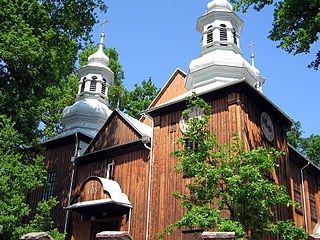
Domaradz is a village in Brzozów County, Subcarpathian Voivodeship, in south-eastern Poland. It is the seat of the gmina called Gmina Domaradz. It lies approximately 12 kilometres (7 mi) north-west of Brzozów and 28 km (17 mi) south of the regional capital Rzeszów. One of the old churches from Domaradz is entered into UNESCO World Heritage Site.
Buków is a village in the administrative district of Gmina Haczów, within Brzozów County, Subcarpathian Voivodeship, in south-eastern Poland. It lies approximately 5 kilometres (3 mi) south-east of Haczów, 8 km (5 mi) south-west of Brzozów, and 44 km (27 mi) south of the regional capital Rzeszów. The village has a population of around 300 people.

Jabłonica Polska is a village in the administrative district of Gmina Haczów, within Brzozów County, Subcarpathian Voivodeship, in south-eastern Poland. It lies approximately 4 kilometres (2 mi) north of Haczów, 9 km (6 mi) west of Brzozów, and 38 km (24 mi) south of the regional capital Rzeszów.

Malinówka is a village in the administrative district of Gmina Haczów, within Brzozów County, Subcarpathian Voivodeship, in south-eastern Poland. It lies approximately 4 kilometres (2 mi) north-east of Haczów, 7 km (4 mi) west of Brzozów, and 38 km (24 mi) south of the regional capital Rzeszów.

Trześniów is a village in the administrative district of Gmina Haczów, within Brzozów County, Subcarpathian Voivodeship, in south-eastern Poland. It lies in the valley of the Wisłok river, approximately 4 kilometres (2 mi) south-east of Haczów, 8 km (5 mi) south-west of Brzozów, and 44 km (27 mi) south of the regional capital Rzeszów. The village has a population of 1,300.

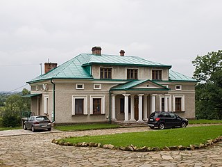
Wzdów is a village in the administrative district of Gmina Haczów, within Brzozów County, Subcarpathian Voivodeship, in south-eastern Poland. It lies approximately 10 kilometres (6 mi) south-east of Haczów, 9 km (6 mi) south of Brzozów, and 47 km (29 mi) south of the regional capital Rzeszów. The village has a population of 1,000. The palace at Wzdów was the seat the Polish noble family of Ostoja-Ostaszewski. After the expropriation of landlords in Poland by the communist regime in 1944/1945, the palace fell into ruin.
Jasienica Rosielna is a village in Brzozów County, Subcarpathian Voivodeship, in south-eastern Poland. It is the seat of the gmina called Gmina Jasienica Rosielna. It lies approximately 9 kilometres (6 mi) north-west of Brzozów and 32 km (20 mi) south of the regional capital Rzeszów.
Orzechówka is a village in the administrative district of Gmina Jasienica Rosielna, within Brzozów County, Subcarpathian Voivodeship, in south-eastern Poland. It lies approximately 3 kilometres (2 mi) south of Jasienica Rosielna, 7 km (4 mi) north-west of Brzozów, and 35 km (22 mi) south of the regional capital Rzeszów.
Wola Jasienicka is a village in the administrative district of Gmina Jasienica Rosielna, within Brzozów County, Subcarpathian Voivodeship, in south-eastern Poland. It lies approximately 5 kilometres (3 mi) west of Jasienica Rosielna, 12 km (7 mi) north-west of Brzozów, and 33 km (21 mi) south of the regional capital Rzeszów.
Izdebki is a village in the administrative district of Gmina Nozdrzec, within Brzozów County, Subcarpathian Voivodeship, in south-eastern Poland. It lies approximately 8 kilometres (5 mi) west of Nozdrzec, 10 km (6 mi) north-east of Brzozów, and 31 km (19 mi) south of the regional capital Rzeszów.
Rudawiec is a village in the administrative district of Gmina Nozdrzec, within Brzozów County, Subcarpathian Voivodeship, in south-eastern Poland. It lies approximately 10 kilometres (6 mi) south-west of Nozdrzec, 8 km (5 mi) north-east of Brzozów, and 34 km (21 mi) south of the regional capital Rzeszów.
Wesoła is a village in the administrative district of Gmina Nozdrzec, within Brzozów County, Subcarpathian Voivodeship, in south-eastern Poland. It lies approximately 9 kilometres (6 mi) west of Nozdrzec, 13 km (8 mi) north of Brzozów, and 27 km (17 mi) south of the regional capital Rzeszów.
Wołodź is a village in the administrative district of Gmina Nozdrzec, within Brzozów County, Subcarpathian Voivodeship, in south-eastern Poland. It lies approximately 6 kilometres (4 mi) south of Nozdrzec, 14 km (9 mi) east of Brzozów, and 37 km (23 mi) south-east of the regional capital Rzeszów.
Wara is a village in the administrative district of Gmina Nozdrzec, within Brzozów County, Subcarpathian Voivodeship, in south-eastern Poland. It lies approximately 3 kilometres (2 mi) south-east of Nozdrzec, 17 km (11 mi) north-east of Brzozów, and 34 km (21 mi) south-east of the regional capital Rzeszów.


