Related Research Articles
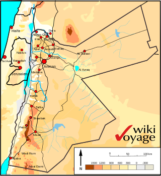
Jordan is situated geographically in West Asia, south of Syria, west of Iraq, northwest of Saudi Arabia, east of Israel and the Palestinian territory of the West Bank. The area is also referred to as the Middle or Near East. The territory of Jordan now covers about 91,880 square kilometres (35,480 sq mi).

The Kingdom of Saudi Arabia is a country situated in West Asia, the largest country on the Arabian Peninsula, bordering the Persian Gulf and the Red Sea. Its extensive coastlines provide great leverage on shipping through the Persian Gulf and the Suez Canal. The kingdom occupies 80% of the Arabian Peninsula. Most of the country's boundaries with the United Arab Emirates (UAE), Oman, and the Republic of Yemen are undefined, so the exact size of the country remains unknown. The Saudi government estimate is at 2,217,949 square kilometres, while other reputable estimates vary between 2,149,690 and 2,240,000 sq. kilometres. Less than 7% of the total area is suitable for cultivation, and in the early 1960s, population distribution varied greatly among the towns of the eastern and western coastal areas, the densely populated interior oases, and the vast, almost empty deserts.
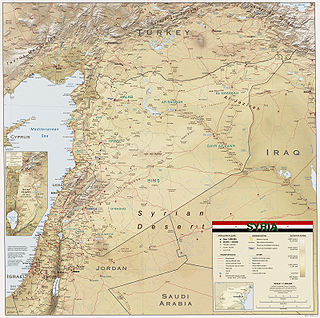
Syria is located in West Asia, north of the Arabian Peninsula, at the eastern end of the Mediterranean Sea. It is bordered by Turkey to the north, Lebanon and Israel to the west and southwest, Iraq to the east, and Jordan to the south. It consists of mountain ranges in the west and a steep area inland. In the east is the Syrian Desert and in the south is the Jabal al-Druze Range. The former is bisected by the Euphrates valley. A dam built in 1973 on the Euphrates created a reservoir named Lake Assad, the largest lake in Syria. The highest point in Syria is Mount Hermon on the Lebanese border at 2,814 metres or 9,232 feet. Between the humid Mediterranean coast and the arid desert regions lies a semiarid steep zone extending across three-quarters of the country, which receives hot, dry winds blowing across the desert. Syria is extensively depleted, with 28 percent of the land arable, 4 percent dedicated to permanent crops, 46 percent utilized as meadows and pastures, and only 3 percent forest and woodland.

The Kingdom of Bahrain consists of Bahrain Island and 33 of the 37 Bahrain Islands, lying in the Persian Gulf's Gulf of Bahrain off the north shore of West Asia's Arabian Peninsula. Bahrain's capital city is Manama. The islands are about 24 kilometers (15 mi) off the east coast of Saudi Arabia and 28 kilometers (17 mi) from Qatar. The total area of the country is about 694 square kilometers (268 sq mi), about four times the size of the District of Columbia.

The Sudd is a vast swamp in South Sudan, formed by the White Nile's Baḥr al-Jabal section. The Arabic word sudd is derived from sadd, meaning "barrier" or "obstruction". The term "the sudd" has come to refer to any large solid floating vegetation island or mat. The area which the swamp covers is one of the world's largest wetlands and the largest freshwater wetland in the Nile Basin.

The Jebel Akhdar or Al Jabal Al Akhdar is one of the Hajar Mountains in Ad Dakhiliyah Governorate of Oman. It rises to a height of 2,980 m (9,780 ft) and encompasses the Saiq Plateau at 2,000 m above sea level. Jebel Akhdar is famous for its labyrinth of wadis and terraced orchards, where pomegranates, apricots and roses grow in abundance due to its mild Mediterranean climate.

The Hauran is a region that spans parts of southern Syria and northern Jordan. It is bound in the north by the Ghouta oasis, eastwards by the al-Safa field, to the south by Jordan's desert steppe and to the west by the Golan Heights. Traditionally, the Hauran consists of three subregions: the Nuqrah and Jaydur plains, the Jabal al-Druze massif, and the Lajat volcanic field. The population of the Hauran is largely Arab, but religiously heterogeneous; most inhabitants of the plains are Sunni Muslims belonging to large agrarian clans, while Druze form the majority in the eponymous Jabal al-Druze and a significant Greek Orthodox and Greek Catholic minority inhabit the western foothills of Jabal al-Druze. The region's largest towns are Daraa, al-Ramtha and al-Suwayda.
Ibb is a governorate of Yemen. It is located in the inland south of the country with Ta'izz Governorate to the southwest, Ad Dali' Governorate to the southeast, Dhamar Governorate to the north, and short borders with Al Bayda' Governorate to the east and Al Hudaydah Governorate to the west. It has an area of 5,344 km² and a population estimated at around 1,665,000 in 2004, making it the most densely populated governorate in Yemen outside of San'a city.

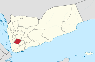
Taiz is a governorate of Yemen. The governorate's capital is Taiz, which is the third-largest city in Yemen. Today it is among the most important commercial centres in Yemen, owing to its proximity to rich farmland in the nation and to the important Red Sea port of Mocha. It also has an international airport, Taiz International Airport, with numerous services within Yemen and to neighbouring countries.

The Lajat, also spelled Lejat, Lajah, el-Leja or Laja, is the largest lava field in southern Syria, spanning some 900 square kilometers. Located about 50 kilometers (31 mi) southeast of Damascus, the Lajat borders the Hauran plain to the west and the foothills of Jabal al-Druze to the south. The average elevation is between 600 and 700 meters above sea level, with the highest volcanic cone being 1,159 meters above sea level. Receiving little annual rainfall, the Lajat is largely barren, though there are scattered patches of arable land in some of its depressions.
Al-Bireh, El Bire, Biré, El Bireh or Birra is a town in the Rashaya District, south-eastern portion of the Bekaa Governorate of the Republic of Lebanon. Al-Bireh is part of the Rashaya municipal district. It lies west of the road between Majdel Anjar and Rashaya. Its population is estimated to be 9000. It is a small Muslim town with two mosques and two schools.

Jaba' is a Palestinian village in the northern West Bank, in the Jenin Governorate of the State of Palestine, located 8 kilometres (5.0 mi) southwest of the city of Jenin. According to the Palestinian Central Bureau of Statistics, the village had a population of 8,942 in the 2007 census and 10,413 by 2017. The village is situated on the slopes of the Jabal Dabrun mountain. The village and its immediate vicinity contain a number of archaeological sites, including a tomb for a certain Neby Yarub. During the Ottoman era, Jaba' served as a throne village of the powerful Jarrar family. The village is administered by a municipal council, currently headed by Bassam Jarrar.
Jabal Bura is a granite mountain located in Bura east of Bajil, Yemen. The area is under consideration for inscription in UNESCO's list of sites that have "outstanding universal value."

Qurayyat is a small fishing town 83 km southeast of Muscat, Oman, adjacent to the towns of Sur, Diman Wa Tayeen and Aamerat.
Ain Halaqim is a village in northwestern Syria, administratively part of the Hama Governorate, located west of Hama. Nearby localities include al-Bayda and Masyaf to the north, al-Bayyadiyah to the northeast, Nisaf to the east, Kafr Kamrah to the southeast, Mashta al-Helu to the southwest, Ayn al-Shams to the west and Wadi al-Oyun to the northwest. According to the Syria Central Bureau of Statistics (CBS), Ain Halaqim had a population of 1,216 in the 2004 census. Its inhabitants are predominantly Christians.
Jabal es Saaïdé, Jabal es Saaide, Jabal as Sa`idah, Jabal as Sa`īdah, Jebal Saaidé, Jebel Saaidé or Jabal Saaidé is a Mountain in Lebanon near the inhabited village of Saaïdé, approximately 12 kilometres (7.5 mi) northeast of Baalbek, Lebanon.
The geology of the United Arab Emirates includes very thick Paleozoic, Mesozoic and Cenozoic marine and continental sedimentary rocks overlying deeply buried Precambrian. The region has extensive oil and gas resources and was deformed during the last several million years by more distant tectonic events.
Ayta al-Jabal or Aayta Ej Jabal, also Ayta ez-Zutt, is a village in Nabatiye Governorate, in the Bint Jbeil District of southern Lebanon, about 112 kilometres (70 mi) from Beirut. The village is situated in the southern outskirts of the town of Tebnine, in the heart of the Lebanese Shia Muslim community of Jabal Amel. The village sits on an elevation of 680 metres (2,230 ft) above sea level.
Maaroub, is a small town in the Tyre District of Southern Lebanon's South Governorate. It is characterized by a blend of old and new architecture. The town is divided into two parts: the old town, and the modern one that has recently arisen.
Barish is a local authority in Southern Lebanon, located in Tyre District, Governorate of South Lebanon.