Jacobs Ladder Bridge

Last updated

Jacobs Ladder Bridge
Jacobs Ladder Footbridge.jpg
Coordinates 36°50′38″S174°45′03″E / 36.843986°S 174.75079°E / -36.843986; 174.75079
Carries Pedestrians
Crosses Auckland Northern Motorway
Locale Saint Marys Bay, Auckland, New Zealand
Characteristics
Design Truss bridge
No. of spans2
History
Opened15 December 2012;11 years ago (2012-12-15)
Location
Jacobs Ladder Bridge

The Jacobs Ladder Bridge is a covered footbridge over State Highway 1 in Auckland, New Zealand. It was officially opened on 15 December 2012. [1]

The bridge connects Westhaven Marina, over the widened 10-lane motorway, to the Jacob's Ladder stairs leading up to the Saint Marys Bay suburb. The bridge is 102m long, 3.7m wide, and be 6m above the motorway with an internal height of 3m. The bridge was forecast to cost up to $5 million. [2] [3] [4] The final cost of the bridge was $7.9 million. [5]

The bridge provides a gateway statement to Auckland for travellers on the motorway, clad in a golden-coloured mesh network reminiscent of Maori fishing nets or fish traps, and it is lit up at night to provide a similar visual effect. [4]

Previously, the Jacob's Ladder stairs had come all the way down to the motorway level on the southern side, and then connected on the eastern side via a footpath. The stairs now only extend down as far as the bridge's crossing height, with ramped pedestrian paths running west and east along the motorway's southern side. On the northern side, stairs and an elevator provide access down to the marina car park. [4]

Construction was underway for abutments and column footings of the bridge as of early 2011. While Jacob's Ladder access was restored in time for the Rugby World Cup 2011, the new bridge was to be completed some time later. [6] In August 2011, the two trusses had been installed, and the floor slabs for the bridge were beginning to be installed, transport in place by a temporary "monorail" attached to the top of the truss. [7]

History of the name

The Bridge derives its name from the adjacent staircase, originally a wooden set of stairs dating from the late 19th or early 20th century and now replaced by a newer structure built at the same time as the bridge. The Auckland stairs derive their name, as do other similar stairs around the world, from a Biblical reference.

Jacob's Ladder is the colloquial name for a bridge between the Earth and heaven that the biblical Patriarch Jacob dreams about during his flight from his brother Esau, as described in the Book of Genesis. "And he dreamed, and behold, there was a ladder set up on the earth, and the top of it reached to heaven; and behold, the angels of God were ascending and descending on it!".

This name is applied to a number of steep public staircases throughout the world as well as being depicted on a large scale as sculptural elements on the facade of Bath Abbey. The name also has many other uses.

Related Research Articles

<span class="mw-page-title-main">M20 motorway</span> Motorway in Kent, England

The M20 is a motorway in Kent, England. It follows on from the A20 at Swanley, meeting the M25, and continuing on to Folkestone, providing a link to the Channel Tunnel and the ports at Dover. It is 50.6 miles (81.4 km) long. Although not signposted in England, this road is part of the European route E15. It is also used as a holding area for goods traffic when traffic across the English Channel is disrupted, such as Operation Stack and Operation Brock.

<span class="mw-page-title-main">Jacob's Ladder</span> Ladder in Genesis joining Earth to heaven

Jacob's Ladder is a ladder leading to heaven that was featured in a dream the biblical Patriarch Jacob had during his flight from his brother Esau in the Book of Genesis.

<span class="mw-page-title-main">Auckland Harbour Bridge</span> Road bridge in Auckland, New Zealand

The Auckland Harbour Bridge is an eight-lane motorway bridge over the Waitematā Harbour in Auckland, New Zealand. It joins St Marys Bay on the Auckland city side with Northcote on the North Shore side. It is part of State Highway 1 and the Auckland Northern Motorway. The bridge is operated by the NZ Transport Agency (NZTA). It is the second-longest road bridge in New Zealand, and the longest in the North Island.

<span class="mw-page-title-main">Māngere Bridge (bridges)</span> Bridge in New Zealand

Māngere Bridge, officially also called the Manukau Harbour Crossing, is a dual motorway bridge over the Manukau Harbour in south-western Auckland, New Zealand, crossing between the suburb also known as Māngere Bridge and the suburb of Onehunga.

<span class="mw-page-title-main">Saint Marys Bay, New Zealand</span> Suburb in Auckland, New Zealand

Saint Marys Bay is an inner suburb of Auckland, New Zealand.

<span class="mw-page-title-main">Panmure railway station, Auckland</span> Railway station in New Zealand

Panmure railway station is located on the North Island Main Trunk line in New Zealand. Eastern Line services of the Auckland railway network are the only regular services that stop at the station. The original Panmure Station opened on 16 November 1930, on a site to the south of the current station. The station was relocated to its current site in 2007. Panmure Station received a major upgrade and became a significant bus-rail interchange, as part of the AMETI project, during the 2012–2014 period.

<span class="mw-page-title-main">Northern Busway, Auckland</span> Busway in Auckland, New Zealand

The Northern Busway is a segregated busway that runs along the eastern side of the Northern Motorway, part of State Highway 1, in the north of Auckland, New Zealand, linking the North Shore with the northern end of the Auckland Harbour Bridge. As of May 2022, the busway consists of two-way lanes running between Albany Station and Akoranga Station, and from Akoranga Station a southbound-only lane that joins the harbour bridge approaches just south of the Onewa Road on-ramp system. The busway previously ended at Constellation before an extension to Albany was constructed in 2022.

Transport in Auckland, New Zealand's largest city, is defined by factors that include the shape of the Auckland isthmus, the suburban character of much of the urban area, a history of focusing investment on roading projects rather than public transport, and high car-ownership rates.

<span class="mw-page-title-main">Auckland Northern Motorway</span> Motorway located in Auckland, New Zealand

The Auckland Northern Motorway in the Auckland Region of New Zealand links Central Auckland and Warkworth in the former Rodney District via the Hibiscus Coast and North Shore. It is part of State Highway 1.

<span class="mw-page-title-main">State Highway 20 (New Zealand)</span> Road in New Zealand

State Highway 20 (SH 20), also known as the Southwestern Motorway, is a New Zealand state highway linking State Highway 1 at Manukau with State Highway 16 in Point Chevalier, via Māngere and Onehunga. Along with its spurs, State Highway 20A and 20B, the state highway serves Auckland Airport, the country's largest, therefore making SH 20 a key arterial route connecting the airport to the wider Auckland region and most of the upper North Island. The route also forms the southern part of the Western Ring Route, a 48 kilometres (30 mi) motorway route bypassing central Auckland.

<span class="mw-page-title-main">Newmarket Viaduct</span> Seven-lane state highway viaduct in Auckland

The Newmarket Viaduct is a seven-lane state highway viaduct in Auckland, New Zealand. The 700 m long viaduct, which is up to 20 m high, carries the Southern Motorway over the Newmarket suburb.

<span class="mw-page-title-main">Waterview Connection</span> Road in New Zealand

The Waterview Connection is a motorway section through west/central Auckland, New Zealand. It connects State Highway 20 in the south at Mt Roskill to State Highway 16 in the west at Point Chevalier, and is a part of the Western Ring Route.

<span class="mw-page-title-main">Victoria Park Tunnel</span> Vehicle tunnel in Auckland, New Zealand

The Victoria Park Tunnel is a motorway tunnel completed in 2012 on New Zealand State Highway 1 in Auckland, New Zealand, taking northbound traffic off the Victoria Park Viaduct, which was converted to all southbound traffic. It lies mostly under Victoria Park.

<span class="mw-page-title-main">Second Harbour Crossing, Auckland</span>

The Second Harbour Crossing is the name given to the proposed second transport link across the Waitematā Harbour in Auckland, New Zealand. Planners have also referred to new links across the harbour as the Additional Waitematā Harbour Crossing (AWHC) or the Waitematā Harbour Connections.

<span class="mw-page-title-main">Northwestern Cycleway</span> Cycle route in Auckland, New Zealand

The Northwestern Cycleway is a 12 km mostly off-road cycle route in New Zealand that connects the Auckland CBD with the suburb of Westgate. For most of its length, it runs alongside the Northwestern Motorway.

<span class="mw-page-title-main">Oakley Creek</span> Creek in New Zealand

Oakley Creek is a creek in Auckland, New Zealand. While heavily human-modified, it has a number of important ecological features, such as having the only natural waterfall on the Auckland isthmus.

<span class="mw-page-title-main">Jacob's Ladder (Saint Helena)</span> Stairway in Jamestown, Saint Helena

Jacob's Ladder is a Grade I listed staircase leading from Jamestown, Saint Helena, up the side of Ladder Hill to Ladder Hill Fort. The name is a reference to the biblical Jacob's Ladder, a ladder extending to heaven.

<span class="mw-page-title-main">Onehunga Harbour Road Bridge</span> Bridge in Onehunga, Auckland

The Onehunga Harbour Road Bridge is a walking and cycling bridge over Onehunga Harbour Road, a heavily trafficked road at the southwestern edge of Onehunga, New Zealand. The bridge provides easy and safe access from Onehunga to both the Waikaraka Cycleway running west–east, and Old Mangere Bridge to the south, which in turn links over the Mangere Inlet mouth of the Manukau Harbour. The bridge is 3.5m wide, and distinguished by its sweeping, curved structure.

<span class="mw-page-title-main">Westgate Pedestrian and Cycle Bridge</span> Bridge in Auckland, New Zealand

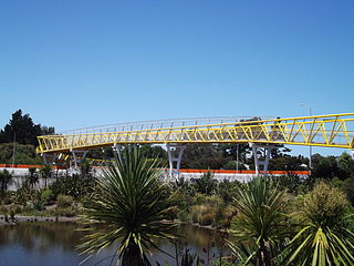
The Westgate Pedestrian and Cycle Bridge is a 209 metres (686 ft) long motorway overbridge crossing the Northwestern Motorway near Westgate in Auckland, New Zealand. Construction began in late 2012 and was completed in January 2013.

References

  1. "Footbridge opens safe new path for Auckland pedestrians", New Zealand Transport Agency. 15 December 2012. Retrieved 8 July 2013.
  2. Gateway to Auckland - The Aucklander , 12 November 2009, Page 5
  3. "Expensive sound barrier to reduce traffic noise for Auckland's wealthy". NZPA, via TVNZ . 19 February 2011. Retrieved 20 April 2011.
  4. 1 2 3 "The Jacobs Ladder footbridge" (PDF). Open day posters provided hy NZTA. April 2011. Retrieved 20 April 2011.
  5. "Bridge completes $340m project", Stuff.co.nz . 4 December 2012. Retrieved 8 July 2013.
  6. "Roads of national significance newsletter - Victoria Park Tunnel, Auckland: Push on to restore Jacobs Ladder stairs". New Zealand Transport Agency. 20 January 2011.
  7. "Roads of national significance newsletter - Victoria Park Tunnel, Auckland: Jacobs Ladder in place". New Zealand Transport Agency. 26 August 2011.